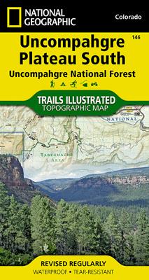
Wandelkaart - Topografische kaart 146 Uncompahgre Plateau South | National Geographic

0
Prachtige geplastificeerde kaart van het bekende nationaal park. Met alle recreatieve voorzieningen als campsites, maar ook met topografische details en wandelroutes ed. Door uitgekiend kleurgebruik zeer prettig in gebruik. Scheur en watervast!   National Geographic's Trails Illustrated map of Uncompahgre Plateau South is a two-sided, waterproof ...

Verkopers met dit product

Verkoper
Bezorging
Prijs
DeZwerver.nl logo
DeZwerver.nl
2,95
17,95

Anderen bekeken ook

Wandelkaart - Topografische kaart 146 Uncompahgre Plateau South | National Geographic
Prachtige geplastificeerde kaart van het bekende nationaal park. Met alle recreatieve voorzieningen als campsites, maar ook met topografische details en wandelroutes ed. Door uitgekiend kleurgebruik zeer prettig in gebruik. Scheur en watervast!   National Geographic's Trails Illustrated map of Uncompahgre Plateau South is a two-sided, waterproof map designed to meet the needs of outdoor enthusiasts with unmatched durability and detail. This map was created in conjunction with local land management agencies and is loaded with valuable recreation information.   The front side of the map details the southeastern portion of the Plateau and Uncompahgre National Forest, as well as Ridgway State Park. On the reverse side of the map, the southwestern portion of Uncompahgre National Forest, including the Naturita Division, is featured as well as the Tabeguache Area, Roubideau Special Management Area, Unaweep/Tabeguache Scenic and Historic Byway, and Dry Creek Basin and Dan Noble State Wildl…
17,95
Wandelkaart - Topografische kaart 147 Uncompahgre Plateau North | National Geographic
Prachtige geplastificeerde kaart van het bekende nationaal park. Met alle recreatieve voorzieningen als campsites, maar ook met topografische details en wandelroutes ed. Door uitgekiend kleurgebruik zeer prettig in gebruik. Scheur en watervast! National Geographic's Trails Illustrated map of Uncompahgre Plateau North is a two-sided, waterproof map designed to meet the needs of outdoor enthusiasts with unmatched durability and detail. This map was created in conjunction with local land management agencies and is loaded with valuable recreation information.   The front side of the map details the northeastern section of Uncompahgre National Forest and the Roubideau Area, the eastern portions of Dominguez Escalante National Conservation Area and Dominguez Canyons Wilderness, and the city of Delta. On the reverse side of the map, the northwestern section of Uncompahgre National Forest is featured as well as the Tabeguache Area, Grand Mesa National Forest, and the western portions of Domin…
17,95
Wandelkaart - Topografische kaart 141 Telluride, Silverton, Ouray, Lake City | National Geographic
Prachtige geplastificeerde kaart van het bekende nationaal park. Met alle recreatieve voorzieningen als campsites, maar ook met topografische details en wandelroutes ed. Door uitgekiend kleurgebruik zeer prettig in gebruik. Scheur en watervast!   Beautiful waterproof and tear-resistant topographical hiking map of a well-loved National Park, with campsites and walking routes clearly marked. Coverage area includes parts of San Juan and Uncompahgre national forests; south San Juan Mountains; Lizard Head, Mt Sneffels and Uncompahgre wilderness areas; Calico National Recreation Trail; portions of the Colorado Trail; the trail networks at Coal Bank Pass and Silver Jack Reservoir; and the cities and surrounds of Telluride and Ouray. 14ers: Mt Wilson, El Diente Peak, Wilson Peak, Mt Sneffels, Uncompahgre Peak, Wetterhorn Peak, Redcloud Peak, Sunshine Peak. Includes UTM grids for use with your GPS unit.
17,95
Wandelkaart - Wegenkaart - landkaart 902 Jasper South National Park | National Geographic
Goede kaart van een deel van Jasper National Park. Geschikt voor overzicht maar ook voor de langere trails: campsites, rivieren, paden, alles kun je er op terug vinden.   National Geographic's Trails Illustrated map of Jasper South is a two-sided, waterproof map designed to meet the needs of outdoor enthusiasts with unmatched durability and detail. This map was created in conjunction with local land management agencies and is loaded with valuable recreation information.   The front side of the Jasper South map details the east side of the national park, from Whitehorse Wildland Provincial Park to the north, to White Goat Wilderness Area to the south. The reverse side of the map details the west side of the park, extending from Cummins Lakes Provincial Park to the south, to Victoria Cross Ranges to the North. Insets show survival tips, safe travel in Bear Country, and all the recreation the park has to offer with backpacking, camping, biking, hiking and horseback riding.   Trails …
17,50
Wandelkaart - Topografische kaart 748 Green Mountain National Forest South - Robert T. Stafford White Rocks NRA - Manchester | National Geographic
Prachtige geplastificeerde kaart van het bekende nationaal park. Met alle recreatieve voorzieningen als campsites, maar ook met topografische details en wandelroutes ed. Door uitgekiend kleurgebruik zeer prettig in gebruik. Scheur en watervast! National Geographic's Green Mountain National Forest South Trails Illustrated topographic map is the most comprehensive available for outdoor enthusiasts of all types. Designed to be easy-to-read, yet highly detailed – this map includes a comprehensive road and trail network distinguishing between major, secondary and 4x4 roads, hiking, horse, biking, multi-use and non-motorized winter trails. All forest roads are labeled with their official road number and trails are clearly identified with their given name. Land management boundaries are color-coded showing National Forest, Ranger District, Wilderness Areas, Conservation Areas and more, plus the locations of private land within the Green Mountain National Forest. The renowned Appalachian Trai…
17,95
Wandelkaart - Topografische kaart 263 Grand Canyon West | National Geographic
Prachtige geplastificeerde kaart van het nationaal park. Met alle recreatieve voorzieningen als campsites, maar ook met topografische details en wandelroutes ed. Door uitgekiend kleurgebruik zeer prettig in gebruik. Scheur en watervast! National Geographic's Trails Illustrated map of Grand Canyon West covers some of the less frequented but just as wondrous landscape of Grand Canyon National Park, from Powell Plateau to the park's western boundary. Expertly researched and created in partnership with the National Park Service, U.S. Forest Service, Bureau of Land Management and others, the map also covers the surrounding areas of Kaibab National Forest, Hualapai Havasupai Indian Reservations and Parashant National Monument. With so much of the area being backcountry, the map also includes useful backcountry information, regulations and safety tips, in addition to a backcountry use area guide, color-coded by degree of experience required.   Clearly marked trails, including unmaintained pr…
16,95
Wandelkaart - Topografische kaart 254 Chilkoot Trail | National Geographic
Prachtige geplastificeerde kaart van het nationaal park. Met alle recreatieve voorzieningen als campsites, maar ook met topografische details en wandelroutes ed. Door uitgekiend kleurgebruik zeer prettig in gebruik. Scheur en watervast!   National Geographic's Trails Illustrated map for Chilkoot Trail in Klondike Gold Rush National Historic Park in the Alaskan panhandle is perfect for hiking, camping, and wildlife viewing in this scenic, rugged frontier. Created in partnership with local land management agencies, this expertly researched map features key areas of interest including Chilkoot Trail National Historic Site; portions of the Klondike Highway; Happy Camp; Taiya Inlet; the town of Skagway; Klondike Gold Rush National Historical Park; Skagway River; Dyea; and Deep, Bennett, Crater, Long, and Lindeman lakes.   The print map includes insets of historic routes to the Klondike gold fields, Historic Dyea, and Skagway Historic District with some of the prominent gold rush-era bui…
16,95
Wandelkaart - Topografische kaart 220 Dinosaur National Monument | National Geographic
Prachtige geplastificeerde kaart van het bekende nationaal park. Met alle recreatieve voorzieningen als campsites, maar ook met topografische details en wandelroutes ed. Door uitgekiend kleurgebruik zeer prettig in gebruik. Scheur en watervast! This Trails Illustrated topographic map for Dinosaur National Monument, which straddles the state lines of northwest Colorado and northeast Utah, is the perfect recreational map for this stunning monument. Within its craggy hills, you can discover pieces of a long ago world where the largest land creatures of all time once roamed and died.   The map includes the entire national monument area, with detailed trails and topographic information. Included are the Lodore Nature Trail, The Green River, Yampa River, Jenny Lind Rock, Harpers Corner Nature Trail, Rainbow Park, Dinosaur Quarry, the Green Riuver Campground, and much more. The map is full of detailed trail information, park information, history and culture, geology, and natural history.
16,95
Wandelkaart - Topografische kaart 211 Arches National Park | National Geographic
Prachtige geplastificeerde kaart van het nationaal park. Met alle recreatieve voorzieningen als campsites, maar ook met topografische details en wandelroutes ed. Door uitgekiend kleurgebruik zeer prettig in gebruik. Scheur en watervast! Trails Illustrated maps are the most trusted and popular recreation maps available. Continually setting the standard for accuracy, each map is crafted in conjunction with local land managers, and undergoes rigorous review and enhancement before being printed on waterproof, tear-resistant material. Each Trails Illustrated map contains detailed topographic information, clearly marked and named trails, recreational points of interest, and navigational aids. National Park series maps contain useful details for planning your visit. State series titles cover popular recreation areas, ideal for done-in-a-day activities. Included on the map are Arches National Park, The Highlands, Little Valley, Devils Garden, Lost Spring Canyon Wilderness area, Negro Bill Wil…
16,95
Wandelkaart - Topografische kaart 210 Canyonlands National Park | National Geographic
Prachtige geplastificeerde kaart van het nationaal park. Met alle recreatieve voorzieningen als campsites, maar ook met topografische details en wandelroutes ed. Door uitgekiend kleurgebruik zeer prettig in gebruik. Scheur en watervast! Trails Illustrated maps are the most trusted and popular recreation maps available. Continually setting the standard for accuracy, each map is crafted in conjunction with local land managers, and undergoes rigorous review and enhancement before being printed on waterproof, tear-resistant material. Each Trails Illustrated map contains detailed topographic information, clearly marked and named trails, recreational points of interest, and navigational aids. National Park series maps contain useful details for planning your visit. State series titles cover popular recreation areas, ideal for done-in-a-day activities. Included on the map are Canyonlands National Park, the Island in the Sky district, the Needles district, and the Maze district. The map also …
16,95

Klanten-reviews van Wandelkaart - Topografische kaart 146 Uncompahgre Plateau South | National Geographic

Er zijn nog geen beoordelingen voor dit productBen jij de eerste die een review plaatst?

Meer over Wandelkaart - Topografische kaart 146 Uncompahgre Plateau South | National Geographic

Productomschrijving

Prachtige geplastificeerde kaart van het bekende nationaal park. Met alle recreatieve voorzieningen als campsites, maar ook met topografische details en wandelroutes ed. Door uitgekiend kleurgebruik zeer prettig in gebruik. Scheur en watervast!   National Geographic's Trails Illustrated map of Uncompahgre Plateau South is a two-sided, waterproof map designed to meet the needs of outdoor enthusiasts with unmatched durability and detail. This map was created in conjunction with local land management agencies and is loaded with valuable recreation information.   The front side of the map details the southeastern portion of the Plateau and Uncompahgre National Forest, as well as Ridgway State Park. On the reverse side of the map, the southwestern portion of Uncompahgre National Forest, including the Naturita Division, is featured as well as the Tabeguache Area, Roubideau Special Management Area, Unaweep/Tabeguache Scenic and Historic Byway, and Dry Creek Basin and Dan Noble State Wildlife Areas.   The Uncompahgre Plateau South map is printed in the United States on durable synthetic paper, making it waterproof, tear-resistant, and trail tough — capable of going anywhere you do. The map is two-sided, and can be folded to a packable size of 4.25" x 9.25"; unfolded size is 26" x 38".   Net proceeds from the sale of this map go to support the nonprofit mission of the National Geographic Society.   Key Features:
  • Waterproof and tear-resistant
  • Detailed road network and clearly marked trails for hiking, biking, horseback riding, skiing, ATV and more
  • Detailed topography and clearly defined, color-coded boundaries of national forests, state parks, wilderness areas, and wildlife refuges
  • Hundreds of points-of-interest, including trailheads, campgrounds, boat launches, fishing, ranger stations and more
  • UTM and Latitude/Longitude grid, as well as selected waypoints and a scale bar for easy and accurate navigation.
  • Useful information on United States Forest Service trail travel management and vehicle use
  • Important contact information for local land management agencies
  • Information on special areas including Roubideau Special Management Area and Tabeguache Area
 

Productinformatie

    Verken gerelateerde categorieën

    Webshop.nl maakt gebruik van cookies. Ga je verder op onze website, ga dan akkoord met het plaatsen van cookies en de verwerking van deze data door ons en vermelde partners.