webshop.nl
Categorieën
  Sluiten

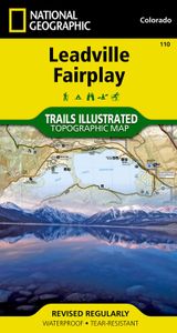
Wandelkaart - Topografische kaart 110 Trails Illustrated Leadville Fairplay | National Geographic

Prachtige geplastificeerde kaart van het bekende nationaal park. Met alle recreatieve voorzieningen als campsites, maar ook met topografische details en wandelroutes ed. Door uitgekiend kleurgebruik zeer prettig in gebruik. Scheur en watervast!   Beautiful waterproof and tear-resistant topographical hiking map of a well-loved National Park, with ca...
16,95

Webshops met dit product

Webshop
Bezorging
Prijs

Klanten-reviews van Wandelkaart - Topografische kaart 110 Trails Illustrated Leadville Fairplay | National Geographic

Er zijn nog geen beoordelingen voor dit productBen jij de eerste die een review plaatst?

Meer over Wandelkaart - Topografische kaart 110 Trails Illustrated Leadville Fairplay | National Geographic

Productomschrijving

Prachtige geplastificeerde kaart van het bekende nationaal park. Met alle recreatieve voorzieningen als campsites, maar ook met topografische details en wandelroutes ed. Door uitgekiend kleurgebruik zeer prettig in gebruik. Scheur en watervast!   Beautiful waterproof and tear-resistant topographical hiking map of a well-loved National Park, with campsites and walking routes clearly marked. Coverage includes the Pike and San Isabel national forests, Buffalo Peaks Wilderness Area, and the cities of Fairplay, Leadville, Malta, and Granite. Also included are the Twin Lakes and Clear Creek reservoirs, Mt Massive Lakes, a segment of the Arkansas River, and Breakneck, Weston and Browns passes. 14ers: Mt Sherman. Portions of the Continental Divide Trail and Colorado Trail are covered on this map. Includes UTM grids for use with your GPS unit, and CO Game Management Unit (GMU) boundaries.  

Verken gerelateerde categorieën

Webshop.nl maakt gebruik van cookies. Ga je verder op onze website, ga dan akkoord met het plaatsen van cookies en de verwerking van deze data door ons en vermelde partners.