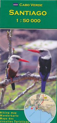
Wandelkaart Santiago - Kaapverdische Eilanden | AB Kartenverlag

0
Santiago Island in the Cape Verde archipelago on a detailed, GPS compatible map at 1:50,000 from AB Kartenverlag, highlighting 33 hiking and mountain bike routes and including small plans of Praia, Tarrafal and Cidade Velha.    The map is double-sided with a very generous overlap between the sides. Contours with relief shading and spot heights pre...

Verkopers met dit product

Verkoper
Bezorging
Prijs
DeZwerver.nl logo
DeZwerver.nl
niet bekend
17,95

Anderen bekeken ook

Wandelkaart Tatry Zachodnie | Sygnatura
Goede wandelkaart van het grote westelijke deel van het Tatra gebergte, zowel aan de Poolse als aan de SLowaakse kant. Wandelpaden, campings, hutten, alles staat er op.  Western Tatra Mountains in Poland and Slovakia at 1:25,000 on a contoured and GPS compatible map from CartoMedia highlighting waymarked hiking trails, mountain huts and campsites, places of interest, etc, Coverage extends from Zakopane westwards to Habovka. On the reverse are panels with an overview of the waymarked hiking trails for planning longer routes, a road map showing access to this part of the Tatra Mountains from both sides of the border, a directory of local mountain huts and other useful tourist information, etc.   Maps in the Cartomedia hiking series present topography is by contours at 20m intervals, enhanced by relief shading and, where appropriate, graphic relief for exposed rocky areas. Waymarked hiking trails indicate approximate walking times in both directions and possible danger points. Most title…
9,95
Wandelkaart Beskid Slaski - Wista en Szczyrk - Beskiden | Sygnatura
De kaart beslaat de hele Silezische Beskiden, van Bielsko-Biała tot Zwardoń en van de Shelter bij Tułem tot Kotlina Żywiecka.   Vertaling van Google Translate:    De legende bevat ongeveer 90 karakters, beschreven in 5 talen (PL, GB, D, SK, F). Zeer levendige, kleurrijke schaduwen en contourlijnen om de 20 m geven het terrein duidelijk weer. De karakteristieke kenmerken van de kaart zijn: een dicht netwerk van paden en wegen, overzichtelijke accommodaties en toeristische, paard- en skiroutes, maar ook fiets- en skiroutes, overzichtelijke skiliften en kabelbanen, zorgvuldig berekende passeertijden, GPS-raster, gedetailleerde gebouwen duidelijk zichtbaar, zelfs in bossen.   De gids op de achterkant van de kaart is zeer gevarieerd en kleurrijk. Naast geografische informatie over het gebergte is er gedetailleerde informatie over alle PTTK-schuilplaatsen met hun foto's. Ook andere accommodaties in de bergen werden niet vergeten. Er is: een schema van paden met plastic schaduw, dekking voor…
9,95
Wegenkaart - landkaart South Africa: Swartberg & Klein-Karoo | Slingsby Maps
All roads from National Highways to minor gravel roads are shown; the many classifications that indi- cate the quality of each road help you plan your route No less than 28 mountain passes are shown — all are public roads! Distances are clearly shown; comprehensive 4 x 4 information GPS coordinates in DD MM SS format are provided for every road-junction All tourism facilities and accommodation establishments are shown in the out-of-town areas; there are insets of the major towns The map links to our maps of the Baviaanskloof, the Garden Route, Overberg and the Tankwa-Karoo Additional info:   Swartberg and Klein-Karoo region on a contoured and GPS compatible, double-sided, waterproof and   tear-resistant map at 1:160,000 from Slingsby Maps, with excellent topographic detail and plenty of tourist information, including street plans of ten main towns.   The map provides a very detailed picture of this mountainous terrain, with altitude colouring, shading, con- tours at 20m intervals and …
29,95
Wegenkaart - landkaart SC3-SC4 Swellendam to Mossel Bay | Tracks4Africa
The Cape to Addo map series covers the southern parts of the Western Cape of South Africa in a series of eight highly detailed maps, printed on four sheets of A1 durable paper.   We start in Cape Town in the west and move along the southern coast through the Overberg, Winelands, Garden Route, Klein Karoo R62, Baviaanskloof to eventually arrive in the Addo National Park up to Gqeberha (Port Elizabeth) in the east.   The maps are highly detailed and well researched. Our map scale is 1:200 000 which allows us to show a lot of detail including minor gravel roads, hiking trails, farm boundaries and points of interest which are relevant to self-drive tourists.   The size of the paper is kept small enough to allow this to be the perfect road tripping map. We use Duraflex paper and print two maps per sheet of A1 paper, making this a four-sheet series. Each map sheet is individually packed in a plastic protective sleeve.   The maps are perfect for day drives, overlanding or just doing road tri…
29,95
Wegenatlas IJsland met stadsplattegronden | Ferdakort
Super handige kleine wegenatlas van IJsland (schaal 1:500.000) met vooral een enorme hoeveelheid plattegronden van steden en dorpen, enkele themakaarten en een groot register. De kaarten zijn uitstekend leesbaar en de atlas in in een mooie ringband uitgevoerd.  Road Atlas of Iceland at 1:500,000 from Ferðakort, published in a handy 15x25cm spiral-bound format, with an index of over 3,000 entries, a comprehensive distance table, 46 street plans including Reykjavik and several thematic map sincluding cultural heritage and geology.   The whole of Iceland is covered at 1:500,000 with the road network distinguishing between paved and gravel roads, and showing which small local roads are maintained by the country’s government. Fords, locations of petrol stations, driving distances and car ferry routes are marked. National parks and other protected areas are highlighted and symbols mark locations of various places of interest: different types of tourist accommodations including campsites, re…
30,95
Wandelkaart Outdoorkarte Madeira - Funchal - Porto Santo | Kümmerly & Frey
Hele goede wandelkaart met alle noodzakelijke topografische details van Madeira met ingetekende routes. De kaart is geplastificeerd, met kleine plattegrond van Funchal. Madeira at 1:40.000 on a contoured, GPS compatible outdoor map from Kümmerly + Frey printed on sturdy waterproof and tear-resistant synthetic paper. The map is double-sided on a more convenient size sheet and includes a street plan of central Funchal, plus coverage of the nearby Islas Desertas and Porto Santo at 1;70,000.   The map divides Madeira east/west with a very generous overlap between the sides. Topography is shown by contours at 20m intervals, enhanced by relief shading and spot heights, plus colouring and/or graphics to indicate different types of terrain and vegetation.. Waymarked hiking trails and footpaths are highlighted by overprint which indicates narrow steep sections. The map also shows cycle routes plus a selection of mountain bike and horse riding trails.   A wide range of symbols indicate various …
13,50
Wandelkaart Cabo de Gata / Nijar | Editorial Alpina
Zeer gedetailleerde wandelkaart van een klein gebied. Met ingetekende wandelroutes en andere informatie. Spaanstalig, maar uitstekende kaart. Coordinaten zijn weergegeven, dus GPS compatible met UTM grid.    Op de topografische wandelkaart worden o.a. berghutten, campings aangeduid en hoogtelijnen, ingetekende wandelroutes en de GR paden (doorgaande langeafstandswandelpaden).  Cabo da Gata-Níjar Natural Park in an extensive and very popular series of walking maps from Editorial Alpina covering the Pyrenees, Catalonia and other selected hiking areas in Spain, including Picos de Europa, Sierra Nevada and parts of Andalucía, Majorca, etc. Scales vary from 1:50,000 to 1:10,000, with the majority of the titles at 1:25,000. The maps have contours, usually at 20m or 10m intervals, with additional hill shading and spot heights. An overprint highlights hiking trails, long-distance footpaths, campsites, mountain huts, refuges, etc. Many maps also show climbing sites, potholing caves, mountain b…
17,95
Wegenkaart - landkaart Explorer Map North Queensland | Hema Maps
Detailkaart van een deel van Australië. Zeer goed leesbaar, met naast de topografische details veel symbolen waarmee allerhande toeristische zaken worden aangeduid als campsites, nationale parken, attracties, wandelmogelijkheden etc. Covering Australia's beautiful North Queensland. There is alot of town map insets, tourist information, and photographs on the reverse side Touring map of the northern half of Queensland, with enlargements of popular areas, street plans, lists of facilities, etc. The main map extends south to well beyond the Flinders Highway between Townsville and Mount Isa, including Mackay on the coast. The map shows the road network, including minor roads and unsurfaced tracks, plus railways and local airfields/aerodromes. Designated Tourist Routes are highlighted and symbols mark places of interest (many annotated with brief description), historical sites, tourist resorts, youth hostels, etc. Topography is indicated by names of mountain ranges and peaks, as well as by…
17,50
Wandelkaart 08 Bragg Creek and Sheep Valley | Gem Trek Maps
Gem Trek’s BRAGG CREEK & SHEEP VALLEY MAP is for hikers and outdoor enthusiasts looking to explore Kananaskis Country west and south of Bragg Creek. Whether you are touring along the roads or heading into the backcountry, you’ll find the waterproof and tear-resistant Bragg Creek & Sheep Valley Map to be an invaluable tool.   This map features detailed cartography, accurate hiking trails with distances, and details such as logging roads, campgrounds, equestrian routes, picnic areas, and fire lookouts.   On the back of the Bragg Creek & Sheep Valley Map are detailed descriptions of 20 hiking trails colour-coded by region, eight mountain bike trails, as well details of services such as campgrounds and visitor centres.   Bragg Creek & Sheep Valley Map Coverage The Bragg Creek & Sheep Valley Map covers a large chunk of the eastern portion of Alberta’s Kananaskis Country. The map centres on the Elbow Valley, which is accessed from the village of Bragg Creek, a short drive southwest of Calga…
18,95
Wegenkaart - landkaart Dalmatische Kust | Freytag & Berndt
Uitstekende tweezijdige wegenkaart van een  groot deel van de Dalmatische kust van Kroatie. Zeer gedetailleerde kaart met topografische details, maar ook campings. Ideaal om deze eilanden per boot of auto / fiets te ontdekken. Alle bezienswaardigheden staan zeer goed aangegeven. Met register en enkele stadsplattegronden. Dalmatian Coast "Top 10 Tips" Map at 1:150,000 from Freytag & Berndt with a booklet containing an index, brief descriptions of region’s 10 most popular destinations, plus street plans of Dubrovnik’s Old Town and central Pula, Rijeka, Split, Sibenik and Zadar.   The map is double-sided and presents the region in three sections, as indicated on our area coverage image (NB. Istrian Peninsula is included). Topography is shown by relief shading with spot heights, with plenty of names of mountain and hill chains, etc. National parks and other protected areas are clearly marked.    Road network includes small local roads and selected cart tracks, and indicates motorway servi…
14,95

Klanten-reviews van Wandelkaart Santiago - Kaapverdische Eilanden | AB Kartenverlag

Er zijn nog geen beoordelingen voor dit productBen jij de eerste die een review plaatst?

Meer over Wandelkaart Santiago - Kaapverdische Eilanden | AB Kartenverlag

Productomschrijving

Santiago Island in the Cape Verde archipelago on a detailed, GPS compatible map at 1:50,000 from AB Kartenverlag, highlighting 33 hiking and mountain bike routes and including small plans of Praia, Tarrafal and Cidade Velha.    The map is double-sided with a very generous overlap between the sides. Contours with relief shading and spot heights present the topography. The map shows the network of local roads, tracks and footpaths. Symbols indicate locations of viewpoints, diving sites and medical facilities.   33 selected walks, from one to five hours long, are highlighted on the map and listed in a table with details of the terrain, altitude, degree of difficulty and suitability as mountain bike routes. Map legend and all the accompanying text include English.   Also included are small plans of Praia, Tarrafal and Cidade Velha, indicating main facilities.

Verken gerelateerde categorieën

Webshop.nl maakt gebruik van cookies. Ga je verder op onze website, ga dan akkoord met het plaatsen van cookies en de verwerking van deze data door ons en vermelde partners.