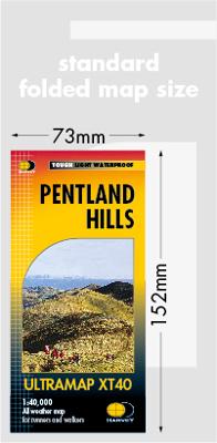
Wandelkaart Pentland Hills | Harvey Maps

0
Covers a large area yet is handily compact. Pocket perfect!Detailed map for runners and walkers of the whole of the Pentlands at the magic scale of 1:40,000 on one side of one sheet.Caerketton and Allermuir Hills provide panoramic views over Edinburgh and the Forth.Includes Scald Law and Carnethy Hill....

Verkopers met dit product

Verkoper
Bezorging
Prijs
DeZwerver.nl logo
DeZwerver.nl
2,95
19,50

Anderen bekeken ook

Nieuw
Wandelkaart Arran | Harvey Maps
Covers a large area yet is handily compact. Pocket perfect!   Features the renowned Goat Fell, A'Chir ridge, Beinn Bharrain, Glen Sannox & Glen Rosa.   Detailed map for runners and walkers of the whole island at the magic 1:40,000 scale.   The 100km (62 miles) Arran Coastal Way is also shown. The route links the coastline of the island with the villages and the stunning scenery Arran has to offer.   Includes Gaelic-English glossary and information on local archaeological and historical sites.   Includes 4 Corbetts and 1 Graham.
19,50
Nieuw
Wandelkaart Dartmoor Noord | Harvey Maps
Covers a large area yet is handily compact. Pocket perfect!   Detailed map for runners and walkers of the north section of Dartmoor National Park at the magic scale of 1:40,000.   Features Dartmoor's famous Tors including Haytor Rocks, Yes Tor and High Willhays.   Archaeological sites include standing stones, stone circles and ancient travel routes are also shown.   Fully detailed genuine HARVEY mapping Includes Rights of Way Use without a map case: tough and 100% waterproof Opens directly to either side of the sheet
19,50
Nieuw
Wandelkaart Dartmoor Zuid | Harvey Maps
Covers a large area yet is handily compact. Pocket perfect!   Detailed map for runners and walkers of the south section of Dartmoor National Park at the magic scale of 1:40,000.   Features Dartmoor's famous Tors and archaeological sites include standing stones, stone circles and ancient travel routes are also shown.   Click here to view map coverage   Fully detailed genuine HARVEY mapping Includes Rights of Way Use without a map case: tough and 100% waterproof Opens directly to either side of the sheet
19,50
Nieuw
Wandelkaart Suilven / Stac Pollaidh / Lochinver | Harvey Maps
Detailed map for runners and walkers of Suilven and the surrounding area at the magic scale of 1:40,000. Covers a large area yet is handily compact. Pocket perfect! This is a fantastic and beautiful area, with Suilven at its centre. The map includes the two Munros of Ben More Assynt and Conival, as well as other famous mountains such as Cul Mor, Cul Beag, Canisp and Stac Pollaidh. Coverage is extended to the north with an inset of Quinag. The map shows 2 Munros, 8 Corbetts and 3 Grahams. Fully detailed genuine HARVEY mapping Use without a map case: tough and 100% waterproof Opens directly to either side of the sheet
19,50

Klanten-reviews van Wandelkaart Pentland Hills | Harvey Maps

Er zijn nog geen beoordelingen voor dit productBen jij de eerste die een review plaatst?

Meer over Wandelkaart Pentland Hills | Harvey Maps

Productomschrijving

Covers a large area yet is handily compact. Pocket perfect!Detailed map for runners and walkers of the whole of the Pentlands at the magic scale of 1:40,000 on one side of one sheet.Caerketton and Allermuir Hills provide panoramic views over Edinburgh and the Forth.Includes Scald Law and Carnethy Hill.

Verken gerelateerde categorieën

Webshop.nl maakt gebruik van cookies. Ga je verder op onze website, ga dan akkoord met het plaatsen van cookies en de verwerking van deze data door ons en vermelde partners.