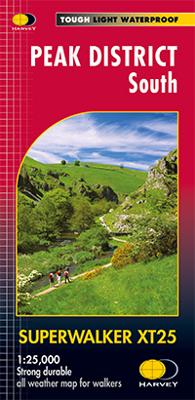
Wandelkaart Peak District South | Harvey Maps

0
Een bijzonder handige kaart van dit gebied. Op waterafstotend papier met veel details.  Covers the area from Buxton to Matlock. Includes Leek, the Roaches and Dovedale.   Detailed map for hillwalkers of the White Peak at the popular 1:25,000 scale.    Tough, light, durable and 100% waterproof Genuine, original, HARVEY mapping Includes Rights of...

Verkopers met dit product

Verkoper
Bezorging
Prijs
DeZwerver.nl logo
DeZwerver.nl
2,95
24,95

Anderen bekeken ook

Nieuw
Wandelkaart Peak District Central | Harvey Maps
New Superwalker XT25 of the Peak District Revised and re-designed. It's got everything! Genuine original HARVEY mapping at 1:25,000. Ideal for walking. Clear, easy to read. Easy to re-fold. Opens directly to either side of the sheet. Slim and flexible. Light to carry. Tearproof and durable. AND 100% waterproof as standard The Peak District National Park on 3 sheets Peak District Central includes the heart of the Peak District between Sheffield and Manchester. Includes Edale, Kinder Scout, the Gritstone Edges and Ladybower Reservoir
24,95
Wandelkaart Brecon Beacons Oost | Harvey Maps
Includes Pen y Fan and the Black Mountains.   Detailed map for hillwalkers of the western part of the Brecon Beacons National Park at the popular scale of 1:25,000.   NEW Superwalker XT25 of the Brecon Beacons. The Brecon Beacons National Park on 2 sheets. Revised and re-designed. Brecon Beacons EAST - The area covered on this sheet includes Pen y Fan and the Black Mountains. They have got everything. Genuine original HARVEY mapping at 1:25,000. Ideal for walking. Clear, easy to read. Easy to re-fold. Opens directly to either side of the sheet. Slim and flexible, light to carry, tearproof, durable AND, 100% waterproof as standard.    
24,95
Nieuw
Wandelkaart Peak District Zuid | Harvey Maps
HARVEY launch innovative new series: Ultramap XT40. 16 titles featuring in Trail magazine through spring 2016. 40 years experience have gone into HARVEY's most creative new series. The Ultramap covers a large area yet is small enough to slip in a pocket. Actual size 73mm x 152mm. The Ultramap is fully detailed genuine original HARVEY mapping. The Ultramap is tough and 100% waterproof. Use it without a map case, whatever the weather! To provide the biggest area on the smallest lightest sheet, the Ultramap is printed double sided. The ingenious folding pattern allows you to open the Ultramap directly to any part, and either side, of the sheet. The two sides are aligned, so when you reach the edge of the Ultramap sheet you simply flip it over without re-folding. There's an overlap as well, so you can map read continuously. The magic scale of 1:40,000 enables the Ultramap to provide all the detail you would expect to find on a large scale walking map, including rights of way and boundarie…
19,50
Nieuw
Wandelkaart Cairn Gorm | Harvey Maps
Includes 18 Munros of which 5 over 4000' (Cairn Gorm, Ben Macdui, Cairn Toul, Braeriach & Sgor an Loachain Uaine) and 3 Corbetts.   Detailed map for hillwalkers of the Cairngorms at the popular 1:25,000 scale. Includes the full length of the famous Lairig Ghru pass.   As used by Cairngorm Mountain Rescue Team.   Tough, light, durable and 100% waterproof Genuine, original, HARVEY mapping Opens directly to either side of the sheet Easy to re-fold  
24,95
Nieuw
Wandelkaart Peak District Noord | Harvey Maps
New, Superwalker XT25 of the Peak District. Revised and re-designed It's got everything! Genuine original HARVEY mapping at 1:25,000. Ideal for walking. Clear, easy to read. Easy to re-fold. Opens directly to either side of the sheet. Slim and flexible. Light to carry. Tearproof and durable. AND, 100% waterproof as standard. The Peak District National Park on 3 sheets. PEAK DISTRICT NORTH covers The Dark Peak, including Snake Pass, Bleaklow and Derwent Reservoir and extends north to Saddleworth Moor, Wessenden Moor and Marsden.
24,95
Wandelkaart Brecon Beacons West | Harvey Maps
Includes Pen y Fan, Foel Fraith, Fan Fawr and Fan Gyhirych.   Detailed map for hillwalkers of the western part of the Brecon Beacons National Park at the popular scale of 1:25,000.   New, Superwalker XT25 of the Brecon Beacons National Park on 2 sheets. Brecon Beacons WEST - This map covers Pen y Fan, Fforest Fawr and, the Black Mountain in the far west. Brecon Beacons National Park boasts a magnificent array of Old Red Sandstone peaks, open moorland and green valleys covering 500 square miles (1344 Square km) of beautiful mid-Wales countryside. Revised and re-designed they have got everything. Genuine original HARVEY mapping at 1:25,000. Ideal for walking. Clear, easy to read. Easy to re-fold, Opens directly to either side of the sheet. Slim and flexible. Light to carry. Tearproof, durable, AND - 100% waterproof as standard.
24,95
Wandelkaart Arran including Arran Coastal Way | Harvey Maps
Een bijzonder handige kaart van dit gebied. Op waterafstotend papier met veel details.    Features the renowned Goat Fell, A'Chir ridge, Beinn Bharrain, Glen Sannox & Glen Rosa. Detailed map for hillwalkers of the whole island at the popular 1:25,000 scale. The 100km (62 miles) Arran Coastal Way is also shown. The route links the coastline of the island with the villages and the stunning scenery Arran has to offer. Includes Gaelic-English glossary and information on local archaeological and historical sites. Landscape and wildlife information from the National Trust for Scotland Includes 4 Corbetts and 1 Graham.   Tough, light, durable and 100% waterproof Genuine, original, HARVEY mapping Opens directly to either side of the sheet Easy to re-fold  
24,95

Klanten-reviews van Wandelkaart Peak District South | Harvey Maps

Er zijn nog geen beoordelingen voor dit productBen jij de eerste die een review plaatst?

Meer over Wandelkaart Peak District South | Harvey Maps

Productomschrijving

Een bijzonder handige kaart van dit gebied. Op waterafstotend papier met veel details. 

Covers the area from Buxton to Matlock. Includes Leek, the Roaches and Dovedale.   Detailed map for hillwalkers of the White Peak at the popular 1:25,000 scale.    Tough, light, durable and 100% waterproof Genuine, original, HARVEY mapping Includes Rights of Way Opens directly to either side of the sheet Easy to re-fold


Verken gerelateerde categorieën

Webshop.nl maakt gebruik van cookies. Ga je verder op onze website, ga dan akkoord met het plaatsen van cookies en de verwerking van deze data door ons en vermelde partners.