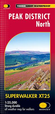
Wandelkaart Peak District Noord | Harvey Maps

0
New, Superwalker XT25 of the Peak District. Revised and re-designed It's got everything! Genuine original HARVEY mapping at 1:25,000. Ideal for walking. Clear, easy to read. Easy to re-fold. Opens directly to either side of the sheet. Slim and flexible. Light to carry. Tearproof and durable. AND, 100% waterproof as standard. The Peak District Nati...

Verkopers met dit product

Verkoper
Bezorging
Prijs
DeZwerver.nl logo
DeZwerver.nl
2,95
24,95

Anderen bekeken ook

Wandelkaart Peak District Central | Harvey Maps
New Superwalker XT25 of the Peak District Revised and re-designed. It's got everything! Genuine original HARVEY mapping at 1:25,000. Ideal for walking. Clear, easy to read. Easy to re-fold. Opens directly to either side of the sheet. Slim and flexible. Light to carry. Tearproof and durable. AND 100% waterproof as standard The Peak District National Park on 3 sheets Peak District Central includes the heart of the Peak District between Sheffield and Manchester. Includes Edale, Kinder Scout, the Gritstone Edges and Ladybower Reservoir
24,95
Wandelkaart Lake District Noord | Harvey Maps
New Superwalker XT25 of the Lake District. Revised and re-designed It's got everything! Genuine original HARVEY mapping at 1:25,000. Clear, easy to read. Easy to re-fold. Opens directly to either side of the sheet. Slim and flexible. Light to carry. Tearproof, durable, AND 100% waterproof as standard - no need for a map case. The Lake District National Park on just 4 sheets. This Lake District North covers the northern fells including Skiddaw, Blencathra, Great Calva Keswick and Derwentwater
24,95
Wandelkaart Peak District Noord | Harvey Maps
HARVEY launch innovative new series: Ultramap XT40. 16 titles featuring in Trail magazine through spring 2016. 40 years experience have gone into HARVEY's most creative new series. The Ultramap covers a large area yet is small enough to slip in a pocket. Actual size 73mm x 152mm. The Ultramap is fully detailed genuine original HARVEY mapping. The Ultramap is tough and 100% waterproof. Use it without a map case, whatever the weather! To provide the biggest area on the smallest lightest sheet, the Ultramap is printed double sided. The ingenious folding pattern allows you to open the Ultramap directly to any part, and either side, of the sheet. The two sides are aligned, so when you reach the edge of the Ultramap sheet you simply flip it over without re-folding. There's an overlap as well, so you can map read continuously. The magic scale of 1:40,000 enables the Ultramap to provide all the detail you would expect to find on a large scale walking map, including rights of way and boundarie…
19,50
Reisboek - Wandelgids Wild Swimming Walks Peak District | Wild Things Publishing
The best-selling Wild Swimming Walks series returns with adventures in Britain's oldest National Park. Ascend to the highest tarns and descend through a valley of secret waterfalls * Walk through woodland gorges carved by cascades * Follow bucolic river valleys dipping as you walk. Wild Swimming Walks Peak Disitrict leads you on 28 adventures in the soaring landscape of the Peak District. Find secret waterfalls, remote lakes and sparkling river pools. Complete with photos, maps and practical guidance, rich in local history and stories, this book will appeal to wild swimmers, family explorers, nature lovers and walkers alike.   JOIN THE ADVENTURE with the best-selling Wild Swimming Walks series and explore Britain’s oldest national park from the gritstone edges of the Hope Valley, to the magical streams on the moorlands of Bleaklow, through to the picturesque limestone river dales of the White Peak.   Scramble up streams and waterfalls at Black Clough Explore fairy pools and mossy…
20,95
Wandelkaart Dark Peak | Harvey Maps
"The 1:40,000 scale used by British Mountain Maps is excellent for hill walking. These maps provide clear, detailed information." Sir Chris Bonington, mountaineer.   Detailed map of the Dark Peak’s famous Moorland Hills and Edges on a single sheet at 1:40,000 scale.   Detailed enlargement of the Kinder plateau. Map extension to Marsden.   As used by Woodhead Mountain Rescue Team.   Tough, durable & 100% waterproof these virtually indestructible maps cover Dark Peak's moorland fells & edges on a single map. Colour shading for easy identification of hill's and valleys makes this the only map you will need to walk in the Peak District. There is also a detailed enlargement of the Kinder plateau on the reverse of the map as well as a geological map. Useful tips, phone numbers etc are also included.
29,95
Wandelgids Day Walks in the Peak District | Vertebrate Publishing
Day Walks in the Peak District - 20 classic circular routes features 20 circular walks, between 8.25 and 12 miles (13 and 19.5 kilometres) in length, suitable for hillwalkers of all abilities. The routes are split into three areas - The High Moors, Hills Tors and Edges and Limestone Country - and feature walks around some of the most wild and beautiful places in the Peak District National Park, including; Alport Castles, Back Tor and Derwent Edge, the Monsal Trail through Chee Dale, the Kinder Edges, Chatsworth, Stanage Moor, The Roaches, Lathkill Dale, Chrome Hill, Cressbrook Dale, Wolfscote Dale and Dove Dale. Researched and written by local hillwalkers, Norman Taylor and Barry Pope, each route features clear and easy to use Ordnance Survey maps, easy-to-follow directions, details of distance, navigation information, refreshment stops and local knowledge.   The book is illustrated with stunning location photography, and also features a detailed Appendix.
20,95
Reisgids Rough Guide Pocket Peak District (Travel Guide with Free EBook) | Rough Guides
Image for Pocket Rough Guide British Breaks Peak District (Travel Guide with Free eBook) Click to enlarge Pocket Rough Guide British Breaks Peak District (Travel Guide with Free eBook) by Rough Guides (Author)   Series:Pocket Rough Guides British Breaks Format:Paperback / softback 152 pages Publisher:APA Publications Imprint:APA Publications ISBN:9781839057885 Published:15 Oct 2022 Classifications:England, Travel & holiday guides Readership:General (US: Trade) Weight:202g Dimensions:100 x 190 x 11 (mm) Pub. Country:United Kingdom Country of Origin:GB Tariff Codes:49019900 For sale in: All countries Description Discover the best of The Peak District with this compact, practical, entertaining Pocket Rough Guide with a free eBook. This slim, trim treasure trove of trustworthy travel information is ideal for travellers on short trips, and covers all the key sights such as Buxton, Castleton and Bakewell, restaurants, shops, cafes and bars, plus inspired ideas for day-trips, with honest ind…
12,50
Wandelkaart Peak District Zuid | Harvey Maps
HARVEY launch innovative new series: Ultramap XT40. 16 titles featuring in Trail magazine through spring 2016. 40 years experience have gone into HARVEY's most creative new series. The Ultramap covers a large area yet is small enough to slip in a pocket. Actual size 73mm x 152mm. The Ultramap is fully detailed genuine original HARVEY mapping. The Ultramap is tough and 100% waterproof. Use it without a map case, whatever the weather! To provide the biggest area on the smallest lightest sheet, the Ultramap is printed double sided. The ingenious folding pattern allows you to open the Ultramap directly to any part, and either side, of the sheet. The two sides are aligned, so when you reach the edge of the Ultramap sheet you simply flip it over without re-folding. There's an overlap as well, so you can map read continuously. The magic scale of 1:40,000 enables the Ultramap to provide all the detail you would expect to find on a large scale walking map, including rights of way and boundarie…
19,50

Klanten-reviews van Wandelkaart Peak District Noord | Harvey Maps

Er zijn nog geen beoordelingen voor dit productBen jij de eerste die een review plaatst?

Meer over Wandelkaart Peak District Noord | Harvey Maps

Productomschrijving

New, Superwalker XT25 of the Peak District. Revised and re-designed It's got everything! Genuine original HARVEY mapping at 1:25,000. Ideal for walking. Clear, easy to read. Easy to re-fold. Opens directly to either side of the sheet. Slim and flexible. Light to carry. Tearproof and durable. AND, 100% waterproof as standard. The Peak District National Park on 3 sheets. PEAK DISTRICT NORTH covers The Dark Peak, including Snake Pass, Bleaklow and Derwent Reservoir and extends north to Saddleworth Moor, Wessenden Moor and Marsden.

Productinformatie

    Verken gerelateerde categorieën

    Webshop.nl maakt gebruik van cookies. Ga je verder op onze website, ga dan akkoord met het plaatsen van cookies en de verwerking van deze data door ons en vermelde partners.