webshop.nl
Categorieën
  Sluiten

Meer Editorial Piolet

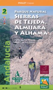
Wandelkaart Parque Natural Sierras de Tejeda, Almijara y Alhama | Edit

0
Een prachtige kaartenset op heel gedetaileerd nivo van de Sierra de Tejeda, opgedeeld in een west en oost gedeelte. Het nationale park igt ten noorden van Nerja, tussen Malaga en Motril.  Alle noodzakelijke details staan er op die je nodig hebt voor het wandelen. Hoogtelijnen, schaduwwerking in de kleuren, ingetekende wandelpaden en routesuggesties...

Webshops met dit product

Webshop
Bezorging
Prijs

Anderen bekeken ook

Wandelkaart Parque Natural Sierras de Tejeda, Almijara y Alhama | Edit
Een prachtige kaartenset op heel gedetaileerd nivo van de Sierra de Tejeda, opgedeeld in een west en oost gedeelte. Het nationale park igt ten noorden van Nerja, tussen Malaga en Motril.  Alle noodzakelijke details staan er op die je nodig hebt voor het wandelen. Hoogtelijnen, schaduwwerking in de kleuren, ingetekende wandelpaden en routesuggesties. Met name in nationale parken en daarom heen in zuidelijk Europa is een geode kaart best handig: er zijn veel ezel- en geitenpaadjes die voor verwarring zorgen.  Van de uitgever Topographic map of the whole 'Natural Park of Sierras de Tejeda, Almijara and Alhama', more than 40,000 hectares of protected area with an impressive natural wealth. The peaks, some over 2,000 m high, are a natural border between the provinces of Granada and Malaga. The rugged and rugged landscapes make this area an ideal place for hiking enthusiasts of all levels. From a cultural point of view, Muslim heritage is present throughout the territory, with whitewashed vi…
19,95
Wandelkaart - Topografische kaart 149 OS Explorer Map Sittingbourne, F
Explore the serene Isle of Sheppey and follow the Saxon Shore Way to discover the towns of Sittingbourne and Faversham. Further inland, the Kent Downs – an Area of Outstanding Natural Beauty – are beckoning.  Sail, kayak, fly kites or just relax on the sandy and pebbled beaches of Sheppey, or go birdwatching at the Swale National Nature Reserve  Discover Faversham, home of Britain’s oldest brewer and nearby Oare Gunpowder Works Country Park, where gunpowder was manufactured for the battles of Trafalgar and Waterloo  Walk, ramble or cycle along the Saxon Shore Way through Faversham and Sittingbourne, or head inland to the North Downs Way, a National Trail Met zijn 4cm voor 1 km (2 ½ cm voor 1 mijl) schaal, is de OS Explorer kaartenserie de ideale en meest gedetailleerde kaartenreeks voor mensen die graag outdoor-activiteiten zoals fietsen, wandelen, paardrijden, klimmen en watersporten. Deze kaart is nog gedetailleerder dan de 'gewone' Landranger maps. Voor- en achterzijde bedrukt! Z…
19,50
Wandelgids Spanish Trails - Los picos de Europa | Spanish Trails
Handzaam wandelgidsje met 34 wandelingen in de Picos de Europa met schetsmatige kaartjes. In this book Phil Lawler offers a wide selection of walks across the Picos de Europa in the majestic Cordillera Cantábrica, the Cantabrian Mountains, which run parallel with the Atlantic coastline in northern Spain. Phil has an intimate knowledge of this beautiful mountain range, as well as mountains in other parts of Spain. Many of the walks offer a choice of options and all are graded, with clear and concise information and useful tips. This handy and practical guide also indicates where you can find watering holes, as well as where to stay overnight and where to park your car. From an easy or moderate walk to a more strenuous and challenging ascent, there is something here for everyone. This is the first in a series of guides which will cover the Sierra Almijara and Tejeda in Andalucia, the Sierra de Guadarrama near Madrid, the natural park of Cazorla and the Ordesa area of the Pyrenees.
16,50
Wandelkaart - Topografische kaart 149 OS Explorer Map Sittingbourne, F
Explore the serene Isle of Sheppey and follow the Saxon Shore Way to discover the towns of Sittingbourne and Faversham. Further inland, the Kent Downs – an Area of Outstanding Natural Beauty – are beckoning.  Sail, kayak, fly kites or just relax on the sandy and pebbled beaches of Sheppey, or go birdwatching at the Swale National Nature Reserve  Discover Faversham, home of Britain’s oldest brewer and nearby Oare Gunpowder Works Country Park, where gunpowder was manufactured for the battles of Trafalgar and Waterloo  Walk, ramble or cycle along the Saxon Shore Way through Faversham and Sittingbourne, or head inland to the North Downs Way, a National Trail Met zijn 4cm voor 1 km (2 ½ cm voor 1 mijl) schaal, is de OS Explorer kaartenserie de ideale en meest gedetailleerde kaartenreeks voor mensen die graag outdoor-activiteiten zoals fietsen, wandelen, paardrijden, klimmen en watersporten. Deze kaart is nog gedetailleerder dan de 'gewone' Landranger maps. Voor- en achterzijde bedrukt! Z…
19,50
Wandelkaart - Topografische kaart 146 OS Explorer Map Dorking, Box Hil
Unearth the rich history and pastoral charms of the Surrey Hills, an Area of Outstanding Natural Beauty, and visit the historic market towns of Dorking, Leatherhead, Reigate and Caterham. Climb Box Hill, the world’s favourite cyclist hill climb, for stunning views of the North Downs.    Marvel at the 18th-century landscape park of Painshill, the Edwardian charm of Polesden Lacey and Reigate’s medieval castle  Spot Adonis blue butterflies and bee orchids, picnic by the Stepping Stones or climb Box Hill for its sensational vistas of the North Downs and High Weald  Ramble, hike and cycle along paths including the North Downs Way, Greensand Way and Mole Gap Trail    Met zijn 4cm voor 1 km (2 ½ cm voor 1 mijl) schaal, is de OS Explorer kaartenserie de ideale en meest gedetailleerde kaartenreeks voor mensen die graag outdoor-activiteiten zoals fietsen, wandelen, paardrijden, klimmen en watersporten. Deze kaart is nog gedetailleerder dan de 'gewone' Landranger maps. Voor- en achterzijde be…
19,50
Wandelkaart - Topografische kaart 171 OS Explorer Map Chiltern Hills W
Plunge into lovely countryside as you explore the west Chiltern Hills, an Area of Outstanding Natural Beauty on London’s doorstep. Roam hills clothed in ancient woods and chalk-fed streams, then refresh yourself in the historic market towns of Henley-on-Thames and Wallingford, home of Agatha Christie.    Enjoy Henley-on-Thames, a quintessentially English town set along an exceptionally beautiful stretch of the River Thames  Experience the unique chalk landscape of the Chilterns and glimpse rare butterflies, birds of prey and orchids  Walk or cycle beloved recreational paths including the Chiltern Way, Oxfordshire Way and a section of the ancient Ridgeway, Britain’s oldest road  Met zijn 4cm voor 1 km (2 ½ cm voor 1 mijl) schaal, is de OS Explorer kaartenserie de ideale en meest gedetailleerde kaartenreeks voor mensen die graag outdoor-activiteiten zoals fietsen, wandelen, paardrijden, klimmen en watersporten. Deze kaart is nog gedetailleerder dan de 'gewone' Landranger maps. Voor- e…
19,50
Wandelkaart - Topografische kaart 124 OS Explorer Map Hastings & Bexhi
Experience the history-rich countryside where the High Weald, an Area of Outstanding Natural Beauty, sweeps down to the shore where the fate of Britain was decided in 1066. Explore Battle and visit the actual spot where the Battle of Hastings took place, now a beautiful wildflower meadow dotted with the ruins of a grand abbey built in penance for the slaughter.  Visit the seaside towns of Hastings and Bexhill with their medieval Old Towns, Victorian and Edwardian seafronts and pavilions  Glimpse wild deer and boar roaming in the forests near Robertsbridge and Dartwell Reservoir in the High Weald  Walk or cycle in the footsteps of William the Conqueror on the 1066 Path, or start the Saxon Shore Way from Hastings to head north to Winchelsea  Met zijn 4cm voor 1 km (2 ½ cm voor 1 mijl) schaal, is de OS Explorer kaartenserie de ideale en meest gedetailleerde kaartenreeks voor mensen die graag outdoor-activiteiten zoals fietsen, wandelen, paardrijden, klimmen en watersporten. Deze kaart …
19,50
Wandelkaart - Topografische kaart 171 OS Explorer Map Chiltern Hills W
Plunge into lovely countryside as you explore the west Chiltern Hills, an Area of Outstanding Natural Beauty on London’s doorstep. Roam hills clothed in ancient woods and chalk-fed streams, then refresh yourself in the historic market towns of Henley-on-Thames and Wallingford, home of Agatha Christie.    Enjoy Henley-on-Thames, a quintessentially English town set along an exceptionally beautiful stretch of the River Thames  Experience the unique chalk landscape of the Chilterns and glimpse rare butterflies, birds of prey and orchids  Walk or cycle beloved recreational paths including the Chiltern Way, Oxfordshire Way and a section of the ancient Ridgeway, Britain’s oldest road  Met zijn 4cm voor 1 km (2 ½ cm voor 1 mijl) schaal, is de OS Explorer kaartenserie de ideale en meest gedetailleerde kaartenreeks voor mensen die graag outdoor-activiteiten zoals fietsen, wandelen, paardrijden, klimmen en watersporten. Deze kaart is nog gedetailleerder dan de 'gewone' Landranger maps. Voor- e…
19,50

Klanten-reviews van Wandelkaart Parque Natural Sierras de Tejeda, Almijara y Alhama | Edit

Er zijn nog geen beoordelingen voor dit productBen jij de eerste die een review plaatst?

Meer over Wandelkaart Parque Natural Sierras de Tejeda, Almijara y Alhama | Edit

Productomschrijving

Een prachtige kaartenset op heel gedetaileerd nivo van de Sierra de Tejeda, opgedeeld in een west en oost gedeelte. Het nationale park igt ten noorden van Nerja, tussen Malaga en Motril.  Alle noodzakelijke details staan er op die je nodig hebt voor het wandelen. Hoogtelijnen, schaduwwerking in de kleuren, ingetekende wandelpaden en routesuggesties. Met name in nationale parken en daarom heen in zuidelijk Europa is een geode kaart best handig: er zijn veel ezel- en geitenpaadjes die voor verwarring zorgen.  Van de uitgever Topographic map of the whole 'Natural Park of Sierras de Tejeda, Almijara and Alhama', more than 40,000 hectares of protected area with an impressive natural wealth. The peaks, some over 2,000 m high, are a natural border between the provinces of Granada and Malaga. The rugged and rugged landscapes make this area an ideal place for hiking enthusiasts of all levels. From a cultural point of view, Muslim heritage is present throughout the territory, with whitewashed villages scattered throughout the area. It should be noted Salares, which with its Minaret Tower, is an architectural jewel.   The cartography of these saws is presented in two sheets at 1: 25,000 scale where all the routes of the Natural Park, the long and small routes and a proposal of 34 itineraries that will allow to know in depth all the corners of the park have been represented. The legend of the map is translated into 4 languages and the presentation of this publication in the form of a folder with a completely renovated design makes today an excellent tool to get to know the park.

Productspecificaties

Artikelnummer(s)
Brand
Editorial Piolet
Webshop.nl maakt gebruik van cookies. Ga je verder op onze website, ga dan akkoord met het plaatsen van cookies en de verwerking van deze data door ons en vermelde partners.