webshop.nl

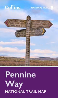
Wandelkaart National Trail Map Pennine Way | Collins

0
Overzichtskaart op vrij grove schaal van deze LAW Lange Afstands Wandeling in Engeland. Let op: je kunt er niet op lopen. Wel met veel informatie op de kaart, goed ingetekend, een route-schema op de achterzijde en een beschrijving van een aantal bezienswaardigheden.  Perfect guide and map for planning your adventure along the iconic Pennine Way.  ...

Webshops met dit product

Webshop
Bezorging
Prijs
DeZwerver.nl logo
DeZwerver.nl
niet bekend
11,50

Anderen bekeken ook

Wandelkaart National Trail Map South Downs Way | Collins
Overzichtskaart op vrij grove schaal van deze LAW Lange Afstands Wandeling in Engeland. Wel met veel informatie op de kaart, goed ingetekend, een route-schema op de achterzijde en een beschrijving van een aantal bezienswaardigheden. ALs je voor lichtgewicht gaat, is dit al vrijwel voldoende om met de bewegwijzering ter plekke de route te kunnen lopen. Perfect guide and map for planning your adventure along the South Downs Way.   Highlights of this Planning Map include:   More than 20 highlighted places of interest with detailed descriptions and attractive photographs, including: Brighton Pier, The Long Man of Wilmington, and Seven Sisters A comprehensive index to more than 800 cities, towns and villages A clear, visible route plotted across a 2 miles to 1 inch ( 1.25 km to 1 cm) scale map Advice on safety and security when travelling along the route, as well as the countryside code and the code of conduct Part of the National Trail network, this long distance footpath covers 100 miles…
11,50
Wandelkaart National Trail Map Peddars Way and Norfolk Coast | Collins
Overzichtskaart op vrij grove schaal van deze LAW Lange Afstands Wandeling in Engeland. Let op: je kunt er niet op lopen. Wel met veel informatie op de kaart, goed ingetekend, een route-schema op de achterzijde en een beschrijving van een aantal bezienswaardigheden.  Perfect guide and map for planning your adventure along Peddar’s Way and the Norfolk Coast Path. This incorporates part of the newly formed England Coast Path.   Highlights of this Planning Map include:   More than 20 highlighted places of interest with detailed descriptions and attractive photographs, including: the Hunstanton striped cliffs, Blakeney Point, and Binham Priory A comprehensive index to more than 600 cities, towns and villages A clear, visible route plotted across a 2.4 miles to 1 inch (1.5 km to 1 cm) scale map Advice on safety and security when travelling along the route, as well as the countryside code and the code of conduct Part of the National Trail network, these two long-distance footpaths cover 93 …
11,50
Wandelkaart National Trail Map Hadrian's Wall Path | Collins
Overzichtskaart op vrij grove schaal van deze LAW Lange Afstands Wandeling in Engeland. Let op: je kunt er niet op lopen. Wel met veel informatie op de kaart, goed ingetekend, een route-schema op de achterzijde en een beschrijving van een aantal bezienswaardigheden.  Perfect guide and map for planning your adventure along Hadrian’s Wall.   Highlights of this Planning Map include:   More than 20 highlighted places of interest with detailed descriptions and attractive photographs, including: the Vindolanda archaeological site, Chester’s Roman fort, and Steel Rigg viewpoint. A comprehensive index to more than 400 cities, towns and villages A clear, visible route plotted across the map Advice on safety and security when travelling along the route, as well as the countryside code and the code of conduct Part of the National Trail network, this long-distance footpath covers 84 miles (135 km) along the line of Hadrian's Wall from coast-to-coast. Starting in Wallsend in Newcastle and ending i…
11,50
Wandelkaart National Trail Map Thames Path | Collins
Overzichtskaart op vrij grove schaal van deze LAW Lange Afstands Wandeling in Engeland. Let op: je kunt er niet op lopen. Wel met veel informatie op de kaart, goed ingetekend, een route-schema op de achterzijde en een beschrijving van een aantal bezienswaardigheden.  Highlights of this Planning Map include:   More than 20 highlighted places of interest with detailed descriptions and attractive photographs, including: Tower Bridge, Hampton Court Palace, and Kew Gardens A comprehensive index to more than 800 cities, towns and villages A clear, visible route plotted across the map Advice on safety and security when travelling along the route, as well as the countryside code and the code of conduct Part of the National Trail network, this long distance footpath covers 184 miles (296 km) and follows the length of England’s longest river, the Thames, from its source in the Cotswolds to the Thames Barrier in Greenwich, London. A suggested walking itinerary makes it easy for users to plan the…
11,50
Wandelkaart Pennine Way South | Harvey Maps
Mooie, duidelijke kaart van het zuidelijke gedeelte van de Pennine Way (Edale to Middleton-in-Teesdale). The whole of the Pennine Way on just 2 maps!   Pennine Way South map covers the route from Edale to Middleton-in-Teesdale.   The Pennine Way is a National Trail. It follows the backbone of England from the Peak District to the Scottish borders. It is one of the toughest UK long distance footpaths, and forms part of the European Footpath Network.   The Pennine Way was Britain's first National Trail, opened in 1965.   Just 2 HARVEY maps cover the whole 431km (268 miles) route. Each starts and finishes near public transport, so no hassle with getting lifts.   Each map also contains lots of information and useful telephone numbers to assist the walker with planning.   Tough, light, durable and 100% waterproof Includes Rights of Way Genuine original HARVEY mapping Route clearly marked  
28,50
Fietskaart Cycle Map Pennine Cycleway South | Sustrans
The official route map for the 136-mile (219km) southern part of the Pennine Cycleway on National Cycle Network Route 68 from Derby to Settle.   This linear map shows the route and immediate surrounding area over a series of separate map panels. The full colour map based on Ordnance Survey data shows clearly mapped cycle routes on traffic-free paths, quiet lanes and roads, with easy to read contours, route profiles and mile markers. Also features detailed inset maps for the major towns and cities, tourist info and cycle shop and hire information, and other local routes.   The southern half of the Pennine Cycleway is a beautiful, yet challenging ride which takes you through the dramatic scenery of the Peak District and the South Pennines. The route takes you from the bustling railway city of Derby to the historic town of Settle, taking in the famous spa town of Buxton and the lovely Yorkshire town of Holmfirth, renowned location of the TV classic “Last of the Summer Wine”.   This secti…
13,50
Wandelkaart Pennine Way North | Harvey Maps
Mooie, duidelijke kaart van het Noordelijke gedeelte van de Pennine Way (Middleton-in-Teesdale naar Kirk Yetholm). The whole of the Pennine Way on just 2 maps!   Pennine Way North map covers the route from Middleton-in-Teesdale to Kirk Yetholm.   The Pennine Way is a National Trail. It follows the backbone of England from the Peak District to the Scottish borders. It is one of the toughest UK long distance footpaths, and forms part of the European Footpath Network.   The Pennine Way was Britain's first National Trail, opened in 1965.   Just 2 HARVEY maps cover the whole 431km (268 miles) route. Each starts and finishes near public transport, so no hassle with getting lifts.   Each map also contains lots of information and useful telephone numbers to assist the walker with planning.   Tough, light, durable and 100% waterproof Includes Rights of Way Genuine original HARVEY mapping Route clearly marked  
28,50
Wegenkaart - landkaart National Park Pocket Map Peak District | Collins
Handige kleine kaart van dit Nationaal Park. De kaart geeft een goed en helder overzicht van het gebied met alle plaatsen, doorgaande wandelpaden (alhoewel grof van schaal), bezienswaardigheden etc. Met een register en aanvullende tekst onder de kaart is het een mooi overzicht wat je waar kunt gaan doen. Handy little full colour map of Peak District National Park. Detailed mapping and visitor information to the National Park along with a selection of photographs. Map at a scale of 1:120 000 (1cm to 1.20km, 1.9 miles to 1 inch).This small map gives a great overview of the Peak District National Park, and is the perfect companion for exploring this beautiful area of England.• Clear, detailed mapping• Key park, tourist and travel information• Ideal for planning visits to the National Park• Index to help locate and plan your trip• Information on the Pennine Way, Stanage-North Lees, caving activities and other places of interest  
7,95
Wandelkaart Tour des Combins trekking map | Knife Edge Outdoor
The best sheet map for the Tour des Combins. Displays the entire route and variants on a single sheet: perfect for planning and navigation.       1:40,000 - larger scale and more detail than any other map.       Made specifically for the Tour des Combins by Knife Edge Outdoor Guidebooks:       English/French/German map key 1:40,000 Numerous variants Includes free GPX downloads for the trail GPS compatible Tougher than traditional maps: try to tear it! More water-resistant than traditional maps Lighter than traditional maps Huts/accommodation marked on the map     The Tour des Combins is an epic trek in the Swiss and Italian Alps. It traverses some of Europe's wildest mountain terrain. The sublime scenery makes it a worthy alternative to the more famous Tour du Mont Blanc (which is only a stone's throw away).       Hike along the edge of the Corbassière Glacier, one of the longest in Europe. Enjoy snow frosted summits, magnificent valleys and pastures, sparkling azure lakes, carpets of…
23,90
Wegenkaart - landkaart North Coast Road Trip Map | Destination Earth
This North Coast road trip map is the essential tool that will guide you through the breathtaking landscapes, stunning coastal views, and enchanting villages of the North Coast 500 in Scotland. Designed by travel enthusiasts, for travel enthusiasts, our map is more than just a navigation tool. It's a gateway to adventure, a treasure trove of hidden gems, and a companion that will make your journey even more extraordinary. Featuring a detailed and easy-to-read layout, this Destination NC500 Map will assist you in planning and navigating your way along the 500-mile route. With precise mile markers, highlighted attractions, and recommended stopping points, this map will ensure you don't miss a single sight along the way.   NC500 A1 Map Features:     Exact Locations: All of the exact locations of over 110+ Sights and Attractions, as well as Accommodation, Restaurants, Campervan Water and Waste Facilities, Electric Vehicle Charging Points, Train Stations, Airports, and much more! Must-know…
13,-

Klanten-reviews van Wandelkaart National Trail Map Pennine Way | Collins

Er zijn nog geen beoordelingen voor dit productBen jij de eerste die een review plaatst?

Meer over Wandelkaart National Trail Map Pennine Way | Collins

Productomschrijving

Overzichtskaart op vrij grove schaal van deze LAW Lange Afstands Wandeling in Engeland. Let op: je kunt er niet op lopen. Wel met veel informatie op de kaart, goed ingetekend, een route-schema op de achterzijde en een beschrijving van een aantal bezienswaardigheden. 

Perfect guide and map for planning your adventure along the iconic Pennine Way.   Highlights of this Planning Map include:   More than 20 highlighted places of interest with detailed descriptions and attractive photographs, including: Hadrian’s Wall, Tan Hill, and Cauldron Snout A comprehensive index to more than 1000 cities, towns and villages A clear, visible route plotted across the map Advice on safety and security when travelling along the route, as well as the countryside code and the code of conduct The Pennine Way is the oldest of the 16 National Trails and runs along The Pennines, linking the Peak District National Park with the Cheviot Hills. Starting in Edale, Derbyshire, the walk covers 268 miles (431 km) and passes through the Yorkshire Dales to finish in Kirk Yetholm, just inside the Scottish Borders. A suggested walking itinerary makes it easy for users to plan their journey along this popular route.

Verken gerelateerde categorieën

Webshop.nl maakt gebruik van cookies. Ga je verder op onze website, ga dan akkoord met het plaatsen van cookies en de verwerking van deze data door ons en vermelde partners.