webshop.nl

Wandelkaart Munro and Corbett Chart | Harvey Maps

0
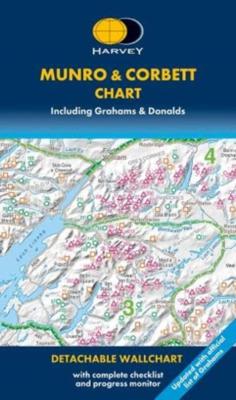
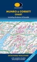
Alle Munro's en Corbetts op 1 kaart!  First published in 1996 this current edition of our best selling chart used for monitoring and recording your progress in completing the Munros and Corbetts has been brought up to date to include the height revisions of 2009 and 2011 according to the Munro Society. It also includes the Grahams and the Donalds....

Webshops met dit product

Webshop
Bezorging
Prijs
DeZwerver.nl logo
DeZwerver.nl
niet bekend
17,95

Anderen bekeken ook

Wandelkaart Ben Nevis | Harvey Maps
Een bijzonder mooie en handige kaart van dit prachtige bergachtige gebied. Op waterafstotend papier met veel details. HARVEY Superwalker map at 1:25,000 scale Detailed map of Ben Nevis for walkers and climbers This map for hillwalkers covers Fort William through Glen Nevis to Loch Treig. From the Grey Corries south to Kinlochleven. Ben Nevis, the Aonachs and the Mamores are among the 20 Munros and 4 Corbetts. Clear and easy to read with all the detail needed for ascending Britain's highest mountain. Enlargement of Ben Nevis summit showing the safety bearings in case of a descent in bad weather. As used by the Lochaber Mountain Rescue Team.
24,95
Wandelkaart Hadrian's Wall | Harvey Maps
Een bijzonder handige kaart van dit lange-afstands-wandelpad. Op waterafstotend papier met veel details. Het enige dat je eigenlijk een beetje mist is een overzicht. Verder uitstekend en voldoende voor de route. Compact and light - the map itself weighs just 60gms - a third of the weight of a laminated map, and much less bulky. And you can fold or refold it time and again, or stuff it in your back pocket and it won't fall to pieces. Entire route on one map. 130km (81 miles) from the Solway Coast to Newcastle. Opportunity to visit a large number of historical sites along the way. Information on finding accommodation, camping, food. Directions to the start. Also Ranger Service contact numbers and enlargements of towns/villages showing facilities available and tips on weather and clothing Detailed mapping, full legend. National Grid - can be used with GPS. 1:40,000 scale. Waterproof. Supplied in clear plastic pocket
25,95
Wandelkaart Settle to Carlisle Way | Harvey Maps
Mooie, duidelijke kaart van de Settle to Carlisle Way in Noord-Engeland. Geplastificeerd met veel extra informatie en uitsnedes van de route. Settle Carlisle Way is a walking route linking the stations of the famous and scenic Settle-Carlisle Railway Line. This map gives you the chance to walk up and ride back on the train, or to hop off at one station and rejoin a later train further on. The route starts in picturesque Settle and passes through the beautiful Yorkshire Dales and the sheltered Eden Valley, ending in central Carlisle. The entire route is on the one map. Tough and 100% waterproof Compact and light - the map itself weighs just 60gms - a third of the weight of a laminated map, and much less bulky. And you can fold or refold it time and again, or stuff it in your pocket and it won't fall to pieces. Shows the entire route on one sheet. Information on finding accommodation, camping, food. Directions to the start. Also Ranger Service contact numbers and enlargements of towns/v…
21,50
Wandelkaart Cape Wrath Trail South | Harvey Maps
Een bijzonder handige kaart van dit lange-afstands-wandelpad. Op waterafstotend papier met veel details. Het enige dat je eigenlijk een beetje mist is een overzicht. Verder uitstekend en voldoende voor de route. XT40 - Leap forward in technical excellence. Tough, light and 100% waterproof   Compact and light - the map itself weighs just 60gms - a third of the weight of a laminated map, and much less bulky. And you can fold or refold it time and again, or stuff it in your back pocket and it won't fall to pieces. Shows the entire route on one sheet.   The Cape Wrath Trail is a challenging route from Fort William to Cape Wrath. It is around 200 miles long and passes through some of Scotland's wildest and most spectacular scenery.   This map covers the southern section of the route, from Fort William to Strathcarron.   The trail has evolved from use and is not an officially recognised National Trail. There is no single definitive route. There are various ways of tackling the traverse all …
28,50
Wandelkaart Cleveland Way | Harvey Maps
Mooie, duidelijke kaart van de Cleveland Way in Noord-Engeland. Geplastificeerd met veel extra informatie en uitsnedes van de route.    Leap forward in technical excellence. Tough, light and 100% waterproof Compact and light - the map itself weighs just 60gms - a third of the weight of a laminated map, and much less bulky. And you can fold or refold it time and again, or stuff it in your back pocket and it won't fall to pieces. Shows the entire route on one sheet.   174km (109 miles) from Helmsley across the North York Moors National Park to Saltburn and along the coast via Scarborough ending at Filey.   Information on finding accommodation, camping, food. Directions to the start. Also Ranger Service contact numbers and enlargements of towns/villages showing facilities available and tips on weather and clothing.   Detailed mapping, full legend. National Grid - can be used with GPS. 1:40,000 scale. Waterproof. Supplied in clear plastic pocket
25,95
Wandelkaart A15 Sarrabus da Costa Rei a Porto Corallo | Abies
Sarrabus is a territory that is not known by everybody yet. Here lies its charm and this has made possible to keep this environmental area out of big building speculations and also out of history. In fact it preserves little traces of the past, and paradoxically the remains from the prehistoric age are more meaningful than those back to more recent times. We can find traces from the most remote past not far from the State Road SS125, that from Muravera goes to Costa Rei, by visiting the nuraghe Murtas, the nuraghe S’Aqua Secis and the megalithic complexes of Scalas and Cuili Piras. They are about ten menhirs, almost fully intact, arranged in groups and fixed in the ground in the original orthostatic position. They have been put in relation with the position of the sun and the moon, at dawn and at sunset. In fact they were used as a very precise astronomic calendar but also for religious purposes since they represented both the masculine divinity and the fertility according to the wors…
12,95
Wandelkaart Glyndwr's Way | Harvey Maps
XT40. Leap forward in technical excellence. Tough, light and 100% waterproof   Compact and light - the map itself weighs just 60gms - a third of the weight of a laminated map, and much less bulky. And you can fold or refold it time and again, or stuff it in your back pocket and it won't fall to pieces. Shows the entire route on one sheet.   Glyndwr's Way is a 217km (135 mile) long National Trail meandering through the open moorland, rolling farmland, woodland and forest of mid-Wales. The Way starts at Knighton and ends in Welshpool. It takes you to some of the finest landscape features in Wales including the tranquil Radnorshire Hills, the shores of the Clywedog Reservoir and heather clad Plynlimon. There are also spectacular views over Cadair Idris, Lake Vyrnwy, the Cambrian mountains and Y Golfa. The highest point on the route is Foel Fadian at 510m (1530ft).    The map is arranged in panels so that at any one time you only have to have the part you need open. It is supplied folded…
25,95
Wandelkaart Arran including Arran Coastal Way | Harvey Maps
Een bijzonder handige kaart van dit gebied. Op waterafstotend papier met veel details.    Features the renowned Goat Fell, A'Chir ridge, Beinn Bharrain, Glen Sannox & Glen Rosa. Detailed map for hillwalkers of the whole island at the popular 1:25,000 scale. The 100km (62 miles) Arran Coastal Way is also shown. The route links the coastline of the island with the villages and the stunning scenery Arran has to offer. Includes Gaelic-English glossary and information on local archaeological and historical sites. Landscape and wildlife information from the National Trust for Scotland Includes 4 Corbetts and 1 Graham.   Tough, light, durable and 100% waterproof Genuine, original, HARVEY mapping Opens directly to either side of the sheet Easy to re-fold  
24,95
Wandelkaart Speyside Walk (Schotland) | Harvey Maps
Een bijzonder handige kaart van dit lange-afstands-wandelpad van 144 km. Op waterafstotend papier met veel details, uitstekend en voldoende voor deze route. A leap forward in technical excellence: Tough, durable and 100% waterproof - virtually indestructible in normal use. Compact and light - the map itself weighs just 60gms - a third of the weight of a bulky laminated map. You can fold or refold it time and again, or stuff it in your back pocket and it won't fall to pieces. Shows the entire route on one sheet. 144km (90 miles) from Aviemore to Buckie, via Nethybridge, Grantown and Fochabers, with a spur to Tomintoul. 
25,95

Klanten-reviews van Wandelkaart Munro and Corbett Chart | Harvey Maps

Er zijn nog geen beoordelingen voor dit productBen jij de eerste die een review plaatst?

Meer over Wandelkaart Munro and Corbett Chart | Harvey Maps

Productomschrijving

Alle Munro's en Corbetts op 1 kaart! 

First published in 1996 this current edition of our best selling chart used for monitoring and recording your progress in completing the Munros and Corbetts has been brought up to date to include the height revisions of 2009 and 2011 according to the Munro Society.

It also includes the Grahams and the Donalds. It can be removed from the cover without damage and wall mounted. Based on the 1997 edition of Munro's Tables progress can be monitored filling in the targets or the symbols on the map and by recording the date of each ascent. The symbols have been updated to make them easier to read, and can now be identified clearly by the colour blind.

This Munro map is a chart which shows and lists all Munros (mountains over 3000ft), Corbetts (over 2500ft), Grahams and Donalds (over 2000ft). A selection of other hills are named for information.   Size 880x1145mm.   Space for recording your date of ascent.   Target to fill in as you complete the challenge.

Verken gerelateerde categorieën

Webshop.nl maakt gebruik van cookies. Ga je verder op onze website, ga dan akkoord met het plaatsen van cookies en de verwerking van deze data door ons en vermelde partners.