webshop.nl
Categorieën
  Sluiten

Meer Harvey Maps
Meer Harvey Maps in Auto-onderdelen

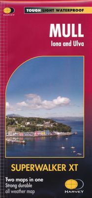
Wandelkaart Mull - Iona - Ulva | Harvey Maps

Zeer duidelijke kaart van Mull, met o.a. hoogtelijnen en geschikt voor gebruik met GPS.Two maps in one!   1:25,000 scale walking map of the mountains of Mull with a recreation map of the whole island on the reverse at 1:55,000   Map enlargement of Iona at 1:25,000 scale   Includes 1 Munro, 1 Corbett and 7 Grahams.   Tough, light, durable and 100% w...
25,95

Webshops met dit product

Webshop
Bezorging
Prijs

Anderen bekeken ook

Wandelkaart Mourne Mountains | Harvey Maps
The Mournes, a granite mountain range in County Down, includes the highest mountains in Northern Ireland. The highest is Slieve Donard at 850 metres.   Detailed map for hillwalkers of the Mountains of Mourne at 1:25,000 scale.   The Mournes is an Area of Outstanding Natural Beauty and has been proposed as the first national park in Northern Ireland. The area is partly owned by the National Trust and sees a large number of visitors every year.   The Mourne Wall is among the more famous features in the Mournes. It is a 35km (22mls) drystone wall that crosses fifteen summits, constructed in 1904 and completed in 1922 to define the boundaries of land purchased by the Belfast Water Commissioners in the late 1800s.   Includes The Mourne Way Long Distance Footpath.   Scale: 1:25,000 Ratio: 4cm = 1km Flat size: 696 x 486mm Folded size: 116 x 243mm Weight: 33gms Area of mapping: 353sqkm Double sided
24,95
Wandelkaart Loch Lomond & The Trossachs | Harvey Maps
Detailed Superwalker map for walkers of Loch Lomond & the Trossachs National Park at 1:25,000 scale. Includes Scotland?s most southerly Munro, Ben Lomond and an inset map for access to Ben Vorlich from Loch Earn. Ideal for The Great Trossachs Forest, Loch Katrine, Ben Ledi & Queen Elizabeth Forest Park. Includes 7 Munros, 7 Corbetts and 6 Grahams. Tough, light, durable and 100% waterproof Genuine, original, HARVEY mapping Opens directly to either side of the sheet Easy to re-fold
24,95
Wandelkaart Skye The Cuillin | Harvey Maps
New Revised Edition and Format. More than a map, an essential piece of equipment this new generation HARVEY Superwalker is designed to be the most practical tool for navigation outdoors. The format gives more mapping on the sheet without making the map heavy and bulky. The fold has been developed to allow you to open directly to any part and either side of the sheet easily. No more struggling in the wind. The Superwalker XT25 is based on original HARVEY mapping with all the information a walker would expect on a map at 1:25,000 scale. Walls and fences on farmland are now shown. The clarity of the mapping has been improved to enable more people to read it without their glasses. The map is uncluttered by information irrelevant to the walker. The precise contouring and delicate hill shading give an immediate picture of the ground. Experience the satisfaction of fine navigation with the Superwalker XT25, now printed on our 100% waterproof and almost indestructible paper, whatever the weath…
24,95

Klanten-reviews van Wandelkaart Mull - Iona - Ulva | Harvey Maps

Er zijn nog geen beoordelingen voor dit productBen jij de eerste die een review plaatst?

Meer over Wandelkaart Mull - Iona - Ulva | Harvey Maps

Productomschrijving

Zeer duidelijke kaart van Mull, met o.a. hoogtelijnen en geschikt voor gebruik met GPS.Two maps in one!   1:25,000 scale walking map of the mountains of Mull with a recreation map of the whole island on the reverse at 1:55,000   Map enlargement of Iona at 1:25,000 scale   Includes 1 Munro, 1 Corbett and 7 Grahams.   Tough, light, durable and 100% waterproof Genuine, original, HARVEY mapping Easy to re-fold

Productspecificaties

Artikelnummer(s)
Brand
Harvey Maps

Verken gerelateerde categorieën

Webshop.nl maakt gebruik van cookies. Ga je verder op onze website, ga dan akkoord met het plaatsen van cookies en de verwerking van deze data door ons en vermelde partners.