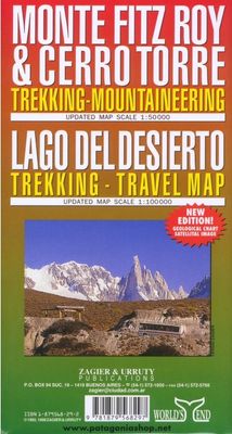
Wandelkaart Monte Fitz Roy - Cerro Torre - Lago del Desierto | Zagier & Urruty

0
Wandelkaart van het fascinerende Fitz Roy massif. Ideale kaart voor trekkings in de regio. Fitz Roy en Cerro Torre in schaal 50.000 en Lago del Desierto in 100.000 Trekking and mountaineering map based on aerophotography. Relief, contours forms, glaciers, woods, camping and trails. Geological chart and landsat image. Includes Lago del Desierto and...

Verkopers met dit product

Verkoper
Bezorging
Prijs
DeZwerver.nl logo
DeZwerver.nl
2,95
17,95

Anderen bekeken ook

Wegenkaart - landkaart Parque Nacional los Glaciares | Zagier & Urruty
LOS GLACIARES NATIONAL PARK ECOMAP The most incredible Park of Patagonia, including Perito Moreno Glacier and Mount Fitz Roy. Satellite relief, roads, navigation, camping, inns and estancias, etc. El Parque mas espectacular de la Patagonia, donde sobresalen el Glaciar Perito Moreno y el Monte Fitz Roy. Rutas, navegaciones, estancias turisticas, paradores, camping, etc. Spanish / English edition. Southern Patagonia’s main National Park, Los Glaciares, with the world's only advancing glacier. The map uses satellite imagery, enhanced with colours and hill-shading to give a vivid representation of the relief. Many local peaks, glaciers and other geographical features are marked and named. Road network includes unpaved roads and dirt tracks, with locations of petrol stations and intermediate driving distances. Ferry connections on the region’s numerous lakes are also indicated. Symbols highlight accommodation and restaurant facilites. Latitude and longitude lines are drawn at 15' intervals…
17,95
Wandelkaart 102 Gardasee - Lago di Garda - Lake Garda | Kompass
Goede wandelkaart van omgeving Gardameer met vrijwel alle topografische details als hoogtelijnen, vegetatie, schaduwtekening maar ook de ingetekende wandelroutes en in veel gevallen ook fietsroutes (MTB). Gevaarlijke routes worden als zodanig weergegeven met een bepaalde markering. Berghutten en campings zijn goed terug te vinden op deze kaarten.   Daarnaast staan de toeristische bezienswaardigheden met symbolen vermeld. Kleurgebruik kan soms vrij fel overkomen, daardoor oogt deze detailkaart wellicht wat druk, maar het blijft een goed leesbare kaart. Sommige kaarten zijn geplastificeerd, maar helaas niet allemaal. De graden staan aan de zijkanten van de kaart, daardoor te gebruiken voor GPS.   Met Aktiv guide: een boekje met wandelroutes.   Steden/dorpen/gebieden: Condino, Riva del Garda, Storo, Limone sul Garda, Malcesine, Gargano, Toscolano-Maderno, Torri del Benaco, Brentino-Belluno, Caprino Veronese, Salo (Salò), Garda, Lazise, Desenzano del Garda, Peschiera del Garda   Bergen/da…
16,95
Wandelkaart Gran Paradiso National Park | Fraternali Editore
Officiele wandelkaart van het Nationaal park Gran Paradiso op schaal 1:25.000. For the realization of this paper map, hundreds of km has been walked on streets and paths, recording routes with gps technology This job technique allows us to obtain a precise collocation of all the useful elements for a hiker. The paper is based on the creation of a complete geographic database, organized on the GIS software with the following levels: Excursional informations (shelters, bivouacs, unwatched refuges, climbing walls, equipped areas, places of interest, routes fitted, dangerous passages, etc..) Cartographic legends and general information (entirely translated in English, French, German) Specific elements such us fountains, piles, crosses, access restrictions etc. Primary and secondary path network and fixed rope PNGP visiting centers Complete road network Lakes, rivers, canals National, regional, provincial, local borders, national parks Curves of 50m, 10m, 5m equidistance Build…
19,95
Wegenkaart - landkaart - Wandelkaart trekkingmap Tierra del Fuego & Isla Navarino | Zagier & Urruty
Kaart gebaseerd op satellietfoto's met ingetekende hoogtelijnen, campsites, routes en hutten. Bedenk dat het allemaal wel heel globaal is, het is niet de meest ideale schaal om op te lopen. The Argentine and Chilean sectors of Tierra del Fuego. Satellital relief, winter resorts, secondary roads, tracks, distances. Special maps of Staten Land, Navarino Island and beagle Channel. The most updated available. Isla Navarino 1:200.000 rest 1:500.000
17,95
Wandelkaart Trekking map Aconcagua | TerraQuest
Gedetailleerde wandelkaart - trekking map van de Aconcagua en omgeving. Handig uitgevoerd: geplastificeerd maar toch makkelijk om te slaan en op te vouwen met de gewenste kant voor. De wandelroutes staan ingetekend, zo ook de berghutten en kampen. Dé kaart om de hoogste berg van Zuid Amerika te beklimmen. Laminated topographic map of Mount Aconcagua (Argentina) published by Terra Quest in 2013. Waterproof and tear-resistant, contoured and GPS compatible map, providing coverage of the Aconcagua Provincial Park with access from the road linking Punta de Vascas, Los Penitentes, Puente del Inca and the Cristo Redentor Tunnel crossing to Chile.   The map divides the area north/south with a good overlap between the sides, extending north to Cerro La Mano on the northern boundary of the park, and south of the road to include Cerro Panitentes. A hiking map characterized by topographic data (contours). An overprint highlights the approach routes to Aconcagua, indicating main trails and difficu…
18,50
Wandelkaart Macizo de Fuentes Carrionas | Adrados Ediciones
Fuentes Carrionas Massif, just south of the Picos de Europa, on a detailed hiking map from Adrados Ediciones combining coverage at 1:60,000 of the western part of Fuentes Carrionas and Fuentes del Cobre Natural Park with more detailed mapping at 1:25,000 of Peña Prieta Massif. The main map at 1:50,000 has contours at 20m intervals with bold relief shading and altitude colouring. Numerous peaks and other topographical features are named. Hiking, mountain bike and ski trails are highlighted and symbols mark campsites, mountain shelters and cabins, viewpoints, climbing areas, tourist information centres, locations of petrol stations, etc. On the reverse the central part of the main map, the Peña Prieta Massif is shown at 1:25,000 with the excellent cartography used in the publishers’ coverage of the Picos de Europa. Contours are at 10, intervals with additional graphic relief for exposed rocky faces.  
14,95

Klanten-reviews van Wandelkaart Monte Fitz Roy - Cerro Torre - Lago del Desierto | Zagier & Urruty

Er zijn nog geen beoordelingen voor dit productBen jij de eerste die een review plaatst?

Meer over Wandelkaart Monte Fitz Roy - Cerro Torre - Lago del Desierto | Zagier & Urruty

Productomschrijving

Wandelkaart van het fascinerende Fitz Roy massif. Ideale kaart voor trekkings in de regio. Fitz Roy en Cerro Torre in schaal 50.000 en Lago del Desierto in 100.000

Trekking and mountaineering map based on aerophotography. Relief, contours forms, glaciers, woods, camping and trails. Geological chart and landsat image. Includes Lago del Desierto and Route 23 that reaches the zone. Also new trails and shelters. Landscape view of the peaks with their name and height.

Afmeting 65 x 95 cm

Verken gerelateerde categorieën

Webshop.nl maakt gebruik van cookies. Ga je verder op onze website, ga dan akkoord met het plaatsen van cookies en de verwerking van deze data door ons en vermelde partners.