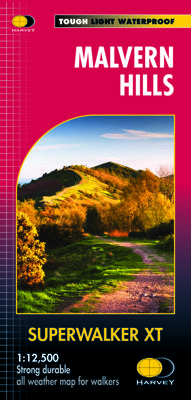
Wandelkaart Malvern Hills | Harvey Maps

0
Shows the whole of the ridge from North Malvern to Whiteleaved Oak, including the Herefordshire and Worcestershire Beacons.   Detailed map for walkers, cyclists and horseriders of the Malvern Hills Area of Outstanding Natural Beauty at 1:12,500 scale....

Verkopers met dit product

Verkoper
Bezorging
Prijs
DeZwerver.nl logo
DeZwerver.nl
2,95
16,95

Anderen bekeken ook

Wandelkaart Ochil Hills | Harvey Maps
Superwalker is designed to be the most practical tool for navigation outdoors. The format gives more mapping on the sheet without making the map heavy and bulky. The fold has been developed to allow you to open directly to any part and either side of the sheet easily - no more struggling in the wind. From Gleneagles and Auchterarder in the north and bordered by the A91 Hillfoots road in the south, this 1:25000 map for hillwalkers covers Dumyat, Ben Cleuch and Castle Craig etc. The reservoirs and hills of Glen Devon are also covered. There are enlargements of Alva, Tillicoultry, and Dollar Glens also included for easy navigation of these popular glens. The clarity of the map has also been improved to enable more people to read it without their glasses. The precise contouring and delicate hill shading give an immediate picture of the ground. Experience the satisfaction of fine navigation with the Superwalker XT25, now printed on our 100% waterproof and almost indestructible paper whatev…
24,95
Wandelkaart Pentland Hills | Harvey Maps
The whole of the Pentlands on one side of one sheet. More than a map, an essential piece of equipment this new generation HARVEY Superwalker is designed to be the most practical tool for navigation outdoors. The Superwalker XT25 is based on original HARVEY mapping with all the information a walker would expect on a map at 1:25,000 scale. Exceptionally clear. Printed on polyethylene. Strong , durable and 100% waterproof. Less than half the weight of a laminated map. GPS compatible. Places of interest also shown. The clarity of the mapping has been improved to enable more people to read it without their glasses. The map is uncluttered by information irrelevant to the walker. The precise contouring and delicate hill shading give an immediate picture of the ground. Less than half the weight of a laminated map. GPS compatible. Experience the satisfaction of fine navigation with the Superwalker XT25 now printed on our 100% waterproof and almost indestructible paper, whatever the weather!
24,95
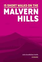
Wandelgids 15 Short Walks Malvern Hills | Cicerone
Julia Goodfellow-Smith has chosen 15 of the best short walks in the Malvern Hills for you to explore. Our guide comes with easy-to-read Ordnance Survey maps and clear route descriptions, perfect if you're new to walking or are looking for something you can enjoy with the whole family. We've included information on local beauty spots and tasty refreshment stops, and most of the walks can be completed in under 3 hours.   We haven't included any walks with challenging terrain or complicated navigation, and all you'll need to take with you are a waterproof jacket and a pair of comfortable trainers.
13,95
Wandelkaart - Fietskaart Ridgeway | Harvey Maps
Mooie, duidelijke kaart van de Ridgeway in Engeland. Geplastificeerd met veel extra informatie en uitsnedes van de route.    Leap forward in technical excellence. Tough, light and 100% wateproof   Compact and light - the map itself weighs just 60gms - a third of the weight of a laminated map, and much less bulky. And you can fold or refold it time and again, or stuff it in your back pocket and it won't fall to pieces.   Shows the entire route on one sheet.   From Overton Hill near Avebury in Wiltshire to Ivinghoe Beacon, east of Tring in Hertfordshire 137km (85 miles).   Suitable for walkers, cyclists and horseriders.   Information on finding accommodation, camping, food. Directions to the start. Also Ranger Service contact numbers and enlargements of towns/villages showing facilities available and tips on weather and clothing   Detailed mapping, full legend. National Grid - can be used with GPS. 1:40,000 scale. Waterproof. Supplied in clear plastic pocket     What the press says: '..…
25,95
Wandelkaart Brecon Beacons | Harvey Maps
"The Brecon Beacons have an irresistible draw and this is where I began my journey to the roof of the world. The breathtaking landscape provides challenges and adventures for all ages and abilities and this expertly designed map is the key to exploring it." Tori James, the first Welsh woman to climb Mount Everest Brecon Beacons - the latest edition to the popular British Mountain Map series. It covers 350 square mile of country - the only really detailed map to cover this whole area on one sheet. These maps are a leap forward in technical excellence. Tough, durable, and 100% waterproof, they are compact - not the great bulky package you get with a laminated map - and they are light to carry. This all weather British Mountain Map for climbers, hill walkers and mountaineers is published by HARVEY in co-operation with the British Mountaineering Council.
29,95

Klanten-reviews van Wandelkaart Malvern Hills | Harvey Maps

Er zijn nog geen beoordelingen voor dit productBen jij de eerste die een review plaatst?

Meer over Wandelkaart Malvern Hills | Harvey Maps

Productomschrijving

Shows the whole of the ridge from North Malvern to Whiteleaved Oak, including the Herefordshire and Worcestershire Beacons.   Detailed map for walkers, cyclists and horseriders of the Malvern Hills Area of Outstanding Natural Beauty at 1:12,500 scale.

Productinformatie

    Verken gerelateerde categorieën

    Webshop.nl maakt gebruik van cookies. Ga je verder op onze website, ga dan akkoord met het plaatsen van cookies en de verwerking van deze data door ons en vermelde partners.