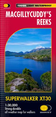
Wandelkaart Macgillycuddy's Reeks | Harvey Maps

0
Een bijzonder handige kaart van dit gebied. Op waterafstotend papier met veel details. Includes the whole of the Killarney National Park.   Detailed map for hillwalkers of MacGillycuddy’s Reeks at 1:30,000 scale.   Summit enlargement of Carrauntoohil at 1:15,000.   Shows tracks, paths and cliffs in detail.   As used by Mountain Rescue Ireland.   T...

Verkopers met dit product

Verkoper
Bezorging
Prijs
DeZwerver.nl logo
DeZwerver.nl
2,95
24,95

Anderen bekeken ook

Wandelkaart Ben Nevis | Harvey Maps
Een bijzonder mooie en handige kaart van dit prachtige bergachtige gebied. Op waterafstotend papier met veel details. HARVEY Superwalker map at 1:25,000 scale Detailed map of Ben Nevis for walkers and climbers This map for hillwalkers covers Fort William through Glen Nevis to Loch Treig. From the Grey Corries south to Kinlochleven. Ben Nevis, the Aonachs and the Mamores are among the 20 Munros and 4 Corbetts. Clear and easy to read with all the detail needed for ascending Britain's highest mountain. Enlargement of Ben Nevis summit showing the safety bearings in case of a descent in bad weather. As used by the Lochaber Mountain Rescue Team.
24,95
Wandelkaart Ben Nevis & Glen Coe | Harvey Maps
"This excellent Ben Nevis and Glen Coe map provides all the details needed for safe navigation on these iconic mountains". Cameron McNeish, outdoor writer and broadcaster.   Detailed map for hillwalkers and climbers of Ben Nevis and Glen Coe at 1:40,000 scale.   Section on navigation on Ben Nevis and detailed 1:15,000 enlargement of the summit with bad visibility descent route.   The map area includes 44 Munros, 14 Corbetts and 9 Grahams.     Serious map for serious mountains. The latest addition to the British Mountain Map series is a real heavyweight. Ben Nevis/Glencoe is the first Scottish title in this highly successful & innovative range. The map at 1:40000 has 43 Munros & 14 Corbetts on one sheet & is printed on polyethylene which is durable, tearproof & 100% waterproof. There is also colour shading for easy identification of hills and valleys & weighs less than half the weight of a laminated map. The reverse of the map has an enlargement of Ben Nevis summit, a Geological map, n…
29,95
Wandelkaart Arrochar Alps | Harvey Maps
Covers a large area yet is handily compact. Pocket perfect!   Includes Beinn Ime, Ben Vorlich and the Cobbler (Ben Arthur).   Detailed map for hillwalkers of the western part of the Loch Lomond and Trossachs National Park at the magic scale of 1:40,000.   Includes 5 Munros, 10 Corbetts and 13 Grahams.   The Arrochar Alps are a group of mountains located around the head of Loch Long, Loch Fyne, and Loch Goil, near the villages of Arrochar and Lochgoilhead, on the Cowal Peninsula in Argyll and Bute, Scotland. The mountains are especially popular with hillwalkers, due to their proximity and accessibility from Glasgow.   The Ultramap is fully detailed, genuine, original HARVEY mapping. To provide the biggest area on the smallest, lightest sheet, the Ultramap is printed double sided. The ingenious folding pattern allows you to open the Ultramap directly to any part, and either side, of the sheet. The two sides are aligned, so when you reach the edge of the Ultramap sheet you simply flip it…
20,95
Wandelkaart Assynt & Coigach | Harvey Maps
"This is a fabulous map for a fabulous area; for the first time it shows crags, bouldering areas and clear details in what could seem a maze of rock and water. It must surely set the standard for all future maps." John Mackenzie, the Earl of Cromartie.   Detailed map for hillwalkers and climbers of the spectacular peaks of Assynt at 1:40,000 scale.   Includes Quinag, Suilven, Stac Pollaidh, Cul Mor and Ben More Assynt.   Enlargements at 1:15,000 scale of Stac Pollaidh, Suilven and Quinag on the reverse.   Climbing crags are highlighted and a climbing route on Stac Pollaidh is included.   The map area includes 2 Munros, 9 Corbetts and 6 Grahams.
29,95

Klanten-reviews van Wandelkaart Macgillycuddy's Reeks | Harvey Maps

Er zijn nog geen beoordelingen voor dit productBen jij de eerste die een review plaatst?

Meer over Wandelkaart Macgillycuddy's Reeks | Harvey Maps

Productomschrijving

Een bijzonder handige kaart van dit gebied. Op waterafstotend papier met veel details.

Includes the whole of the Killarney National Park.   Detailed map for hillwalkers of MacGillycuddy’s Reeks at 1:30,000 scale.   Summit enlargement of Carrauntoohil at 1:15,000.   Shows tracks, paths and cliffs in detail.   As used by Mountain Rescue Ireland.   Tough, light, durable and 100% waterproof Genuine, original, HARVEY mapping Easy to re-fold

Productinformatie

    Verken gerelateerde categorieën

    Webshop.nl maakt gebruik van cookies. Ga je verder op onze website, ga dan akkoord met het plaatsen van cookies en de verwerking van deze data door ons en vermelde partners.