Wandelkaart Lake District Noord | Harvey Maps

0
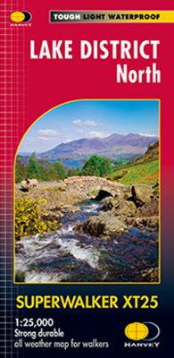
New Superwalker XT25 of the Lake District. Revised and re-designed It's got everything! Genuine original HARVEY mapping at 1:25,000. Clear, easy to read. Easy to re-fold. Opens directly to either side of the sheet. Slim and flexible. Light to carry. Tearproof, durable, AND 100% waterproof as standard - no need for a map case. The Lake District Nat...

Verkopers met dit product

Verkoper
Bezorging
Prijs
DeZwerver.nl logo
DeZwerver.nl
2,95
24,95

Anderen bekeken ook

Nieuw
Wandelkaart Peak District Noord | Harvey Maps
New, Superwalker XT25 of the Peak District. Revised and re-designed It's got everything! Genuine original HARVEY mapping at 1:25,000. Ideal for walking. Clear, easy to read. Easy to re-fold. Opens directly to either side of the sheet. Slim and flexible. Light to carry. Tearproof and durable. AND, 100% waterproof as standard. The Peak District National Park on 3 sheets. PEAK DISTRICT NORTH covers The Dark Peak, including Snake Pass, Bleaklow and Derwent Reservoir and extends north to Saddleworth Moor, Wessenden Moor and Marsden.
24,95
Nieuw
Wandelkaart Peak District Central | Harvey Maps
New Superwalker XT25 of the Peak District Revised and re-designed. It's got everything! Genuine original HARVEY mapping at 1:25,000. Ideal for walking. Clear, easy to read. Easy to re-fold. Opens directly to either side of the sheet. Slim and flexible. Light to carry. Tearproof and durable. AND 100% waterproof as standard The Peak District National Park on 3 sheets Peak District Central includes the heart of the Peak District between Sheffield and Manchester. Includes Edale, Kinder Scout, the Gritstone Edges and Ladybower Reservoir
24,95
Nieuw
Wandelkaart Lake District Noord | Harvey Maps
HARVEY launch innovative new series: Ultramap XT40. 16 titles featuring in Trail magazine through spring 2016. 40 years experience have gone into HARVEY's most creative new series. The Ultramap covers a large area yet is small enough to slip in a pocket. The Ultramap is fully detailed genuine original HARVEY mapping. The Ultramap is tough and 100% waterproof. Use it without a map case, whatever the weather! To provide the biggest area on the smallest lightest sheet, the Ultramap is printed double sided. The ingenious folding pattern allows you to open the Ultramap directly to any part and either side of the sheet. The two sides are aligned, so when you reach the edge of the Ultramap sheet you simply flip it over without re-folding. There's an overlap as well so you can map read continuously. The magic scale of 1:40,000 enables the Ultramap to provide all the detail you would expect to find on a large scale walking map including rights of way and boundaries. Actual size 73mm x 152mm. P…
19,50
Nieuw
Wandelkaart Brecon Beacons Oost | Harvey Maps
Includes Pen y Fan and the Black Mountains.   Detailed map for hillwalkers of the western part of the Brecon Beacons National Park at the popular scale of 1:25,000.   NEW Superwalker XT25 of the Brecon Beacons. The Brecon Beacons National Park on 2 sheets. Revised and re-designed. Brecon Beacons EAST - The area covered on this sheet includes Pen y Fan and the Black Mountains. They have got everything. Genuine original HARVEY mapping at 1:25,000. Ideal for walking. Clear, easy to read. Easy to re-fold. Opens directly to either side of the sheet. Slim and flexible, light to carry, tearproof, durable AND, 100% waterproof as standard.    
24,95
Wandelkaart Lake District | Harvey Maps
"The best Lake District map I have ever seen. The 1:40,000 scale provides clear, detailed information to one of the most popular hill walking areas in Britain." Sir Chris Bonington, mountaineer. A new generation of tough polyethylene maps. These maps are a leap forward in technical excellence. Tough, durable and 100% waterproof they are compact - not the great bulky package you get with a laminated map - and light to carry. This all weather British Mountain Map for climbers, hill wallkers, mountaineers and mountain bikers is published by HARVEY in co-operation with the British Mountaineering Council. The Lake District's famous mountains and fells on a single map, colour shading for easy identification of hills and valleys and detailed crag information for climbers. The reverse side of the map includes detailed 1:20000 enlargements of Scafell, Gable, Bowfell, Langdale Pikes and Pillar, a Geological map of the Lake District, mountain incident and first aid advice.
31,95
Nieuw
Wandelgids Lake District High Level and Fell Walks | Cicerone
A guidebook to 30 high level day walks in the Lake District, exploring some of the best mountains, ridgewalks, fells and summits within the national park. Mostly circular except for a few linear routes that make use of public transport links, the walks are graded according to difficulty, ensuring there is something for all levels of fitness and experience. The walks range from 7 to 24km (4–15 miles) in length and can be completed in between 3 and 9 hours.   They are arranged geographically into 6 areas: Keswick, Borrowdale and Buttermere, the Western Valleys, Coniston and Langdale, Ambleside and Windermere, and Ullswater. 1:50,000 OS maps for each walkGPX files available to downloadDetailed information on terrain, refreshments and public transport for each walkInformation given on local history and archaeologyHighlights include Scafell Pike, Scafell, Helvellyn, Skiddaw, Newlands Round and the Fairfield Horseshoe   Pocket-sized guide to 30 of the best walks on the higher Lake District…
18,50
Nieuw
Wandelgids Walking the Lake District Fells - Keswick and the North | Cicerone
Uitstekende wandelgids voor dit uitdagende wandelgebied. This guide describes ascents of 30 Lake District fells that can be climbed from Keswick, the Whinlatter Pass, Bassenthwaite, Hesket Newmarket, Mungrisdale and Threlkeld. The giants of the region Skiddaw and Blencathra need little introduction, their myriad routes attracting many a visitor and promising fantastic far-reaching views. The summits to the north, however, are less frequented, offering probably the closest experience to wilderness walking the Lakes has to offer, whereas to the west, the Whinlatter group present a sylvan alternative.Unlike other guidebooks which describe a single or limited number of routes to a particular destination, the aim of the Walking the Lake District Fells series is to offer all the options. These are presented as numbered sections which can be combined to create infinite possibilities - from simple ascents to longer ridge routes. You'll find the classics and popular routes alongside less tradi…
20,95
Reisgids Pocket Lake District | Lonely Planet
Pocket reisgidsen van Lonely Planet zijn een kleinere versie dan de 'echte' Planets. Vaak echter van bijzondere bestemmingen binnen een bepaald land waardoor er meer aandacht is en uitgebreidere tips zijn voor die bepaalde streek i.v.m. de grote Planets. Handzaam formaat, makkelijk in de binnenzak! Toch ook deze vol met praktische informatie. Lonely Planet's Pocket Lake District is your passport to the most relevant, up-to-date advice on what to see and skip, and what hidden discoveries await you. Climb to the top of Scafell Pike for eye-popping views, spot the inspiration for Beatrix Potter's tales at Hill Top and cruise Coniston Water in stately 19th-century style on a steam yacht gondola - all with your trusted travel companion. Get to the heart of the Lake District and begin your journey now! Inside Lonely Planet's Pocket Lake District: Full-colour maps and images throughout Highlights and itineraries help you tailor your trip to your personal needs and interests Insider tips …
12,95
Wandelgids Day Walks in the Lake District | Vertebrate Publishing
Day Walks in the Lake District features 20 circular routes between 5 and 13 miles (8 and 21 kilometres) in length, suitable for hillwalkers of all abilities. The routes are split into four geographical areas - north, east, south and west - and include walks from the main tourist bases, such as Keswick and Ambleside, as well as sought after peaks, such as Scafell Pike, Great Gable, Blencathra and Helvellyn. Also included for the adventurous are the Lake District's best known scrambles - Striding Edge on Helvellyn and Sharp Edge on Blencathra - together with more accessible alternatives.   The author of this guidebook, Stephen Goodwin, is a former freelance journalist (former staff writer for The Independent), and a Lake District local. In his introductions to each route he recalls the tales of Wordsworth, Walpole and the fascinating history of Lakeland and its peaks and fells. Each route in this guide is described with easy-to-follow directions and details of distance, navigation infor…
20,95

Klanten-reviews van Wandelkaart Lake District Noord | Harvey Maps

Er zijn nog geen beoordelingen voor dit productBen jij de eerste die een review plaatst?

Meer over Wandelkaart Lake District Noord | Harvey Maps

Productomschrijving

New Superwalker XT25 of the Lake District. Revised and re-designed It's got everything! Genuine original HARVEY mapping at 1:25,000. Clear, easy to read. Easy to re-fold. Opens directly to either side of the sheet. Slim and flexible. Light to carry. Tearproof, durable, AND 100% waterproof as standard - no need for a map case. The Lake District National Park on just 4 sheets. This Lake District North covers the northern fells including Skiddaw, Blencathra, Great Calva Keswick and Derwentwater

Verken gerelateerde categorieën

Webshop.nl maakt gebruik van cookies. Ga je verder op onze website, ga dan akkoord met het plaatsen van cookies en de verwerking van deze data door ons en vermelde partners.