webshop.nl

Wandelkaart - Fietskaart Ridgeway | Harvey Maps

0
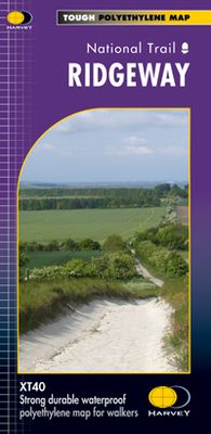
Mooie, duidelijke kaart van de Ridgeway in Engeland. Geplastificeerd met veel extra informatie en uitsnedes van de route.    Leap forward in technical excellence. Tough, light and 100% wateproof   Compact and light - the map itself weighs just 60gms - a third of the weight of a laminated map, and much less bulky. And you can fold or refold it time...

Webshops met dit product

Webshop
Bezorging
Prijs
DeZwerver.nl logo
DeZwerver.nl
niet bekend
25,95

Anderen bekeken ook

Wandelkaart North Downs Way | Harvey Maps
Mooie, duidelijke kaart van de North Downs Way in Engeland. Geplastificeerd met veel extra informatie en uitsnedes van de route.    XT40 - Leap forward in technical excellence. Tough, light and 100% waterproof   Compact and light - the map itself weighs just 60gms - a third of the weight of a laminated map, and much less bulky. And you can fold or refold it time and again, or stuff it in your back pocket and it won't fall to pieces.   Revised edition and format Shows the entire route on one XT40 map sheet.   The Way is 246km (156 miles). This map covers the whole route from Farnham in the west to Dover on the south east coast.   Information on finding accommodation, camping, food. Directions to the start and end points. Shows facilities available and includes tips on weather and clothing.     Detailed mapping, full legend. National Grid - can be used with GPS. 1:40,000 scale. Waterproof. Supplied in clear plastic pocket.
25,50
Wandelkaart Cape Wrath Trail North | Harvey Maps
Een bijzonder handige kaart van dit lange-afstands-wandelpad. Op waterafstotend papier met veel details. Het enige dat je eigenlijk een beetje mist is een overzicht. Verder uitstekend en voldoende voor de route.   XT40 - Leap forward in technical excellence. Tough, light and 100% waterproof   Compact and light - the map itself weighs just 60gms - a third of the weight of a laminated map, and much less bulky. And you can fold or refold it time and again, or stuff it in your back pocket and it won't fall to pieces. Shows the entire route on one sheet.   The Cape Wrath Trail is a challenging route from Fort William to Cape Wrath. It is around 200 miles long and passes through some of Scotland's wildest and most spectacular scenery.   This map covers the northern section of the route, from Strathcarron to Cape Wrath.   The trail has evolved from use and is not an officially recognised National Trail. There is no single definitive route. There are various ways of tackling the traverse all …
28,50
Wandelkaart Coast to Coast | Harvey Maps
Een bijzonder handige kaart van dit lange-afstands-wandelpad. Op waterafstotend papier met veel details. Het enige dat je eigenlijk een beetje mist is een overzicht. Verder uitstekend en voldoende voor de route. Leap forward in technical excellence. Tough, light and 100% wateproof Compact and light - the map itself weighs just 60gms - a third of the weight of a laminated map, and much less bulky. And you can fold or refold it time and again, or stuff it in your back pocket and it won't fall to pieces.Shows the 96 mile western half of the route on one sheet. Covers the section from St Bees to Keld. Includes alternative routes. This map is bio-degradable Information on finding accommodation, camping, food. Directions to the start. Also Ranger Service contact numbers and enlargements of towns/villages showing facilities available and tips on weather and clothing Detailed mapping, full legend. National Grid - can be used with GPS. 1:40,000 scale. Waterproof. Supplied in clear plastic pock…
28,50
Wandelkaart Settle to Carlisle Way | Harvey Maps
Mooie, duidelijke kaart van de Settle to Carlisle Way in Noord-Engeland. Geplastificeerd met veel extra informatie en uitsnedes van de route. Settle Carlisle Way is a walking route linking the stations of the famous and scenic Settle-Carlisle Railway Line. This map gives you the chance to walk up and ride back on the train, or to hop off at one station and rejoin a later train further on. The route starts in picturesque Settle and passes through the beautiful Yorkshire Dales and the sheltered Eden Valley, ending in central Carlisle. The entire route is on the one map. Tough and 100% waterproof Compact and light - the map itself weighs just 60gms - a third of the weight of a laminated map, and much less bulky. And you can fold or refold it time and again, or stuff it in your pocket and it won't fall to pieces. Shows the entire route on one sheet. Information on finding accommodation, camping, food. Directions to the start. Also Ranger Service contact numbers and enlargements of towns/v…
21,50
Wandelkaart Glyndwr's Way | Harvey Maps
XT40. Leap forward in technical excellence. Tough, light and 100% waterproof   Compact and light - the map itself weighs just 60gms - a third of the weight of a laminated map, and much less bulky. And you can fold or refold it time and again, or stuff it in your back pocket and it won't fall to pieces. Shows the entire route on one sheet.   Glyndwr's Way is a 217km (135 mile) long National Trail meandering through the open moorland, rolling farmland, woodland and forest of mid-Wales. The Way starts at Knighton and ends in Welshpool. It takes you to some of the finest landscape features in Wales including the tranquil Radnorshire Hills, the shores of the Clywedog Reservoir and heather clad Plynlimon. There are also spectacular views over Cadair Idris, Lake Vyrnwy, the Cambrian mountains and Y Golfa. The highest point on the route is Foel Fadian at 510m (1530ft).    The map is arranged in panels so that at any one time you only have to have the part you need open. It is supplied folded…
25,95
Wandelkaart Hadrian's Wall | Harvey Maps
Een bijzonder handige kaart van dit lange-afstands-wandelpad. Op waterafstotend papier met veel details. Het enige dat je eigenlijk een beetje mist is een overzicht. Verder uitstekend en voldoende voor de route. Compact and light - the map itself weighs just 60gms - a third of the weight of a laminated map, and much less bulky. And you can fold or refold it time and again, or stuff it in your back pocket and it won't fall to pieces. Entire route on one map. 130km (81 miles) from the Solway Coast to Newcastle. Opportunity to visit a large number of historical sites along the way. Information on finding accommodation, camping, food. Directions to the start. Also Ranger Service contact numbers and enlargements of towns/villages showing facilities available and tips on weather and clothing Detailed mapping, full legend. National Grid - can be used with GPS. 1:40,000 scale. Waterproof. Supplied in clear plastic pocket
25,95
Wandelkaart Cape Wrath Trail South | Harvey Maps
Een bijzonder handige kaart van dit lange-afstands-wandelpad. Op waterafstotend papier met veel details. Het enige dat je eigenlijk een beetje mist is een overzicht. Verder uitstekend en voldoende voor de route. XT40 - Leap forward in technical excellence. Tough, light and 100% waterproof   Compact and light - the map itself weighs just 60gms - a third of the weight of a laminated map, and much less bulky. And you can fold or refold it time and again, or stuff it in your back pocket and it won't fall to pieces. Shows the entire route on one sheet.   The Cape Wrath Trail is a challenging route from Fort William to Cape Wrath. It is around 200 miles long and passes through some of Scotland's wildest and most spectacular scenery.   This map covers the southern section of the route, from Fort William to Strathcarron.   The trail has evolved from use and is not an officially recognised National Trail. There is no single definitive route. There are various ways of tackling the traverse all …
28,50
Wandelkaart Cleveland Way | Harvey Maps
Mooie, duidelijke kaart van de Cleveland Way in Noord-Engeland. Geplastificeerd met veel extra informatie en uitsnedes van de route.    Leap forward in technical excellence. Tough, light and 100% waterproof Compact and light - the map itself weighs just 60gms - a third of the weight of a laminated map, and much less bulky. And you can fold or refold it time and again, or stuff it in your back pocket and it won't fall to pieces. Shows the entire route on one sheet.   174km (109 miles) from Helmsley across the North York Moors National Park to Saltburn and along the coast via Scarborough ending at Filey.   Information on finding accommodation, camping, food. Directions to the start. Also Ranger Service contact numbers and enlargements of towns/villages showing facilities available and tips on weather and clothing.   Detailed mapping, full legend. National Grid - can be used with GPS. 1:40,000 scale. Waterproof. Supplied in clear plastic pocket
25,95
Wandelkaart Rob Roy Way | Harvey Maps
Mooie, duidelijke kaart van de Rob Roy Way in Schotland. Geplastificeerd met veel extra informatie en uitsnedes van de route.    One of Scotland's Great Trails   Rob Roy Way is a walk across part of the Southern Highlands of Scotland taking in some of the most beautiful countryside in the UK. Starting from Drymen it goes north east to finish in Pitlochry. The Way is 77mls or 94 mls (124Km or 151Km) depending on your route choice. The tracks and paths you follow were used by Rob RoyMacGregor in the 17th & 18th centuries, other historical characters throughout the Jacobite uprisings and during the feuds between the local clans. Places you will pass through include Aberfoyle, Callander, Strathyre, Killin or Amulree and Aberfeldy. Lochs you will walk along include Venachar, Lubnaig and Tay passing by Ben Ledi, Ben Chonzie and Ben Lawers.   XT40 New generation of tough polyethylene maps   The HARVEY series of Long Distance Route maps is an established success. Now the advanced technology u…
25,95
Wandelkaart Speyside Walk (Schotland) | Harvey Maps
Een bijzonder handige kaart van dit lange-afstands-wandelpad van 144 km. Op waterafstotend papier met veel details, uitstekend en voldoende voor deze route. A leap forward in technical excellence: Tough, durable and 100% waterproof - virtually indestructible in normal use. Compact and light - the map itself weighs just 60gms - a third of the weight of a bulky laminated map. You can fold or refold it time and again, or stuff it in your back pocket and it won't fall to pieces. Shows the entire route on one sheet. 144km (90 miles) from Aviemore to Buckie, via Nethybridge, Grantown and Fochabers, with a spur to Tomintoul. 
25,95

Klanten-reviews van Wandelkaart - Fietskaart Ridgeway | Harvey Maps

Er zijn nog geen beoordelingen voor dit productBen jij de eerste die een review plaatst?

Meer over Wandelkaart - Fietskaart Ridgeway | Harvey Maps

Productomschrijving

Mooie, duidelijke kaart van de Ridgeway in Engeland. Geplastificeerd met veel extra informatie en uitsnedes van de route.    Leap forward in technical excellence. Tough, light and 100% wateproof   Compact and light - the map itself weighs just 60gms - a third of the weight of a laminated map, and much less bulky. And you can fold or refold it time and again, or stuff it in your back pocket and it won't fall to pieces.   Shows the entire route on one sheet.   From Overton Hill near Avebury in Wiltshire to Ivinghoe Beacon, east of Tring in Hertfordshire 137km (85 miles).   Suitable for walkers, cyclists and horseriders.   Information on finding accommodation, camping, food. Directions to the start. Also Ranger Service contact numbers and enlargements of towns/villages showing facilities available and tips on weather and clothing   Detailed mapping, full legend. National Grid - can be used with GPS. 1:40,000 scale. Waterproof. Supplied in clear plastic pocket  


What the press says: '...try Harvey's Ridgeway map which does the whole thing in a single go.' Country Walking magazine Feb 2009

Verken gerelateerde categorieën

Webshop.nl maakt gebruik van cookies. Ga je verder op onze website, ga dan akkoord met het plaatsen van cookies en de verwerking van deze data door ons en vermelde partners.