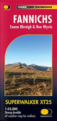
Wandelkaart Fannichs Seana Bhraigh & Ben Wyvis | Harvey Maps

0
Detailed map for hillwalkers of the Fannichs ridge at the popular 1:25,000 scale. This is an area located to the south of Ullapool and to the west of Dingwall. Includes the munros Sgurr Mor, Beinn Dearg and Seana Bhraigh. Includes an inset of the Munro, Ben Wyvis. Shows 17 Munros, 3 Corbetts and 3 Grahams....

Verkopers met dit product

Verkoper
Bezorging
Prijs
DeZwerver.nl logo
DeZwerver.nl
2,95
24,95

Anderen bekeken ook

Wandelgids The Munros | Pocket Mountains
The Munros are mountains in Scotland with a height of over 3000ft and take their name from the first list of such hills published in 1891 by Victorian mountaineer Sir Hugh Munro, 4th Baronet of Lindertis. Revised several times in the years since, the official list now features 282 peaks. This guide is for anyone who wants to climb these mountains and aims to provide reliable routes and tips for ascending them safely.   The Munros will ensure you reach parts of Scotland you might otherwise overlook, spend memorable evenings in pubs, bothies and wild camps, and have encounters with other walkers, locals and wildlife that enhance the adventure regardless of whether you get to the top of one Munro or all of them. Plaatsen in het boekje A’ Bhuidheanach Bheag, A’ Chailleach (Fannichs), A’ Chailleach (Monadhliath), A’ Chralaig, Ghlas-bheinn, A’ Mhaighdean, A’ Mharconaich, Am Basteir, Am Bodach, Am Faochagach, An Caisteal, An Coileachan, An Gearanach, An Riabhachan, An Sgarsoch, An Socach (De…
20,95
Wandelgids 1 Walking The Munros Vol 1 Southern, Central and Western Highlands - Schotland | Cicerone
Uitstekende wandelgids van het zuiden, midden en westen van de Schotse Hooglanden. Goed beschreven met veel praktische informatie om de route te kunnen lopen, inclusief redelijke kaarten. Guidebook to walking the Munros in southern, central and western Highlands. Describes 69 challenging routes across 139 of the iconic 3000ft+ mountains covering areas such as Glencoe, Bridge of Orchy and Mull. Includes routes up Ben More, Ben Alder, Ben Lomond and Ben Nevis, the highest mountain in the British Isles. Volume 1 of two guidebooks.   Seasons The guide is intended for summer hillwalkers (usually April/May to October in Scotland). In winter conditions the routes become more serious mountaineering expeditions requiring appropriate skills, equipment and experience.   Centres Arrochar, Crianlarich, Killin, Pitlochry, Tyndrum, Glencoe, Fort William, Spean Bridge, Dalwhinnie, Braemar, Glenshee   Difficulty Most of the Munros are straightforward walks but some involve ridge walking, sc…
20,95
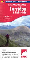
Wandelkaart Torridon & Fisherfield | Harvey Maps
"HARVEY British Mountain Maps are a joy to use. The detail and accuracy make them my first choice when I am researching a route or just out on the hills for fun". Peter Macfarlane, outdoor writer and photographer.   Detailed map of the giants of Torridon and the remote hills of Fisherfield on one sheet at 1:40,000 scale.   Summit enlargements of Beinn Alligin, Beinn Eighe, Liathach and An Teallach.   Includes 18 Munros, 12 Corbetts and 9 Grahams.     The giants of Torridon and the remote hills of Fisherfields on one sheet. The map area includes 18 Munros and 12 Corbetts. There are also 1:15000 enlargements of An Teallach, Beinn Alligin, Beinn Eighe and Liathach on the reverse. Climbing crags are highlighted and climbing crag route diagrams are also included. Harvey British Mountain maps are a joy to use. The detail and accuracy make them my first choice when I am researching a route or out on the hills.
29,95
Wandelkaart Skye The Cuillin | Harvey Maps
New Revised Edition and Format. More than a map, an essential piece of equipment this new generation HARVEY Superwalker is designed to be the most practical tool for navigation outdoors. The format gives more mapping on the sheet without making the map heavy and bulky. The fold has been developed to allow you to open directly to any part and either side of the sheet easily. No more struggling in the wind. The Superwalker XT25 is based on original HARVEY mapping with all the information a walker would expect on a map at 1:25,000 scale. Walls and fences on farmland are now shown. The clarity of the mapping has been improved to enable more people to read it without their glasses. The map is uncluttered by information irrelevant to the walker. The precise contouring and delicate hill shading give an immediate picture of the ground. Experience the satisfaction of fine navigation with the Superwalker XT25, now printed on our 100% waterproof and almost indestructible paper, whatever the weat…
24,95
Wandelkaart Arrochar Alps | Harvey Maps
Covers a large area yet is handily compact. Pocket perfect!   Includes Beinn Ime, Ben Vorlich and the Cobbler (Ben Arthur).   Detailed map for hillwalkers of the western part of the Loch Lomond and Trossachs National Park at the magic scale of 1:40,000.   Includes 5 Munros, 10 Corbetts and 13 Grahams.   The Arrochar Alps are a group of mountains located around the head of Loch Long, Loch Fyne, and Loch Goil, near the villages of Arrochar and Lochgoilhead, on the Cowal Peninsula in Argyll and Bute, Scotland. The mountains are especially popular with hillwalkers, due to their proximity and accessibility from Glasgow.   The Ultramap is fully detailed, genuine, original HARVEY mapping. To provide the biggest area on the smallest, lightest sheet, the Ultramap is printed double sided. The ingenious folding pattern allows you to open the Ultramap directly to any part, and either side, of the sheet. The two sides are aligned, so when you reach the edge of the Ultramap sheet you simply flip it…
19,50
Wandelkaart Munro and Corbett Chart | Harvey Maps
Alle Munro's en Corbetts op 1 kaart!  First published in 1996 this current edition of our best selling chart used for monitoring and recording your progress in completing the Munros and Corbetts has been brought up to date to include the height revisions of 2009 and 2011 according to the Munro Society. It also includes the Grahams and the Donalds. It can be removed from the cover without damage and wall mounted. Based on the 1997 edition of Munro's Tables progress can be monitored filling in the targets or the symbols on the map and by recording the date of each ascent. The symbols have been updated to make them easier to read, and can now be identified clearly by the colour blind. This Munro map is a chart which shows and lists all Munros (mountains over 3000ft), Corbetts (over 2500ft), Grahams and Donalds (over 2000ft). A selection of other hills are named for information.   Size 880x1145mm.   Space for recording your date of ascent.   Target to fill in as you complete the challenge…
17,95
Wandelkaart Suilven / Stac Pollaidh / Lochinver | Harvey Maps
Detailed map for runners and walkers of Suilven and the surrounding area at the magic scale of 1:40,000. Covers a large area yet is handily compact. Pocket perfect! This is a fantastic and beautiful area, with Suilven at its centre. The map includes the two Munros of Ben More Assynt and Conival, as well as other famous mountains such as Cul Mor, Cul Beag, Canisp and Stac Pollaidh. Coverage is extended to the north with an inset of Quinag. The map shows 2 Munros, 8 Corbetts and 3 Grahams. Fully detailed genuine HARVEY mapping Use without a map case: tough and 100% waterproof Opens directly to either side of the sheet
19,50
Wandelkaart Ben Alder | Harvey Maps
Superwalker is designed to be the most practical tool for navigation outdoors. The Superwalker XT25 is based on original HARVEY mapping with all the information a walker would expect on a map at 1:25,000 scale. Includes 23 Munros, 4 Corbetts and 3 Grahams all on one sheet. Also includes Creag Meagaidh National Nature Reserve. The format gives more mapping on the sheet without making the map heavy and bulky. The fold has been developed to allow you to open directly to any part, and either side of the sheet easily no more struggling in the wind. The clarity of the mapping has been improved to enable more people to read it without their glasses. The map is uncluttered by information irrelevant to the walker. The precise contouring and delicate hill shading give an immediate picture of the ground. Less than half the weight of a laminated map. GPS compatible. Experience the satisfaction of fine navigation with the Superwalker XT25 now printed on our 100% waterproof and almost indestructibl…
24,95
Wandelkaart Assynt & Coigach | Harvey Maps
"This is a fabulous map for a fabulous area; for the first time it shows crags, bouldering areas and clear details in what could seem a maze of rock and water. It must surely set the standard for all future maps." John Mackenzie, the Earl of Cromartie.   Detailed map for hillwalkers and climbers of the spectacular peaks of Assynt at 1:40,000 scale.   Includes Quinag, Suilven, Stac Pollaidh, Cul Mor and Ben More Assynt.   Enlargements at 1:15,000 scale of Stac Pollaidh, Suilven and Quinag on the reverse.   Climbing crags are highlighted and a climbing route on Stac Pollaidh is included.   The map area includes 2 Munros, 9 Corbetts and 6 Grahams.
29,95

Klanten-reviews van Wandelkaart Fannichs Seana Bhraigh & Ben Wyvis | Harvey Maps

Er zijn nog geen beoordelingen voor dit productBen jij de eerste die een review plaatst?

Meer over Wandelkaart Fannichs Seana Bhraigh & Ben Wyvis | Harvey Maps

Productomschrijving

Detailed map for hillwalkers of the Fannichs ridge at the popular 1:25,000 scale. This is an area located to the south of Ullapool and to the west of Dingwall. Includes the munros Sgurr Mor, Beinn Dearg and Seana Bhraigh. Includes an inset of the Munro, Ben Wyvis. Shows 17 Munros, 3 Corbetts and 3 Grahams.

Productinformatie

    Verken gerelateerde categorieën

    Webshop.nl maakt gebruik van cookies. Ga je verder op onze website, ga dan akkoord met het plaatsen van cookies en de verwerking van deze data door ons en vermelde partners.