webshop.nl
Categorieën
  Sluiten

Meer Harvey Maps
Meer Harvey Maps in Gezondheid & psychologie boeken

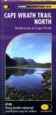
Wandelkaart Cape Wrath Trail North | Harvey Maps

0
Een bijzonder handige kaart van dit lange-afstands-wandelpad. Op waterafstotend papier met veel details. Het enige dat je eigenlijk een beetje mist is een overzicht. Verder uitstekend en voldoende voor de route.   XT40 - Leap forward in technical excellence. Tough, light and 100% waterproof   Compact and light - the map itself weighs just 60gms - a...

Webshops met dit product

Webshop
Bezorging
Prijs

Anderen bekeken ook

Wandelkaart Cape Wrath Trail South | Harvey Maps
Een bijzonder handige kaart van dit lange-afstands-wandelpad. Op waterafstotend papier met veel details. Het enige dat je eigenlijk een beetje mist is een overzicht. Verder uitstekend en voldoende voor de route. XT40 - Leap forward in technical excellence. Tough, light and 100% waterproof   Compact and light - the map itself weighs just 60gms - a third of the weight of a laminated map, and much less bulky. And you can fold or refold it time and again, or stuff it in your back pocket and it won't fall to pieces. Shows the entire route on one sheet.   The Cape Wrath Trail is a challenging route from Fort William to Cape Wrath. It is around 200 miles long and passes through some of Scotland's wildest and most spectacular scenery.   This map covers the southern section of the route, from Fort William to Strathcarron.   The trail has evolved from use and is not an officially recognised National Trail. There is no single definitive route. There are various ways of tackling the traverse all o…
28,50
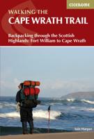
Wandelgids The Cape Wrath Trail | Cicerone
Uitstekende wandelgids die in etappes de route nauwkeurig beschijft.  A guidebook to the Cape Wrath Trail, a long-distance trek through the Scottish Highlands from Fort William to Cape Wrath. The Cape Wrath Trail is a 230-mile, three-week challenge through wild and magnificent landscapes, such as Morar, Knoydart, Torridon and Assynt. Crossing such empty country, it is for the experienced backpacker only. Activities Long-distance walking and backpacking   Seasons April, May and June are ideal months to walk the trail. September and October are also good, but there may be diversions due to deer stalking and military operations at the cape. In July and August the days are superbly long and the weather can be fine, but midges will be in full flight. The limited accommodation along the trail may also be booked up at this time of year   Centres Fort William, Glenfinnan, Barisdale, Kinloch Hourn, Shiel Bridge, Strathcarron, Kinlochewe, Dundonnell, Ullapool, Bridge of Orchy, Inchnadamph, Kyles…
23,95
Wandelkaart Pennine Way North | Harvey Maps
Mooie, duidelijke kaart van het Noordelijke gedeelte van de Pennine Way (Middleton-in-Teesdale naar Kirk Yetholm). The whole of the Pennine Way on just 2 maps!   Pennine Way North map covers the route from Middleton-in-Teesdale to Kirk Yetholm.   The Pennine Way is a National Trail. It follows the backbone of England from the Peak District to the Scottish borders. It is one of the toughest UK long distance footpaths, and forms part of the European Footpath Network.   The Pennine Way was Britain's first National Trail, opened in 1965.   Just 2 HARVEY maps cover the whole 431km (268 miles) route. Each starts and finishes near public transport, so no hassle with getting lifts.   Each map also contains lots of information and useful telephone numbers to assist the walker with planning.   Tough, light, durable and 100% waterproof Includes Rights of Way Genuine original HARVEY mapping Route clearly marked
28,50
Wandelkaart North Downs Way | Harvey Maps
Mooie, duidelijke kaart van de North Downs Way in Engeland. Geplastificeerd met veel extra informatie en uitsnedes van de route.    XT40 - Leap forward in technical excellence. Tough, light and 100% waterproof   Compact and light - the map itself weighs just 60gms - a third of the weight of a laminated map, and much less bulky. And you can fold or refold it time and again, or stuff it in your back pocket and it won't fall to pieces.   Revised edition and format Shows the entire route on one XT40 map sheet.   The Way is 246km (156 miles). This map covers the whole route from Farnham in the west to Dover on the south east coast.   Information on finding accommodation, camping, food. Directions to the start and end points. Shows facilities available and includes tips on weather and clothing.     Detailed mapping, full legend. National Grid - can be used with GPS. 1:40,000 scale. Waterproof. Supplied in clear plastic pocket.
25,50
Wandelkaart Pennine Bridleway | Harvey Maps
Mooie, duidelijke kaart van de Pennine Bridle Way in Noord-Engeland. Geplastificeerd met veel extra informatie en uitsnedes van de route.    Pennine Bridleway South map - Derbyshire to South Pennines   Entire route on one map - 330km (205 miles)   The Pennine Bridleway is the only National Trail purpose built for horse riders, mountain bikers and walkers. This map covers the entire route from Derbyshire to Cumbria - Middleton Top to Ravenstonedale.   The Trail for mountain bikers starts at Middleton Top near Matlock whereas horse riders can join at Hartington Station. The Trail intersects the limestone plateau of the White Peak, winding through scenic dales before climbing to the more challenging terrain of the Dark Peak. Moving north, from the top of the Mary Towneley Loop, the Trail heads across the hills into the Ribble Valley before reaching the stunning limestone landscape of the Yorkshire Dales and the Settle Loop.   The route continues through the Mallerstang valley befor…
28,50
Wandelkaart Skye Trail | Harvey Maps
Een bijzonder handige kaart van dit lange-afstands-wandelpad. Op waterafstotend papier met veel details. Het enige dat je eigenlijk een beetje mist is een overzicht. Verder uitstekend en voldoende voor de route.   The Skye Trail is a challenging unmarked route of 127km (79 miles) through the island of Skye. It is specifically aimed at experienced hillwalkers. The Skye Trail is a challenging unofficial route through the island. The route follows much of the amazing Trotternish Ridge and passes beneath the peaks and pinnacles of the Cuillin, which are considered to be the finest mountains in Britain. There are also remarkable coastal cliffs, steep trails, high drops and haunting ruins of deserted villages destroyed in the highland clearances. You have various choices of different routes through tough terrain or easier walking with spectacular mountain views and coastal scenery. It is not waymarked making this map an essential piece of your equipment.
25,95

Klanten-reviews van Wandelkaart Cape Wrath Trail North | Harvey Maps

Er zijn nog geen beoordelingen voor dit productBen jij de eerste die een review plaatst?

Meer over Wandelkaart Cape Wrath Trail North | Harvey Maps

Productomschrijving

Een bijzonder handige kaart van dit lange-afstands-wandelpad. Op waterafstotend papier met veel details. Het enige dat je eigenlijk een beetje mist is een overzicht. Verder uitstekend en voldoende voor de route.   XT40 - Leap forward in technical excellence. Tough, light and 100% waterproof   Compact and light - the map itself weighs just 60gms - a third of the weight of a laminated map, and much less bulky. And you can fold or refold it time and again, or stuff it in your back pocket and it won't fall to pieces. Shows the entire route on one sheet.   The Cape Wrath Trail is a challenging route from Fort William to Cape Wrath. It is around 200 miles long and passes through some of Scotland's wildest and most spectacular scenery.   This map covers the northern section of the route, from Strathcarron to Cape Wrath.   The trail has evolved from use and is not an officially recognised National Trail. There is no single definitive route. There are various ways of tackling the traverse all of which are highlighted on the maps leaving the actual route choice to the individual walker. This is rough country not to be underestimated. Some sections of the route will require an overnight stop in the mountains. This will either have to be wild camping or the use of a bothy. The bothies are also shown on the map.

Productspecificaties

Artikelnummer(s)
Brand
Harvey Maps

Verken gerelateerde categorieën

Webshop.nl maakt gebruik van cookies. Ga je verder op onze website, ga dan akkoord met het plaatsen van cookies en de verwerking van deze data door ons en vermelde partners.