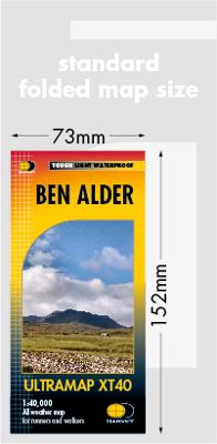
Wandelkaart Ben Alder | Harvey Maps

0
Covers a large area yet is handily compact. Pocket perfect!Detailed map for runners and walkers of the hills between Loch Tay and Loch Rannoch at the magic scale of 1:40,000.Includes Ben Lawers, Schiehallion and the Tarmachan Ridge.Includes 16 Munros and 6 Corbetts....

Verkopers met dit product

Verkoper
Bezorging
Prijs
DeZwerver.nl logo
DeZwerver.nl
2,95
19,50

Anderen bekeken ook

Nieuw
Wandelkaart Ben Lawers & Schiehallion | Harvey Maps
40 years’ experience have gone into HARVEY’s most creative new series. Slim and light, the Ultramap covers a large area and yet is handily compact. Pocket perfect!   Includes Ben Lawers, Schiehallion and the Tarmachan Ridge.   Includes 16 Munros and 6 Corbetts.   The Ultramap covers a large area yet is small enough to slip in a pocket The Ultramap is fully detailed genuine original HARVEY mapping. The Ultramap is tough and 100% waterproof. Use it without a map case, whatever the weather! To provide the biggest area on the smallest lightest sheet, the Ultramap is printed double sided. The ingenious folding pattern allows you to open the Ultramap directly to any part, and either side, of the sheet The two sides are aligned, so when you reach the edge of the Ultramap sheet you simply flip it over without re-folding. There’s an overlap as well, so you can map read continuously The magic scale of 1:40,000 enables the Ultramap to provide all the detail you would expect to find on a large sc…
19,50
Nieuw
Wandelkaart Arrochar Alps | Harvey Maps
Covers a large area yet is handily compact. Pocket perfect!   Includes Beinn Ime, Ben Vorlich and the Cobbler (Ben Arthur).   Detailed map for hillwalkers of the western part of the Loch Lomond and Trossachs National Park at the magic scale of 1:40,000.   Includes 5 Munros, 10 Corbetts and 13 Grahams.   The Arrochar Alps are a group of mountains located around the head of Loch Long, Loch Fyne, and Loch Goil, near the villages of Arrochar and Lochgoilhead, on the Cowal Peninsula in Argyll and Bute, Scotland. The mountains are especially popular with hillwalkers, due to their proximity and accessibility from Glasgow.   The Ultramap is fully detailed, genuine, original HARVEY mapping. To provide the biggest area on the smallest, lightest sheet, the Ultramap is printed double sided. The ingenious folding pattern allows you to open the Ultramap directly to any part, and either side, of the sheet. The two sides are aligned, so when you reach the edge of the Ultramap sheet you simply flip it…
19,50
Nieuw
Wandelkaart Suilven / Stac Pollaidh / Lochinver | Harvey Maps
Detailed map for runners and walkers of Suilven and the surrounding area at the magic scale of 1:40,000. Covers a large area yet is handily compact. Pocket perfect! This is a fantastic and beautiful area, with Suilven at its centre. The map includes the two Munros of Ben More Assynt and Conival, as well as other famous mountains such as Cul Mor, Cul Beag, Canisp and Stac Pollaidh. Coverage is extended to the north with an inset of Quinag. The map shows 2 Munros, 8 Corbetts and 3 Grahams. Fully detailed genuine HARVEY mapping Use without a map case: tough and 100% waterproof Opens directly to either side of the sheet
19,50
Nieuw
Wandelkaart Ben Lawers & Schiehallion | Harvey Maps
Harvey Maps for hillwalkers showing the hills from Loch Tay to Glen Lyon. This detailed walking map includes Ben Lawers and the Tarmachan Ridge. The Superwalker XT25 is based on original HARVEY Maps with all the information a walker would expect on a map at 1:25,000 scale. 16 Munros & 6 Corbetts all on one sheet. The format gives more mapping on the sheet without making the map heavy and bulky. The fold has been developed to allow you to open directly to any part, and either side of the sheet easily no more struggling in the wind! The clarity of the mapping has been improved to enable more people to read it without their glasses. The map is uncluttered by information irrelevant to the walker. The precise contouring and delicate hill shading give an immediate picture of the ground. Less than half the weight of a laminated map and GPS compatible. Experience the satisfaction of fine navigation with the Superwalker XT25 now printed on our 100% waterproof and almost indestructible paper, w…
24,95
Nieuw
Wandelkaart Arran | Harvey Maps
Covers a large area yet is handily compact. Pocket perfect!   Features the renowned Goat Fell, A'Chir ridge, Beinn Bharrain, Glen Sannox & Glen Rosa.   Detailed map for runners and walkers of the whole island at the magic 1:40,000 scale.   The 100km (62 miles) Arran Coastal Way is also shown. The route links the coastline of the island with the villages and the stunning scenery Arran has to offer.   Includes Gaelic-English glossary and information on local archaeological and historical sites.   Includes 4 Corbetts and 1 Graham.
19,50

Klanten-reviews van Wandelkaart Ben Alder | Harvey Maps

Er zijn nog geen beoordelingen voor dit productBen jij de eerste die een review plaatst?

Meer over Wandelkaart Ben Alder | Harvey Maps

Productomschrijving

Covers a large area yet is handily compact. Pocket perfect!Detailed map for runners and walkers of the hills between Loch Tay and Loch Rannoch at the magic scale of 1:40,000.Includes Ben Lawers, Schiehallion and the Tarmachan Ridge.Includes 16 Munros and 6 Corbetts.

Verken gerelateerde categorieën

Webshop.nl maakt gebruik van cookies. Ga je verder op onze website, ga dan akkoord met het plaatsen van cookies en de verwerking van deze data door ons en vermelde partners.