Wandelkaart Banks Peninsula - Port Hills and Te Ara Pataka | NewTopo NZ

0
Een kaartenserie van NewTopoNZ van vrijwel alle nationale parken, meerdaagse tochten en belangrijke wandelgebieden in Nieuw Zeeland. We hebben een selectie van de kaarten op voorraad.    Het zijn bijzonder leesbare kaarten met een helder kaartbeeld in goede kleurstelling. Alle belangrijke topografische details kun je er op terugvinden: hoogtelijne...

Verkopers met dit product

Webshop
Bezorging
Prijs
DeZwerver.nl logo
DeZwerver.nl
niet bekend
15,95

Anderen bekeken ook

Wandelkaart Milford Track - Fiordland National Park | NewTopo NZ
Een kaartenserie van NewTopoNZ van vrijwel alle nationale parken, meerdaagse tochten en belangrijke wandelgebieden in Nieuw Zeeland. We hebben een selectie van de kaarten op voorraad.    Het zijn bijzonder leesbare kaarten met een helder kaartbeeld in goede kleurstelling. Alle belangrijke topografische details kun je er op terugvinden: hoogtelijnen, bergtoppen, stromen en rivieren, vegatatietype, gletsjers. De kaarten zijn bruikbaar samen met GPS.    Daarnaast is er toeristische informatie toegevoegd in de vorm van symbolen (zoals bruggen, stranden, watertaxi's, uitzichtspunten en parkeerplaatsen) en staan campings en hutten aangeduid. De wandelroutes zijn ingetekend met een rode lijn, verschillend naar gemarkeerd en ongemarkeerd, zelfs afstanden tussen hutten worden vaak vermeld.    The internationally-known three-day Milford Track is set in some of Fiordland's most spectacular scenery.  On this map it is portrayed on a fully-detailed topographic background, which does justice to the…
15,95
Wandelkaart Arthur's pass | NewTopo NZ
Een kaartenserie van NewTopoNZ van vrijwel alle nationale parken, meerdaagse tochten en belangrijke wandelgebieden in Nieuw Zeeland. We hebben een selectie van de kaarten op voorraad.    Het zijn bijzonder leesbare kaarten met een helder kaartbeeld in goede kleurstelling. Alle belangrijke topografische details kun je er op terugvinden: hoogtelijnen, bergtoppen, stromen en rivieren, vegatatietype, gletsjers. De kaarten zijn bruikbaar samen met GPS.    Daarnaast is er toeristische informatie toegevoegd in de vorm van symbolen (zoals bruggen, stranden, watertaxi's, uitzichtspunten en parkeerplaatsen) en staan campings en hutten aangeduid. De wandelroutes zijn ingetekend met een rode lijn, verschillend naar gemarkeerd en ongemarkeerd, zelfs afstanden tussen hutten worden vaak vermeld.    Arthurs Pass National Park has something for everyone – from easy tramps to difficult climbs and everything in between.  This new map encourages exploration of a variety of geographic environments and th…
15,95
Wandelkaart Ruapehu - Round the Mountain | NewTopo NZ
Een kaartenserie van NewTopoNZ van vrijwel alle nationale parken, meerdaagse tochten en belangrijke wandelgebieden in Nieuw Zeeland. We hebben een selectie van de kaarten op voorraad.    Het zijn bijzonder leesbare kaarten met een helder kaartbeeld in goede kleurstelling. Alle belangrijke topografische details kun je er op terugvinden: hoogtelijnen, bergtoppen, stromen en rivieren, vegatatietype, gletsjers. De kaarten zijn bruikbaar samen met GPS.    Daarnaast is er toeristische informatie toegevoegd in de vorm van symbolen (zoals bruggen, stranden, watertaxi's, uitzichtspunten en parkeerplaatsen) en staan campings en hutten aangeduid. De wandelroutes zijn ingetekend met een rode lijn, verschillend naar gemarkeerd en ongemarkeerd, zelfs afstanden tussen hutten worden vaak vermeld.    This map shows the tramping route circumnavigating Mount Ruapehu in Tongariro National Park and its unique volcanic mountain environment at a scale where all features can be identified increasing both the…
9,95
Wandelkaart Tour & Trail Tenerife | Discovery Walking Guides
Uitstekende wandelkaart, met ingetekende wandelroutes, voor specifieke wandelgebieden van Tenerife. Let op: dit is niet een kaart van het hele eiland, maar puur en alleen voor de wandelgebieden > daar is deze kaart de beste in! Our latest hiking research on Tenerife has resulted in new editions of Walk! Tenerife and Tenerife Hikers' Super-Durable Maps. Thanks to Jan Kostura's research we have several new hiking adventures described in detail in Walk! Tenerife. Jan's gps records of his research for new routes and updating of current routes has provided the detailed information to produce our new fourth edition of Tenerife Hiker's Super-Durable Maps. Note that Tenerife Hikers' Super-Durable Maps is a collection of four 30k scale map sections on a double sided sheet of 840mm by 600mm which folds up to 220mm by 120mm. It is not a map of all of Tenerife.  In this edition you will find 30k scale maps covering Valle de Orotava, West, Anaga and Adeje/Arona - Teide printed on a double sided…
17,95
Wandelkaart Tour & Trail Formentera | Discovery Walking Guides
Goede, scheur- en watervaste, wandelkaart van Formentera.   Water-proof, split-proof, tear-proof, adventure-proof. Formentera Tour & Trail Super-Durable Map is simply the toughest, most accurate, easy to read, easy to use map of the island you can buy at any price. David & Ros Brawn surveyed this beautiful island in October 2015 carrying out their 'gps ground survey' pinpointing all the details needed to produce the definitive map of Formentera.   Large, 25k scale, easy to read map sheet includes a wealth of useful details. 20 metre and 100 metre contours combined with altitude shading bring the Formentera landscape to life. All of the legendary Tour & Trail attention to detail is included so that you will find those petrol stations, mirador viewpoints with parking, refreshment stops with parking and accurate road numbering that are so essential when adventuring by hire car; 'watts' new and unique to Formentera we have included the 'Electric hire car' recharging points making sure you…
15,95
Wandelkaart Tour & Trail Corfu - Korfoe | Discovery Walking Guides
Goede wandelkaart van Korfoe. Scheur- en watervast. Corfu Tour & Trail Super-Durable Map is the most detailed, accurate, toughest, large scale map of the island that you can buy. Super-Durable Maps now come with a 2 year adventurous use wear and tear guarantee, see Discovery Walking Guides website for details. Our large 1:40,000 scale produces a double sided map sheet of 840mm by 680mm; big enough to show masses of detail but compact enough to use in the car or on the trail.   Corfu North is on the facing sheet of the map with Corfu South on the reverse side, including a generous overlap between the two sides. Our special concertina map fold means your map is easy to unfold, and more importantly easy to refold back to its pocket size. You get the most detailed map of Corfu that is produced including our 'Tour & Trail' level of detail ranging from major roads to secondary roads to minor roads to streets and narrow country roads, plus dirt roads and walking trails.   We have a new metho…
15,95
Wandelkaart Tour & Trail La Palma | Discovery Walking Guides
Goede, scheur- en watervaste, wandelkaart van La Palma. Water-proof, split-proof, tear-proof, adventure-proof.  La Palma Tour & Trail Super-Durable Map is simply the toughest, most accurate, easy to read, easy to use map of the island you can buy at any price.  Super-Durable Maps now come with a 2 year adventurous use wear and tear guarantee, see Discovery Walking Guides website for details.    7th Edition of our La Palma Tour & Trail Super-Durable Map is a large 1:40,000 scale map, splitting the island into a North (Landscape view) and South (Portrait view) with a generous overlap, produces double sided map of 840mm by 600mm and folds to 235mm by 120mm. Our legendary 'Tour & Trail' level of detail ranges from major roads to secondary roads to minor roads to streets and camino rural narrow country roads, plus dirt roads and walking trails.  Altitude background colouring is designed to clearly show the altitude range when travelling across the island by car or on foot. 100 metre and 50…
15,95
Wandelkaart Tour & Trail Costa de Sol - Axarquia | Discovery Walking Guides
Goede wandelkaart van de omgeving Nerja - Competa in het binnenland. For better adventures, use the best map. Costa del Sol (Axarquia) Tour & Trail Super-Durable Map comes with a 2 year adventurous use wear and tear guarantee against splitting or falling apart, see Discovery Walking Guides website for details. From 1 April 2020 a free Custom Map digital edition for Garmin users is available to download from the Discovery Walking Guides website.   Our large 1:40,000 scale, combined with splitting the region into West and East sections with a generous overlap, produces double sided map whose total size is 840mm by 700mm that folds to a pocketable 240mm by 120mm. Costa del Sol (Axarquia) covers the region from Ventas de Zafarraya in the North-West to Almunecar in the South-East; approx 3 42'W to 4 08'W and 36 43'N to 36 58'N. You get the most detailed map of the region that is produced including our 'Tour & Trail' level of detail ranging from major roads to secondary roads to minor ro…
15,95
Wandelkaart Tour & Trail Madeira | Discovery Walking Guides
Goed gedetallieerde wandelkaart van Madeira, schaal 1:40.000, scheur en watervast papier. Wandelroutes staan ingetekend. Our large 1:40,000 scale, combined with splitting the island into East and West with a generous overlap, produces double sided map whose total size is 840mm by 600mm and folds to 235mm by 120mm. You get the most detailed map of Madeira that is produced including our 'Tour & Trail' level of detail ranging from major roads to secondary roads to minor roads to streets and camino rural narrow country roads, plus dirt roads and walking trails. Altitude background colouring is designed to clearly show the altitude range when travelling across the island by car or on foot. 100 metre and 50 metre contours are clearly shown on the map along with a large number of individual height points and all of the official 'Trig' points. Tour & Trail attention to detail is legendary as is our useful symbol range including miradors, picnic areas, petrol stations, bar/restaurants and park…
15,95
Reisgids Ecuador and Galapagos | Insight Guides
Een rijk geillustreerde reisgids met diepgaande teksten: één van de beste reisgidsen die er bestaan. Eerste deel bestaat uit een beschrijving van de unieke aspecten van de regio, daarna een deel echte reisgids en als afsluiting een deel met praktische informatie. De uitstekende informatie wordt vergezeld van prachtige foto's en heldere kaarten. Niet alleen om mee te nemen, maar ook om vooraf en zelfs achteraf weer in de stemming te komen. This Ecuador & Galápagos guidebook is ideal for travellers seeking inspirational guides and planning a more extended trip. It provides interesting facts about Ecuador & Galápagos's people, history and culture and detailed coverage of the best places to see. This Ecuador & Galápagos travel book has the style of an illustrated magazine to inspire you and give a taste of Ecuador & Galápagos. The book is printed on paper from responsible sources, and verified to meet FSC's strict environmental and social standards.   This Ecuador & Galápagos guideboo…
25,95

Klanten-reviews van Wandelkaart Banks Peninsula - Port Hills and Te Ara Pataka | NewTopo NZ

Er zijn nog geen beoordelingen voor dit productBen jij de eerste die een review plaatst?

Meer over Wandelkaart Banks Peninsula - Port Hills and Te Ara Pataka | NewTopo NZ

Productomschrijving

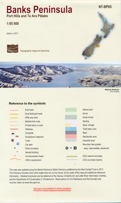
Een kaartenserie van NewTopoNZ van vrijwel alle nationale parken, meerdaagse tochten en belangrijke wandelgebieden in Nieuw Zeeland. We hebben een selectie van de kaarten op voorraad.    Het zijn bijzonder leesbare kaarten met een helder kaartbeeld in goede kleurstelling. Alle belangrijke topografische details kun je er op terugvinden: hoogtelijnen, bergtoppen, stromen en rivieren, vegatatietype, gletsjers. De kaarten zijn bruikbaar samen met GPS.    Daarnaast is er toeristische informatie toegevoegd in de vorm van symbolen (zoals bruggen, stranden, watertaxi's, uitzichtspunten en parkeerplaatsen) en staan campings en hutten aangeduid. De wandelroutes zijn ingetekend met een rode lijn, verschillend naar gemarkeerd en ongemarkeerd, zelfs afstanden tussen hutten worden vaak vermeld.    This is the only topographic map to show the whole of the Banks Peninsula on one sheet at this scale, giving emphasis to the walking tracks in this popular Christchurch recreation area.  It is very easy to read with a clear road network and full topography.   The edition incorporates the latest track changes on Te Ara Pātaka and adds the DOC and CCC Reserve boundaries.  It is printed on high-quality Polyart synthetic paper.


Verken gerelateerde categorieën

Webshop.nl maakt gebruik van cookies. Ga je verder op onze website, ga dan akkoord met het plaatsen van cookies en de verwerking van deze data door ons en vermelde partners.