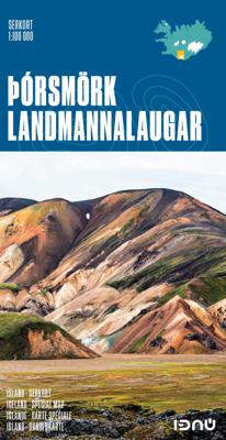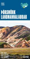
Wandelkaart 7 Porsmörk - Landmannalaugar IJsland | Ferdakort

0
Gedetailleerde wandelkaart van het zuidwestelijke deel van IJsland, met hoogtelijnen, wandelpaden (gemarkeerd en niet gemarkeerde), allerlei topografische details. This very popular map has been published regularly for over two decades. Among its features are walking trails from Landmannalaugar to Þórsmörk. The map reaches south to the glaciers an...

Verkopers met dit product

Verkoper
Bezorging
Prijs
DeZwerver.nl logo
DeZwerver.nl
2,95
21,50

Anderen bekeken ook

Wandelkaart 4 Husavik - Mývatn - Muggenmeer IJsland | Ferdakort
Gedetailleerde wandelkaart van het zuidwestelijke deel van IJsland, met hoogtelijnen, wandelpaden (gemarkeerd en niet gemarkeerde), allerlei topografische details. Deze kaart bestrijkt het gebied in het noordoosten van IJsland. High-quality shaded-relief map of a popular region in Iceland. It includes the town of Húsavík, the Aðaldalur valley and the Mývatn area, as the well as the Jökulsárgljúfur National Park. Provides up-to date road information and containsa vast number of place-names.   Size: 66 x 78 cm / Weight: 74 g.   Languages: Icelandic, English, German and French  
21,50
Wandelkaart Tour & Trail Madeira | Discovery Walking Guides
Goed gedetallieerde wandelkaart van Madeira, schaal 1:40.000, scheur en watervast papier. Wandelroutes staan ingetekend. Our large 1:40,000 scale, combined with splitting the island into East and West with a generous overlap, produces double sided map whose total size is 840mm by 600mm and folds to 235mm by 120mm. You get the most detailed map of Madeira that is produced including our 'Tour & Trail' level of detail ranging from major roads to secondary roads to minor roads to streets and camino rural narrow country roads, plus dirt roads and walking trails. Altitude background colouring is designed to clearly show the altitude range when travelling across the island by car or on foot. 100 metre and 50 metre contours are clearly shown on the map along with a large number of individual height points and all of the official 'Trig' points. Tour & Trail attention to detail is legendary as is our useful symbol range including miradors, picnic areas, petrol stations, bar/restaurants and park…
15,95
Wandelkaart Tour & Trail Costa Blanca mountains | Discovery Walking Guides
Thanks to all the walking research carried out by Charles Davis for his new Walk! the Costa Blanca Mountains guide book plus gps ground surveys carried out by David & Ros Brawn we have been able to a new Costa Blanca Mountains Tour & Trail Super-Durable Map. This new Costa Blanca Mountains Tour & Trail Super-Durable Map is the essential purchase for everyone looking to explore the exciting mountainous hinterland on the Costa Blanca. Whether you are exploring on foot, bike or horse this is your first choice map for accurate navigation on roads and as soon as you leave the tarmac. Scale 1:40,000 2.5cms = 1km. Map size; double-sided 780mm by 600mm folded to 21cm by 12cm. Roads; Motorway, major roads, secondary roads, minor roads & tarmacked lanes including latest road numbering system. Tracks & Trails; Unsurfaced (dirt) roads and walking trails. Heights; 100 & 20 metre contours, height & trig points in metres, height background colours in 200 metre colour bands. UTM 1km Grid with WGS84 D…
15,95
Wandelkaart Tour & Trail Western Crete - West Kreta | Discovery Walking Guides
Goede, scheur- en watervaste, wandelkaart van west Kreta, met name het wandelgebied rond Lefka Ori en de Samaria Kloof. For your best adventures, use the best map. Water-proof, split-proof, tear-proof. Western Crete Tour & Trail Super-Durable Map is simply the toughest, most accurate, easy to read, easy to use map that you can buy at any price. A large 960mm by 694mm double sided map sheet at 1:40,000 scale covers area of over 1600km2, from Paleochora in the west to Preveli beach in the east. The map covers the most important hiking regions in the western Crete, including the famous Samaria Gorge, Lefka Ori (White Mountains) and much more. Our legendary 'Tour & Trail' level of detail ranges from major roads to secondary roads to minor roads to streets and narrow country roads, plus dirt roads, tracks and walking trails. Place names are in English and Greek to aid your navigation. Altitude shading is designed to clearly show the altitude range when travelling across the island by car o…
15,95
Wandelkaart Tour & Trail Lefkada - Paxos - Antipaxos - Lefkas | Discovery Walking Guides
For your best adventures, use the best map. Water-proof, split-proof, tear-proof, adventure-proof. Lefkada, Paxos & Antipaxos Tour & Trail Super-Durable Maps are simply the toughest, most accurate, easy to read, easy to use maps of these Ionian islands that you can buy at any price.   A large 840mm by 690mm double sided map sheet has Lefkada at 1:40,000 scale on one side, with Paxos and Antipaxos islands at 1:25,000 scale on the other side. The Lefkada map sheet also covers Meganisi island and a large area of the adjacent mainland peninsula (as far as Voulkaria lake in the NE and Pogonias village in the SE) with its interesting castles and ancient sites. The peninsula is connected to Lefkada via a road bridge, which offers an additional 100km2 of the mainland for more touring and discovering. We have also included a street plan of the capital town Lefkada at 1:7,000 scale.   DWG's special concertina map fold makes our map easy to open and easy to refold to its 230mm by 120mm pocket si…
15,95
Reisgids Rough Guide Pocket Reykjavik | Rough Guides
Een kleinere versie in zakformaat van de grotere versies van de Rough Guides. Als altijd weer vol met goede informatie over cultuur en praktische zaken. Achterin een kaart van de stad. This compact, pocket-sized Reykjavík travel guidebook is ideal for travellers on shorter trips and those trying to make the most of Reykjavík. It’s light, easily portable and comes equipped with a pull-out map.    This Reykjavík guidebook covers: Lækjartorg, Austurstræti, Austurvöllur, Aðalstræti, Hafnarstræti, Tryggvagata, The Harbour, Tjornin, Bankastræti, Hallgrimskirkja, Oskjuhlid, Hafnarfjörður, Reykjanes Peninsula, Blue Lagoon.   Inside this Reykjavík travel book you will find:       Curated recommendations of places – main attractions, off-the-beaten-track adventures, child-friendly family activities, chilled-out breaks in popular tourist areas    Things not to miss – The Golden Circle, Seljalandsfoss, Skógar, Heimaey, Þjórsárdalur, Landmannalaugar, Þórsmörk, Landmannalaugar, Þórsmörk …
13,95
Wandelkaart Tour & Trail Cape Verde: Sal & Boa Vista | Discovery Walking Guides
Scheur- en watervaste wandelkaart van de Kaapverdische eilanden Sal & Boa Vista met hoogtelijnen en graden. or your best adventures, use the best maps. Water-proof, split-proof, tear-proof, adventure-proof. Sal and Boa Vista Tour & Trail Super-Durable Maps are simply the toughest, most accurate, easy to read, easy to use maps of these two islands that you can buy at any price.   A large 840mm by 690mm double sided map sheet has Sal at 1:40,000 scale on the cover side, with Boa Vista at 1:45,000 scale on the reverse. There are also street plans of Espargos, Santa Maria (Sal) and Sal Rei (Boa Vista) at 1:10,000 scale. Our special concertina map fold makes our map easy to open and easy to refold to its 230mm by 120mm pocket size.   Our legendary 'Tour & Trail' level of detail ranges from major roads to secondary roads to minor roads to streets and narrow country roads, plus dirt roads, tracks and walking trails. Altitude shading each 100 metres is designed to clearly show the altitude ra…
16,95
Reisgids Iceland - IJsland | Lonely Planet
De perfecte reisgids voor IJsland, zowel de georganiseerde als de zelfstandige reiziger. Naast een algemene inleiding van het land / streek vol met praktische informatie over hoe je er het beste kunt reizen: slapen, eten, vervoer, excursies ... alles kun je er in vinden. Discover popular and off the beaten track experiences from sailing among majestic icebergs in Iceland's most famous glacier lagoon, Jökulsárlón; to devouring lobster at the authentic small-town festival of Humarhátíð; and exploring Þingvellir National Park on horseback.   Build a trip to remember with Lonely Planet's Iceland Travel Guide:   Our classic guidebook format provides you with the most comprehensive level of information for planning multi-week trips Updated with an all new structure and design so you can navigate Iceland and connect experiences together with ease Create your perfect trip with exciting itineraries for extended journeys combined with suggested day trips, walking tours, and activities t…
24,95
Wegenatlas IJsland met stadsplattegronden | Ferdakort
Super handige kleine wegenatlas van IJsland (schaal 1:500.000) met vooral een enorme hoeveelheid plattegronden van steden en dorpen, enkele themakaarten en een groot register. De kaarten zijn uitstekend leesbaar en de atlas in in een mooie ringband uitgevoerd.  Road Atlas of Iceland at 1:500,000 from Ferðakort, published in a handy 15x25cm spiral-bound format, with an index of over 3,000 entries, a comprehensive distance table, 46 street plans including Reykjavik and several thematic map sincluding cultural heritage and geology.   The whole of Iceland is covered at 1:500,000 with the road network distinguishing between paved and gravel roads, and showing which small local roads are maintained by the country’s government. Fords, locations of petrol stations, driving distances and car ferry routes are marked. National parks and other protected areas are highlighted and symbols mark locations of various places of interest: different types of tourist accommodations including campsites, re…
30,95
Natuurgids Botanical map Ijsland | Mal og Menning
The botanical map provides clear and accessible information on Iceland's main plants. It shows 78 flowering plants, together with distribution maps and information on size, habitat and season of flowering. The map also includes pictures of Iceland's principal cryptograms (spore-bearing plants), grasses, algae, lichens and fungi. The map's sources include Flowering Plants and Ferns of Iceland by Hörður Kristinsson. The watercolour illustrations areby Jón Baldur Hlíðberg, one of the authors of the Mál og menning Birdwatchers' Map. The botanical map is indispensable to all lovers of Icelandic nature, who wish to learn about Icelandic flora on their travels.
22,50

Klanten-reviews van Wandelkaart 7 Porsmörk - Landmannalaugar IJsland | Ferdakort

Er zijn nog geen beoordelingen voor dit productBen jij de eerste die een review plaatst?

Meer over Wandelkaart 7 Porsmörk - Landmannalaugar IJsland | Ferdakort

Productomschrijving

Gedetailleerde wandelkaart van het zuidwestelijke deel van IJsland, met hoogtelijnen, wandelpaden (gemarkeerd en niet gemarkeerde), allerlei topografische details.

This very popular map has been published regularly for over two decades. Among its features are walking trails from Landmannalaugar to Þórsmörk. The map reaches south to the glaciers and includes the walking trail over Fimmvörðuháls.  
  • Scale: 1:100 000
  •  
  • Published: 2017
  •  
  • Size: 84,5 x 62 cm / Weight: 75 g.
  •  
  • Languages: Icelandic, English, German and French

Verken gerelateerde categorieën

Webshop.nl maakt gebruik van cookies. Ga je verder op onze website, ga dan akkoord met het plaatsen van cookies en de verwerking van deze data door ons en vermelde partners.