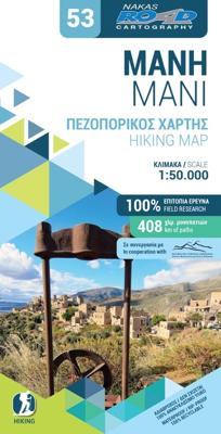
Wandelkaart 53 Mani hiking map | Road Editions

0
Gedetailleerde wandelkaart die 2 mooie gebieden combineert: op de ene kant Mani en op de andere zijde het berggebied rond Mt. Taygetos. Met hoogtelijnen, ook de kleinere wegen en grotere wandelpaden.  Hiking map in Mani and around Mount Taygetos 1/50 (1cm = 500m) published by Cartography Road. With panoramic routes, trails and a map of the Poseido...

Verkopers met dit product

Verkoper
Bezorging
Prijs
DeZwerver.nl logo
DeZwerver.nl
2,95
9,95

Anderen bekeken ook

Nieuw
Wandelkaart 08.10 Exo Mani | Anavasi
Uitstekende wandelkaart op scheur- en watervast papier van het wandelgebied rond Kardamyli maar ook nog met Agios Nikolaos. De wandelpaden staan er op ingetekend, zo ook alle bezienswaardigheden als klooster, kastelen en meerdere opgravingen.  Mani is the middle and southernmost peninsula of the Peloponnese and is split between Laconia and Messinia. Exo Mani is the name of the northwestern part, which belongs to the prefecture of Messinia. Exo Mani preserves a treasure trove of Byzantine and post-Byzantine churches and castles in breathtaking landscapes.The new map covers the entire Exo Mani, the are formerly covered by the three older maps "Verga-Kampos", "Kardamyli-Stoupa" and "Agios Nikolaos-Trachila. " The area has wonderful cobbled paths ideal for walking all year round.
11,95
Wandelkaart 8.1 Mt. Taygetos - Peloponnesos | Anavasi
Uitstekende topografische kaarten van een deel van Griekenland: zonder meer hele goede kaarten voor wandeltochten in een onbekend stuk Griekenland! Ze zijn gedrukt op scheurvast en watervast papier op een schaal van 1:25.000 met een UTM grid voor GPS gebruikers. Op de meeste kaarten is geven de hoogtelijnen een interval van 20m. aan. Met schaduwkleuren, punten met hoogtemeters, bronnen, riviertjes en landgebruik geven ze de topografie van het land goed weer. Lokale voetpaden, herbergen en berghutten zijn duidelijk weergegeven. De wegen zijn in gradaties getekend: verhard en onverhard, groot en klein, met afstanden en benzinepompen. Toeristische bezienswaardigheden als kloosters, grotten, kerken etc staan ingetekend. Achterop de kaart worden suggesties gegeven voor wandelroutes met wandeltijd in uren. This is not just a hiking map, this is a hiking guide AND 1: 25 000 map.   Taygetos extends as 70 km of magnificent massif anchoring the southern tip of Greece. From a dense network of ch…
25,95
Wegenkaart - landkaart 216 Skyros | Road Editions
Gedetailleerde wegenkaart met aanduiding van de wandelwegen, lijst van hotels en toeristische informatie. Voor alle doeleinden een zeer geschikte kaart. At last, a reliable and accurate map of Skyros island is available to the demanding traveler! Although Skyros(located in the central Aegean Sea, 22 nautical miles east of Evia Prefecture) is not a popular touristic destination, ROAD Editions published this map to contribute to the touristic development of this beautiful greek island. This Skyros island map incorporates the new specifications of ROAD Editions' Greek Islands Map Series: the backside of the map is a mini travel guide in full color, with many images and all the nessesary information on the touristic sights and the individual character of this island. It also includes a complete list of the hotels and rooms to let in the island, many usefull telephone numbers, and a note on the island's history. The map of Skyros presents the complete road network of the island, against a …
9,95
Wegenkaart - landkaart 215 Samothraki - Samothraki | Road Editions
Gedetailleerde wegenkaart met aanduiding van de wandelwegen, lijst van hotels en toeristische informatie. Voor alle doeleinden een zeer geschikte kaart. At last, a reliable and accurate map of Samothraki island is available to the demanding traveler! Although Samothraki (located in the the northeastern corner of the Aegean Sea) is not a popular touristic destination, ROAD Editions published this map to contribute to the touristic development of this beautiful greek island. This Samothraki island map (first edition: July 2005) incorporates the new specifications of ROAD Editions' Greek Islands Map Series: the backside of the map is a mini travel guide in full color, with many images and all the nessesary information on the touristic sights and the individual character of this island. It also includes a complete list of the hotels and rooms to let in the island, many usefull telephone numbers, and a note on the island's history. The map of Samothraki presents the complete road network o…
9,95
Wandelkaart Trekking map Aconcagua | TerraQuest
Gedetailleerde wandelkaart - trekking map van de Aconcagua en omgeving. Handig uitgevoerd: geplastificeerd maar toch makkelijk om te slaan en op te vouwen met de gewenste kant voor. De wandelroutes staan ingetekend, zo ook de berghutten en kampen. Dé kaart om de hoogste berg van Zuid Amerika te beklimmen. Laminated topographic map of Mount Aconcagua (Argentina) published by Terra Quest in 2013. Waterproof and tear-resistant, contoured and GPS compatible map, providing coverage of the Aconcagua Provincial Park with access from the road linking Punta de Vascas, Los Penitentes, Puente del Inca and the Cristo Redentor Tunnel crossing to Chile.   The map divides the area north/south with a good overlap between the sides, extending north to Cerro La Mano on the northern boundary of the park, and south of the road to include Cerro Panitentes. A hiking map characterized by topographic data (contours). An overprint highlights the approach routes to Aconcagua, indicating main trails and difficu…
18,50
Nieuw
Wandelkaart Trekking map Drakensbergen - Zuid Afrika | TerraQuest
Geplastificeerde trekking-kaart. Relatief zeer gedetailleerd. Het Ukhahlamba Park ligt op de grens van Zuid-Afrika en Lesotho met de hoogste berg en het meest interessante gebied van de Draak. Met wandelroutes, toeristische info, GPS coordinaten in WGS-84. Hiking map of the Drakensberg in the Ukhahlamba Park, on the South Africa and Lesotho border. Waterproof and tear resistant map published by Terraquest. The map is double-sided and covers the park in two overlapping sections. Coverage extends north-west to include the Royal Natal National Park. The map covers the entire Ukhahlamba Park - the highest in the Drakensberg area.   The map is distinguished by its topographical accuracy (contour) and the detailed content focused on tourism (symbols show locations of hotels, mountain refuges and campsites, bivouac and picnic places, restaurants, car parks and petrol stations, medical facilities, viewpoints, etc...) The map shows rural roads and footpaths, and highlights trekking trails indi…
18,50
Wegenkaart - landkaart 2 Peloponnese - Peloponnesos | Anavasi
De nieuwe editie van de kaart van de Peloponnesus komt met veel verbeteringen. De grotere schaal maakt het veel leesbaarder en laat gedetailleerde informatie van de kaart zien: Uitgebreid weg- en vestigingsnetwerk. Tal van archeologische sites die voor het eerst op een kaart worden gepubliceerd. Stranden, kamperen, jachthavens, berghutten en de loop van de E4 en de belangrijkste nationale paden 31, 32 en 33. En een innovatie: 10 suggesties voor unieke sites om te bezoeken aan de zijkant van de kaart. Road and touring map of the Peloponnese in scale 1:200 000. On the map find ideas for 10 top nature destinations. Planning a road trip in the Peloponnese? This is the map to take with you. It shows all road categories, to the last dirt road. Every settlement, stating their original name, when known. Plenty of archaeological sites published for the first time on a map. Beaches, camping, marinas, mountain refuges and the course of the E4 and the major national paths 31, 32 and 33. Map corre…
11,95
Nieuw
Wandelkaart 406 Crete - Kreta | Road Editions
Uitstekende wandelkaart van een deel van Kreta. De kaart is gedrukt op watervast en onverscheurbaar papier. hierdoor gaat deze veel langer mee! De wandelkaart heeft alle noodzakelijke details voor wandelen of fietsen: naast de topografische informatie als hoogtelijnen, alle plaatsnamen (zowel Grieks als Europees schrift), het wegennet, rivieren en stroompjes, nationale parken etc is er ook veel informatie over de toeristische aspecten als stranden, kloosters, campings en afstanen tussen dorpen of steden. Voor de wandelaars is relevant dat de E4, het bekende lange-afstandswandelpad, staat ingetekend alsmede andere wandelroutes. Sporadisch staan ook fietsroutes ingetekend. ROAD Cartography map, was created upon intensive fieldwork and using GIS (Geographical Information Systems) software, which results all geographic information with great accuracy. Contains every single road, trails, special routes for cycling and scenic routes, villages, attractions and plenty of other useful informat…
9,95
Wandelkaart 403 Crete - Kreta | Road Editions
Uitstekende wandelkaart van een deel van Kreta. De kaart is gedrukt op watervast en onverscheurbaar papier. hierdoor gaat deze veel langer mee!   De wandelkaart heeft alle noodzakelijke details voor wandelen of fietsen: naast de topografische informatie als hoogtelijnen, alle plaatsnamen (zowel Grieks als Europees schrift), het wegennet, rivieren en stroompjes, nationale parken etc is er ook veel informatie over de toeristische aspecten als stranden, kloosters, campings en afstanen tussen dorpen of steden.   Voor de wandelaars is relevant dat de E4, het bekende lange-afstandswandelpad, staat ingetekend alsmede andere wandelroutes. Sporadisch staan ook fietsroutes ingetekend. ROAD Cartography map, was created upon intensive fieldwork and using GIS (Geographical Information Systems) software, which results all geographic information with great accuracy. Contains every single road, trails, special routes for cycling and scenic routes, villages, attractions and plenty of other useful info…
9,95

Klanten-reviews van Wandelkaart 53 Mani hiking map | Road Editions

Er zijn nog geen beoordelingen voor dit productBen jij de eerste die een review plaatst?

Meer over Wandelkaart 53 Mani hiking map | Road Editions

Productomschrijving

Gedetailleerde wandelkaart die 2 mooie gebieden combineert: op de ene kant Mani en op de andere zijde het berggebied rond Mt. Taygetos. Met hoogtelijnen, ook de kleinere wegen en grotere wandelpaden. 

Hiking map in Mani and around Mount Taygetos 1/50 (1cm = 500m) published by Cartography Road. With panoramic routes, trails and a map of the Poseidon sanctuary Tenaron. 

Productinformatie

    Verken gerelateerde categorieën

    Webshop.nl maakt gebruik van cookies. Ga je verder op onze website, ga dan akkoord met het plaatsen van cookies en de verwerking van deze data door ons en vermelde partners.