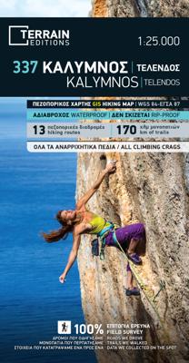
Wandelkaart 337 Kalymnos | Terrain maps

0
Gedetailleerde wegenkaart en wandelkaart met alle kleine wegen, wandelpaden, hoogtelijnen en toeristische informatie aangegeven. Alle tekst is tweetalig in Engels en Grieks en de waterproof kaart is geschikt voor gebruik met GPS. This is a great map because: It is the only map featuring the climbing crags of Kalymnos completely and accurately. Fa...

Alle aanbiedingen van dit product

Verkoper
Bezorging
Prijs
DeZwerver.nl logo
DeZwerver.nl
2,95
13,95

Klanten-reviews van Wandelkaart 337 Kalymnos | Terrain maps

Er zijn nog geen beoordelingen voor dit productBen jij de eerste die een review plaatst?

Meer over Wandelkaart 337 Kalymnos | Terrain maps

Productomschrijving

Gedetailleerde wegenkaart en wandelkaart met alle kleine wegen, wandelpaden, hoogtelijnen en toeristische informatie aangegeven. Alle tekst is tweetalig in Engels en Grieks en de waterproof kaart is geschikt voor gebruik met GPS.

This is a great map because:

  • It is the only map featuring the climbing crags of Kalymnos completely and accurately. Fabulous cliffs and impeccable organization have made Kalymnos the No 1 rock climbing destination worldwide. This is the first map of Kalymnos to accurately feature all climbing crags on the island, with no omissions or errors, including crags equipped through May of 2009! There are two more maps of Kalymnos in the market, but if you can compare them with the SKAI map of Kalymnos – you will immediately see how far ahead our map is. One of those maps features a few of the climbing crags with symbols on the back side. The other features climbing crags on the actual map but with several errors, inconsistencies and considerable omissions. 
  • It is waterproof and rip-proof. You can fold and unfold it a thousand times, fold it in irregular ways, dunk it in the sea or leave it out in the rain. This map is indestructible! 
  • It is the first time the island’s entire coastline is mapped. Cartography was done with TERRAIN’s specially equipped and staffed cartographic vessel. This means that you can locate all beaches of the island, down to the tiniest cove! 
  • It features the most complete road network and the trails of Kalymnos with accuracy and precision, since the cartographers of TERRAIN walked them one-by-one. The length of all trails is measured in kilometers so you can estimate the duration of your hike, plus the descriptions of the 13 most important trails are featured on the back. Certain trails appearing on other maps but not on our own are either the trails which run through open terrain, or the extremely rough trails, which would put the average hiker at risk –hence, we opted not to include them in our SKAI map of Kalymnos. In contrast, our map exclusively features the most useful trails, which are those leading to the island’s climbing crags.

Productinformatie

    Verken gerelateerde categorieën

    Webshop.nl maakt gebruik van cookies. Ga je verder op onze website, ga dan akkoord met het plaatsen van cookies en de verwerking van deze data door ons en vermelde partners.
