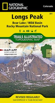
Wandelkaart 301 Longs Peak / Bear Lake / Wild Basin / Rocky Mountain NP | National Geographic

0

Verkopers met dit product

Verkoper
Bezorging
Prijs
DeZwerver.nl logo
DeZwerver.nl
2,95
17,95

Anderen bekeken ook

Wandelkaart 200 Rocky Mountain National Park | National Geographic
Zeer gedetailleerde wandel- en trekkingkaart voor het Rocky Mountain Nationaal Park in Colorado. Met ingetekende wandelroutes, afstanden, kampeerplekken en toeristische informatie en vele handige tips. GPS geschikt door UTM Grid. Water en scheurvast. Coverage includes Rocky Mountain National Park, Arapaho and Roosevelt National Forest, Never Summer Wilderness, Arapaho National Recreation Area, and the cities of Granby and Estes Park. Revisions to this map include easy-to-read trail mileage and markers, hiking-only and hike and horse trails are easily distinguished, Federal, State and Private lands are clearly marked, the Continental Divide Trail is highlighted, and the map is keyed to the updated Rocky Mountain National Park Dayhiker's Guide. Includes UTM grids for use with your GPS unit.
16,95
Nieuw
Wandelkaart - Topografische kaart 803 Lake Tahoe Basin | National Geographic
Prachtige geplastificeerde kaart van het bekende nationaal park. Met alle recreatieve voorzieningen als campsites, maar ook met topografische details en wandelroutes ed. Door uitgekiend kleurgebruik zeer prettig in gebruik. Scheur en watervast! The largest alpine lake in North America, Lake Tahoe straddles the border of California and Nevada. It's unusually clear waters and surrounding Sierra Nevada mountains make it one of the most beautiful lakes in the world. National Geographic's Trails Illustrated map of Lake Tahoe Basin delivers unmatched detail and valuable information to assist you in enjoying the year-round recreational opportunities this region offers. Expertly researched and created in partnership with local land management agencies, this map includes Desolation Wilderness; Prosser Creek Reservoir; Granite Chief and Mount Rose wilderness areas; and El Dorado, Humboldt-Toiyabe and Tahoe National Forests. In addition, the following state parks are included: Donner Memorial, E…
17,95
Nieuw
Wandelkaart 305 Yellowstone Lake | National Geographic
Prachtige geplastificeerde kaart van het nationaal park. Met alle recreatieve voorzieningen als campsites, maar ook met topografische details en wandelroutes ed. Door uitgekiend kleurgebruik zeer prettig in gebruik. Scheur en watervast! National Geographic's Trails Illustrated map of the Yellowstone Lake area of Yellowstone National Park is designed to meet the needs of outdoor enthusiasts with unmatched detail of the south-east section of the national park. Expertly researched and created in partnership with local land management agencies, this map features key points of interest including Yellowstone lake shown with contours and bathe metric shading, Lake Village, Grant Village, East Entrance Station, Heart Lake, Bridger-Teton National Forest, Shoshone National Forest, Teton Wilderness, and North Absaroka Wilderness.   With many miles of mapped trails and marked Bear Management Zones the Yellowstone Lake map can guide you off the beaten path and back again. The clearly marked trails…
14,95
Nieuw
Wandelkaart 244 Crater Lake National Park | National Geographic
Prachtige geplastificeerde kaart van het bekende nationaal park. Met alle recreatieve voorzieningen als campsites, maar ook met topografische details en wandelroutes ed. Door uitgekiend kleurgebruik zeer prettig in gebruik. Scheur en watervast! This two-sided map includes Mazama Village, Crater Lake National Park in its entirety, portions of Umpqua National Forest, Rogue River National Forest, Winema National Forest, and Sky Lakes Wilderness, and Mount Thielson Wilderness. Trails include the Pacific Crest National Scenic Trail, Lightning Springs Trail, Bert Creek Trail, Bald Crater Loop Trail, Stuart Falls Spur Trail, trails within Sky Lakes Wilderness, as well as trails to Crater Peak, Lodgepole, Red Cone Springs, Grouse Hill, Mount Scott, and popular overlooks. The map also features a brief overview of the natural forces that formed the lake, as well as sections on backcountry regulations, trail regulations, featured recreation, and trail information for short-, medium-, and long hi…
17,95
Reisgids Rocky Mountain National Park | Moon
Hike to stunning glaciers and waterfalls, savor the solitude of the mountains, and sleep under the stars: an unforgettable adventure awaits with Moon Rocky Mountain National Park. Inside you'll find:   - Flexible Itineraries: Unique and adventure-packed ideas ranging from one day in the park to a week-long trip, with tips for family fun, winter adventures, and visiting all the glaciers. - The Best Hikes in Rocky: Detailed trail descriptions with mileage, elevation gains, individual trail maps, and backpacking options. - Experience the Outdoors: Hike the dramatic glacier-formed gorges to find jaw-dropping waterfalls and spot elk, moose, and bighorn sheep along the way. Snowshoe to a ghost town in the winter, hit the trail in autumn for stunning fall colour, or catch the annual Perseid meteor shower in August. Take an adventurous bike tour, try your hand at rock climbing or fishing, and set up camp for a night under the stars (and a spectacular sunrise, too!). - How to Get There: Up-to-…
23,95
Reisinspiratieboek National Geographic Atlas of Wild America | National Geographic
From the deep forests of the Canadian Northwest to the red-rock deserts of the American Southwest, North America offers a myriad of opportunities for hiking, camping, trekking, and simply enjoying the abundance of the natural world. This opulent volume highlights 41 of those wilderness locations. Filled with authoritative maps, data-driven graphics, awe-inspiring photographs, and thoughtful essays, this vivid book will feed the soul of everyone who loves wild places. Six lush chapters take readers from the eastern woodlands to the central plains, from the northern wilderness to southwestern desert lands--including key wilderness areas in Canada and Mexico. You'll discover the fascinating history of the High Peaks of the Adirondacks, learn about fossil remains on the Upper Missouri River, gaze through the rainforest canopy of Alaska's Tongass National Forest, and experience Grand Canyon Parashat's Dark Sky Park. A special section rich in maps and graphics highlights 13 thematic topic…
78,95
Nieuw
Wegenkaart - landkaart 3120 Rocky Mountains | National Geographic
Mooie kaart van de bekende kaartenmaker National Geographic. Veel details door kleurgebruik. De wegen zijn met kleuren verdeeld in drukke en minder drukke, de wegnummers zijn goed terug te vinden. De kaart onderscheidt zich van andere series door de hoeveelheid topografische details als counties, plaatsnamen en waterwegen en het bevat een register waarin het eenvoudig zoeken is. Daarnaast is de kaart gedrukt op scheur- en watervast papier. The United States Rocky Mountains Adventure Map will guide you through one of the most rugged and scenic regions in North America. Colorado, Utah, Wyoming, and Montana contain Yellowstone, Grand Teton, Glacier, Zion, Arches, Capitol Reef, Canyonlands, Mesa Verde, and Rocky Mountain National Parks along with dozens of magnificent National Monuments, Forests, and Wilderness Areas, the Continental Divide, and America’s greatest skiing, rafting, and climbing destinations. The map includes the cities of Denver, Salt Lake City, and Missoula, and Cheyenne …
17,50
Fotoboek Wild, Beautiful Places | National Geographic
National Geographic photography captures the world's most remote, exotic places in this visually stunning travel book full of scenic wonders to experience. Highlighting 50 of Earth's most pristine, scenic locales, this beautiful book is illustrated with stunning images, coupled with accessible, engaging descriptions and practical travel information. The book covers everything from otherworldly, secluded valleys to far-flung, soaring mountain ranges. National Geographic photographers share some of their favorite shots from around the world and explain how they got them, and historical photos culled from National Geographic's hallowed image archive highlight old Society explorations in rugged, distant locations, and give a glimpse into the bygone days of these exotic places.
29,95

Klanten-reviews van Wandelkaart 301 Longs Peak / Bear Lake / Wild Basin / Rocky Mountain NP | National Geographic

Er zijn nog geen beoordelingen voor dit productBen jij de eerste die een review plaatst?

Meer over Wandelkaart 301 Longs Peak / Bear Lake / Wild Basin / Rocky Mountain NP | National Geographic

Verken gerelateerde categorieën

Webshop.nl maakt gebruik van cookies. Ga je verder op onze website, ga dan akkoord met het plaatsen van cookies en de verwerking van deze data door ons en vermelde partners.