webshop.nl
Categorieën
  Sluiten

Meer National Geographic

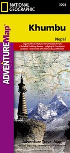
Wandelkaart 3002 trekking map Khumbu - Nepal | National Geographic

Mooie gedetailleerde topografische kaart, voorzien van veel extra info en gedrukt op water- en scheurvast materiaal. Each Adventure Map is highly detailed, incredibly durable, waterproof and tear-resistant. Stunning shaded relief brings each map to life, giving you the power to discover, plan and dream. Trail routes, villages, cultivated areas, par...
17,50

Webshops met dit product

Webshop
Bezorging
Prijs

Anderen bekeken ook

Wandelkaart 3002 trekking map Khumbu - Nepal | National Geographic
Mooie gedetailleerde topografische kaart, voorzien van veel extra info en gedrukt op water- en scheurvast materiaal. Each Adventure Map is highly detailed, incredibly durable, waterproof and tear-resistant. Stunning shaded relief brings each map to life, giving you the power to discover, plan and dream. Trail routes, villages, cultivated areas, park boundaries and points of interest make these maps essential gear. Each map includes a beautifully crafted map of the Kingdom of Nepal, inset maps of Kathmandu and Thamel, and a comprehensive index of villages, passages and peaks. Detailed topographic trekking map for the Khumbu region of Nepal. Includes coverage of Sagarmatha National Park, Makalu Barun National Park, and the western bordering foothills. Additional Details: Printed on waterproof, tear-resistant material. Borders the Langtang and Everest Base Camp Adventure Maps. Includes detailed inset maps of Kathmandu and Thamel, plus an overview map of the kingdom of Nepal.
17,50
Wandelkaart 3003 Trekking map Annapurna - Nepal | National Geographic
Mooie gedetailleerde topografische kaart, voorzien van veel extra info en gedrukt op water- en scheurvast materiaal. Each Adventure Map is highly detailed, incredibly durable, waterproof and tear-resistant. Stunning shaded relief brings each map to life, giving you the power to discover, plan and dream. Trail routes, villages, cultivated areas, park boundaries and points of interest make these maps essential gear. Each map includes a beautifully crafted map of the Kingdom of Nepal, inset maps of Kathmandu and Thamel, and a comprehensive index of villages, passages and peaks. The very name evokes majesty, mystery and magnificence! Earth's highest peaks soar above, beckoning adventurers to one of the world's most dramatic regions. Includes trail routes, villages, cultivated areas, park boundaries, and points of interest. Printed on waterproof, tear-resistant material that stands up to the rigors of travel.
17,50
Wandelkaart 3004 Adventure Map trekkingmap Langtang - Nepal | National
Each Adventure Map is highly detailed, incredibly durable, waterproof and tear-resistant. Stunning shaded relief brings each map to life, giving you the power to discover, plan and dream. Trail routes, villages, cultivated areas, park boundaries and points of interest make these maps essential gear. Each map includes a beautifully crafted map of the Kingdom of Nepal, inset maps of Kathmandu and Thamel, and a comprehensive index of villages, passages and peaks. Detailed topographic trekking map for Langtang National Park, including coverage for the Shivapuri Watershed, and the Helambu Region. Additional Details: Printed on waterproof, tear-resistant material. Includes detailed place name and locations of useful services. Reverse contains an overview map of the kingdom of Nepal and detailed insets of Kathmandu and Thamel.
16,50
Wandelkaart 3001 Adventure Map trekking map Everest Base Camp | Natio
Mooie gedetailleerde topografische kaart, voorzien van veel extra info en gedrukt op water- en scheurvast materiaal. Each Adventure Map is highly detailed, incredibly durable, waterproof and tear-resistant. Stunning shaded relief brings each map to life, giving you the power to discover, plan and dream. Trail routes, villages, cultivated areas, park boundaries and points of interest make these maps essential gear. Each map includes a beautifully crafted map of the Kingdom of Nepal, inset maps of Kathmandu and Thamel, and a comprehensive index of villages, passages and peaks. The very name evokes majesty, mystery and magnificence! Earth's highest peaks soar above, beckoning adventurers to one of the world's most dramatic regions. Includes trail routes, villages, cultivated areas, park boundaries, and points of interest. Printed on waterproof, tear-resistant material that stands up to the rigors of travel. Follow National Geographic to one of the world's most exotic locations with this c…
16,50
Wegenkaart - landkaart 3000 Adventure Map Nepal | National Geographic
Wegenkaart van Nepal met vermelding van veel bezienswaardigheden, nationale parken en attrakties. Watervast en scheurvast. National Geographic's Nepal Adventure Map is the most authoritative map for touring the country. Each waterproof and tear-resistant map provides travelers with the perfect combination of detail and perspective, highlighting points of interest for those venturing outside city centers.   This durable, folded map includes the locations of cities and towns with a user-friendly index, plus a clearly marked road network complete with distances and designations for major highways, main roads, and tracks and trails for those seeking to explore more remote regions.   The front side offers a detailed topographic and trekking map of central and eastern Nepal, including border regions with China and India. Mountaineers will stay on course with marked trails through the Himalayan Range, including Everest (the tallest mountain in the world), and the surrounding national parks an…
17,50
Reisgids Nepal | Rough Guides
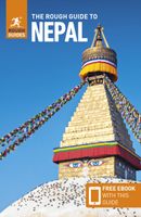
Zeer goede reisgids voor zowel de georganiseerde maar vooral voor de zelfstandige reiziger. Boordevol informatie over reizen, slapen, eten, maar ook musea en cultuur. Voor veel landen meestal completer en beter dan de Lonely Planet. This practical travel guide to Nepal features detailed factual travel tips and points-of-interest structured lists of all iconic must-see sights as well as some off-the-beaten-track treasures. Our itinerary suggestions and expert author picks of things to see and do will make it a perfect companion both, ahead of your trip and on the ground. This Nepal guide book is packed full of details on how to get there and around, pre-departure information and top time-saving tips, including a visual list of things not to miss.   Our colour-coded maps make Nepal easier to navigate while you're there. This guide book to Nepal has been fully updated post-COVID-19 and it comes with a free eBook. The Rough Guide to Nepal covers: Kathmandu and Patan, The Kathmandu Valle…
24,95

Klanten-reviews van Wandelkaart 3002 trekking map Khumbu - Nepal | National Geographic

Er zijn nog geen beoordelingen voor dit productBen jij de eerste die een review plaatst?

Meer over Wandelkaart 3002 trekking map Khumbu - Nepal | National Geographic

Productomschrijving

Mooie gedetailleerde topografische kaart, voorzien van veel extra info en gedrukt op water- en scheurvast materiaal. Each Adventure Map is highly detailed, incredibly durable, waterproof and tear-resistant. Stunning shaded relief brings each map to life, giving you the power to discover, plan and dream. Trail routes, villages, cultivated areas, park boundaries and points of interest make these maps essential gear. Each map includes a beautifully crafted map of the Kingdom of Nepal, inset maps of Kathmandu and Thamel, and a comprehensive index of villages, passages and peaks. Detailed topographic trekking map for the Khumbu region of Nepal. Includes coverage of Sagarmatha National Park, Makalu Barun National Park, and the western bordering foothills. Additional Details: Printed on waterproof, tear-resistant material. Borders the Langtang and Everest Base Camp Adventure Maps. Includes detailed inset maps of Kathmandu and Thamel, plus an overview map of the kingdom of Nepal.

Productspecificaties

Artikelnummer(s)
Brand
National Geographic
Webshop.nl maakt gebruik van cookies. Ga je verder op onze website, ga dan akkoord met het plaatsen van cookies en de verwerking van deze data door ons en vermelde partners.