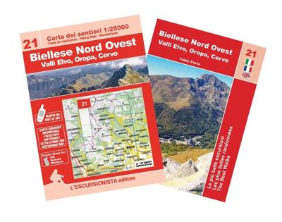
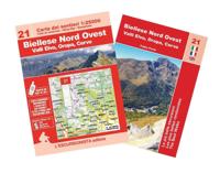
Wandelkaart 21 Biellese Nord Ovest - Valli Elvo, Oropa, Cervo | L'Escursionista editore

0
Voor weinig gebieden in Italië zijn echt goede wandelkaarten beschikbaar. Dit is gelukkig zo'n serie: voor de noordwestelijke Alpen van Italië, Gran Paradiso, Mont Blanc en Aosta en omgeving.     Met GPS grid uitgeruste detailkaart, schaal 1:25.000 met alle noodzakelijke wandelinformatie als ingetekende routes, Via Ferrata routes, campings, berghu...

Verkopers met dit product

Verkoper
Bezorging
Prijs
DeZwerver.nl logo
DeZwerver.nl
2,95
15,95

Anderen bekeken ook

Wandelkaart 20 Dora Baltea Canavesana - Laghi d'Ivrea | L'Escursionista editore
Voor weinig gebieden in Italië zijn echt goede wandelkaarten beschikbaar. Dit is gelukkig zo'n serie: voor de noordwestelijke Alpen van Italië, Gran Paradiso, Mont Blanc en Aosta en omgeving.   Met GPS grid uitgeruste detailkaart, schaal 1:25.000 met alle noodzakelijke wandelinformatie als ingetekende routes, Via Ferrata routes, campings, berghutten en schuilhutten, dat alles met een kaart die veel topografische details kent.    Hoogtelijnen van 25 m. interval, schaduwtekeningen en goed gebruik van kleur voor bijvoorbeeld gletsjers en bossen. Naast ingetekende routes zijn er ook gewone voetpaden op te vinden.    Bijgeleverd wordt (niet bij elke kaart) een kleine brochure met wandelmogelijkheden in dat bepaalde gebied.   Only recently has the Dora Baltea Canavese district been discovered by tourists, foreigners for the most part. It has unique landscapes of great interest for visitors. Located at the opening of the Aosta valley, it is geographically distinct. Running along its side an…
15,95
Wandelgids Walk! La Gomera | Discovery Walking Guides
La Gomera is the ultimate get-away-from-it-all island: easy-going, unspoilt, friendly, isolated from the hustle and bustle of modern living, and so laid back it’s virtually supine - even the volcanoes have been dormant for millions of years. The walks, however, are a bit more energetic. For the new 4th edition of Walk! La Gomera Charles Davis has teamed up with Jan Kostura. Jan brings his wide experience and passion for the Canaries, checking, re-walking and revising existing routes, and adding a couple of his own adventures, including a new Top Three Gomeran walk. Two routes have been dropped as having become too dangerous, but the good news is that many of the more harum-scarum walks have been improved through path clearing and the addition of railings to the vertiginous stretches. Other good news is that the devastating forest fires of 2012 have proved not nearly as damaging as we feared, leaving most of our itineraries unscathed. In short, there is every reason to take off and ex…
17,50
Wandelkaart Tour & Trail Tenerife | Discovery Walking Guides
Uitstekende wandelkaart, met ingetekende wandelroutes, voor specifieke wandelgebieden van Tenerife. Let op: dit is niet een kaart van het hele eiland, maar puur en alleen voor de wandelgebieden > daar is deze kaart de beste in! Our latest hiking research on Tenerife has resulted in new editions of Walk! Tenerife and Tenerife Hikers' Super-Durable Maps. Thanks to Jan Kostura's research we have several new hiking adventures described in detail in Walk! Tenerife. Jan's gps records of his research for new routes and updating of current routes has provided the detailed information to produce our new fourth edition of Tenerife Hiker's Super-Durable Maps. Note that Tenerife Hikers' Super-Durable Maps is a collection of four 30k scale map sections on a double sided sheet of 840mm by 600mm which folds up to 220mm by 120mm. It is not a map of all of Tenerife.  In this edition you will find 30k scale maps covering Valle de Orotava, West, Anaga and Adeje/Arona - Teide printed on a double sided…
17,95
Fietskaart 10 Cycling guides North York Moors | Goldeneye
Scheur- en watervast foetskaart van de North York Moors  met ingetekende fietsroutes.   Our maps are double-sided, printed on an A2 sheet with a concertina fold. This allows for easy folding and folding, and an ease of access to the mapping. The material is rain and tear-resistant. Our early maps were designed at the scale of 2 miles to 1 inch/1:126,720. The later designs along with digitalisation are 1: 100,000. We were encouraged by the Cycle Touring Club to convert our cartography toward the cycle market (to replace the out-of-print Bartholomew series). As time and the series progressed we have added more data: The National Cycle Network routes, Regional Routes, and Traffic-Free Family Routes, as and when they are developed. These routes are in addition to the Circular Routes Goldeneye Commissioned at the outset of our publishing schedule. We are also adding to new editions; bike shops, cycle hire, and tea rooms, along with the tourist attractions already featured. Our plan is to m…
14,95
Wegenkaart - landkaart Mont Blanc & Alpen | ITMB
As far as mountains go, Mont Blanc in France and Italy, forming the border between the two countries, with Switzerland nearby, is the best known and most attractive mountain in the Alps. The peak itself is far too challenging for most climbers to attempt, but the region is dotted with ski lifts, hiking trails in the lower regions, and fascinating scenic villages. Mont Blanc tops out at 4,807.81 metres and is protected by Monte Bianco National Park in Italy. There is a long tunnel underneath the mountain joining France (near Chamonix) and Italy (near Courmayeur) and a beautiful highway along its western side (the D1506) and in Italy along its south side (SS26). There is also a Grande Route long-distance hiking trail that surrounds the mountain. We show it in its entirety, including numerous overnight stopping areas, either in towns or in mountain refuges. Naturally, skiing is a huge draw, and we include several ski lifts, all rail lines in the region, including the fabulous cog line fr…
14,95
Fietskaart 14 Cycling guides Suffolk | Goldeneye
To be confronted with the variety and complexity of the cycling routes, trails and paths in Suffolk can be a bewildering experience.  For it appears that the Suffolk County Council and the three District Councils are all trying hard to promote their areas. This is indeed encouraging for the growth of cycling, but it can be confusing.  Our purpose is to provide clear, easy to use and easy to follow, cycling maps, and to illustrate these in a comprehensive form.    Suffolk must be one of the most charming of counties to explore by bicycle. When Al Churcher delivered his routes to us at Goldeneye we couldn’t keep him quiet, such was his enthusiasm and wonder at Suffolk’s country lanes and byways. He has cycled all over the UK, Canada, Mallorca, New Zealand and Sicily, but Suffolk remained a firm favourite.    The inland scenery is not spectacular for the county’s main glory lies with its attractive villages; the local architecture jealously preserved from modern depredation. There is an …
15,95
Nieuw
Wandelgids Walking in Italy's Stelvio National Park | Cicerone
Wandelgids voor de Stelvio Nationaal Park in de Rätische Alpen ( Alpi Retiche ) ten zuiden van de Splügenpas op de grens met het Zwitserse Graubünden. Engelstalige beschrijving van 38 dagwandelingen.   Aanbevolen wandelkaarten 1:25.000 voor deze gids Wandelkaart 008 Ortles - Cevedale - Ortlergebiet | Tabacco Editrice   Wandelkaart 045 Latsch - Martell - Schlanders- Laces - Val Martello - Silandro | Tabacco Editrice   Wandelkaart 048 Val di Peio - Val di Rabbi - Val di Sole | Tabacco Editrice   The wide range of 38 summer day walks in this guide explore the renowned Stelvio National Park in the Italian Rhaetian Alps. Bordering the Dolomites to the east, and Switzerland to the west, the Stelvio is one of the largest protected areas in all of the Alps. Its unspoilt landscape ranges from valley farmland to forested hillsides and alpine meadows, and up to a wilderness of rugged glaciated summits and ridges, the highest of which is Ortler, at 3905m.   The walks, a selection of routes from e…
20,95
Nieuw
Wandelkaart - Topografische kaart 150 OS Explorer Map | Active Canterbury / Isle of Thanet | Ordnance Survey
Discover Canterbury, city of saints and kings, ancient heartland of England at the foot of the Kent Downs and the head of the River Stour Valley with its vineyards. Follow the river to the coast to discover unspoiled Deal, artistic Margate and picturesque Whitstable.  Starting in Canterbury, take the Stour Valley Walk to Sandwich and the long sweeping sand and shingle beach of Sandwich Bay  Walk the Long Rock from Whitstable to Herne Bay before taking the Thanet Coastal Path around the Isle of Thanet and its three famous Georgian and Victorian resorts of Margate, Ramsgate and Broadstairs   Take the National Trails of the England Coast Path and North Downs Way or choose from a lattice of other popular recreational paths  Met zijn 4cm voor 1 km (2 ½ cm voor 1 mijl) schaal, is de OS Explorer kaartenserie de ideale en meest gedetailleerde kaartenreeks voor mensen die graag outdoor-activiteiten zoals fietsen, wandelen, paardrijden, klimmen en watersporten.   Deze kaart is nog gedetailleerd…
25,95
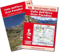
Wandelkaart 14 Valle dell'Orco, Gran Paradiso | L'Escursionista editore
Voor weinig gebieden in Italië zijn echt goede wandelkaarten beschikbaar. Dit is gelukkig zo'n serie: voor de noordwestelijke Alpen van Italië, Gran Paradiso, Mont Blanc en Aosta en omgeving. Met GPS grid uitgeruste detailkaart, schaal 1:25.000 met alle noodzakelijke wandelinformatie als ingetekende routes, Via Ferrata routes, campings, berghutten en schuilhutten, dat alles met een kaart die veel topografische details kent.    Hoogtelijnen van 25 m. interval, schaduwtekeningen en goed gebruik van kleur voor bijvoorbeeld gletsjers en bossen. Naast ingetekende routes zijn er ook gewone voetpaden op te vinden.    Bijgeleverd wordt (niet bij elke kaart) een kleine brochure met wandelmogelijkheden in dat bepaalde gebied.   Bergen en Dorpen Noasca, Ceresole Reale, Pont, Groscavallo, Gran Paradiso, Mont Taou Blanc, Piccolo Paradiso, Cima di Pertcha, Corno Bianco, Monte Unghiasse, Passo della Losa, Col du Nivolet / Colle del Nivolet, Punta Cissettaz.   With the series "the most beautiful exc…
15,95
Wandelkaart A15 Sarrabus da Costa Rei a Porto Corallo | Abies
Sarrabus is a territory that is not known by everybody yet. Here lies its charm and this has made possible to keep this environmental area out of big building speculations and also out of history. In fact it preserves little traces of the past, and paradoxically the remains from the prehistoric age are more meaningful than those back to more recent times. We can find traces from the most remote past not far from the State Road SS125, that from Muravera goes to Costa Rei, by visiting the nuraghe Murtas, the nuraghe S’Aqua Secis and the megalithic complexes of Scalas and Cuili Piras. They are about ten menhirs, almost fully intact, arranged in groups and fixed in the ground in the original orthostatic position. They have been put in relation with the position of the sun and the moon, at dawn and at sunset. In fact they were used as a very precise astronomic calendar but also for religious purposes since they represented both the masculine divinity and the fertility according to the wors…
12,95

Klanten-reviews van Wandelkaart 21 Biellese Nord Ovest - Valli Elvo, Oropa, Cervo | L'Escursionista editore

Er zijn nog geen beoordelingen voor dit productBen jij de eerste die een review plaatst?

Meer over Wandelkaart 21 Biellese Nord Ovest - Valli Elvo, Oropa, Cervo | L'Escursionista editore

Productomschrijving

Voor weinig gebieden in Italië zijn echt goede wandelkaarten beschikbaar. Dit is gelukkig zo'n serie: voor de noordwestelijke Alpen van Italië, Gran Paradiso, Mont Blanc en Aosta en omgeving.     Met GPS grid uitgeruste detailkaart, schaal 1:25.000 met alle noodzakelijke wandelinformatie als ingetekende routes, Via Ferrata routes, campings, berghutten en schuilhutten, dat alles met een kaart die veel topografische details kent.    Hoogtelijnen van 25 m. interval, schaduwtekeningen en goed gebruik van kleur voor bijvoorbeeld gletsjers en bossen. Naast ingetekende routes zijn er ook gewone voetpaden op te vinden.    Bijgeleverd wordt (niet bij elke kaart) een kleine brochure met wandelmogelijkheden in dat bepaalde gebied.   The Biellese district has a remarkable variety of landscapes. It is bounded both by the alpine chain separating it from the Valle d’Aosta and Valsesia, as well as Europe’s largest moraine relief in the southwest. Its rich history embraces herding and gold prospecting, high quality textile industry and art, along with sustainable tourism for visitors in search of genuine mountain areas combined with food and wine. It has five river valleys: the Elvo, Oropa, Cervo, Strona and Sessera (the last two will be covered in forthcoming publications). Valle Elvo, the watershed between the Biellese and Canavese districts, is vast and drenched in sun. It features streams galore, pasture and woodland, and regales breathtaking panoramas even from low altitudes. Its many places of interest include the Marian Sanctuary at Graglia (17th century), the Parco Burcina “Felice Piacenza” at Pollone, the Bessa nature reserve, an ancient Roman-era gold mine, and the Trappa monastery at Sordevolo. Valle Oropa, where religion, pastoral tradition and mountaineering come together, boasts the most important Marian sanctuary in the Alps, dedicated to the cult of the Black Madonna, along with the Sacro Monte and a botanical garden at the WWF oasis with important collections. This valley gave its name to the “Pezzata rossa di Oropa” the native bovine type that has been bred for centuries in the Biellese district for its excellent meat. Numerous mountaineering routes, climbing walls and via ferratas complete the picture. Rugged Valle Cervo enchants walkers with its fascinating vast beech woods traversed on ancient mule tracks linking the many hamlets perched on mountain flanks where time seems to stand still. The hospice-sanctuary San Giovanni Battista is noteworthy along with the nearby village of Santa Maria and its 12th-century chapel. There are walking routes with all levels of difficulty, and examples of environmentally sensitive redevelopme.   1 Mombarone, the mountain that unites   2 From the chestnut woods of Bagneri to the Trappa monastery   3 The heart of Valle Elvo   4 The old way from Biella to Oropa   5 Monte Tovo, in the heart of valle Oropa   6 The Cucco Circuit   7 From Rosazza to Piedicavallo   8 Lago della Vecchia   9 Monte Bo
 

Verken gerelateerde categorieën

Webshop.nl maakt gebruik van cookies. Ga je verder op onze website, ga dan akkoord met het plaatsen van cookies en de verwerking van deze data door ons en vermelde partners.