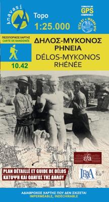
Wandelkaart 10.42 Delos - Mykonos (Mikonos) - Rheneia (Reneia) | Anavasi

0
Wandelkaart schaal 1:25.000 met hoogtelijnen, wandelpaden, toeristische informatie en UTM grid, de kaart is geschikt voor gebruik met GPS. A detailed and accurate map of the well-known island of Mykonos and its two uninhabitet neighbouring islands of Delos and Rheneia.  On the second side there is a detailed plan of the archaeological side of Delo...

Verkopers met dit product

Verkoper
Bezorging
Prijs
DeZwerver.nl logo
DeZwerver.nl
2,95
10,95

Anderen bekeken ook

Natuurgids - Vogelgids Birds and Mammals of the Galapagos | Lynx
The Galapagos archipelago is one of the most famous destinations on Earth for lovers of natural history. Straddling the equator in the Pacific Ocean c. 1000 km west of Ecuador lies ‘the world’s natural laboratory’ with its large radiations of mockingbirds and Darwin’s finches. These remote islands of volcanic origin have been colonized by a remarkable and diverse wildlife, many of the animals being quite fearless of man. With 33 endemic bird species plus 12 endemic subspecies, and six endemic mammals, the islands are unsurprisingly popular with birders and general naturalists alike. This comprehensive field guide covers all of the birds and mammals known to occur, providing the latest insights on field identification and taxonomy for challenging groups such as pelagic birds, Darwin’s finches, and cetaceans. The Galapagos is also known for its vagrants, which too are covered in detail, including several new records not published previously. Many hypothetical and potential species have …
37,95
Wandelkaart 309 Mykonos - Delos - Rinia | Terrain maps
Gedetailleerde wegenkaart en wandelkaart met alle kleine wegen, wandelpaden, hoogtelijnen en toeristische informatie aangegeven. Alle tekst is tweetalig in Engels en Grieks en de waterproof kaart is geschikt voor gebruik met GPS. This map is great because: It is the first GIS map of the island, meaning that this is the first time Mykonos is mapped with a topographic precision in proportion to the map scale.  It is waterproof and rip-proof. You can fold and unfold it a thousand times, fold it in irregular ways, dunk it in the sea or leave it out in the rain. This map is indestructible!  It is the first time the island’s entire coastline is mapped. Cartography was done with TERRAIN’s specially equipped and staffed cartographic vessel. This means that you can locate all beaches of the island, down to the tiniest cove! In fact, the special features of every single beach are recorded: whether it is sandy or pebbled, whether it features natural tree shade, water, a beach bar or organized…
11,95
Wandelkaart Tour & Trail Azores - Azoren | Discovery Walking Guides
Gedetailleerde kaart van de Azoren. Met heel veel wandelroutes, al dan niet gemarkeerd. For the best adventures, use the best map. Azores Tour & Trail Super-Durable Map is the most detailed, accurate, toughest, large scale map of these 9 islands that you can buy.    1:60,000 scale for each island, Sao Miguel at 70,000 scale, produces a double sided map sheet of 960mm by 694mm; big enough to show masses of detail but compact enough to use in the car or on the trail. Faial, Pico, Santa Maria and Sao Jorge are on the facing sheet of the map with Corvo, Flores, Graciosa, Sao Miguel and Terceira are on the reverse side. Our special concertina map fold means your map is easy to unfold, and more importantly easy to refold back to its pocket size.   You get the most detailed map of the Azores islands that is produced including our 'Tour & Trail' level of detail ranging from major roads to secondary roads to minor roads to streets and narrow country roads, plus dirt roads and walking trails. W…
15,95
Reisgids The Greek Islands - Griekse eilanden | Rough Guides
Ideal for independent travellers, this guidebook to the Greek Islands, written by destination experts, combines must-see sights with hidden gems and offers essential tips for both planning and on-the-ground adventures. It's sustainably printed to ensure environmental responsibility.   Inside this Greek Islands travel book, you'll find:   - Regional deep dive - coverage of key regions, offering a rich selection of places and experiences, and honest reviews of each one - Itinerary samples - designed for various durations and interests - Practical information - tips on how to get there and get around, use public transport, beat the crowds, save time and money, travel responsibly and more - Expert recommendations - insider advice on where to eat, drink, and stay, alongside tips for nightlife and outdoor activities - Seasonal tips - when to go to the Greek Islands, climate details, and festival highlights to plan your perfect trip - Must-See pick - a curated selection of not-to-miss sights…
22,50
Wandelkaart 6.11 Mt. Olympus | Anavasi
Uitstekende topografische kaarten van een deel van Griekenland: zonder meer hele goede kaarten voor wandeltochten in een onbekend stuk Griekenland! Ze zijn gedrukt op scheurvast en watervast papier op een schaal van 1:25.000 met een UTM grid voor GPS gebruikers. Op de meeste kaarten is geven de hoogtelijnen een interval van 20m. aan. Met schaduwkleuren, punten met hoogtemeters, bronnen, riviertjes en landgebruik geven ze de topografie van het land goed weer. Lokale voetpaden, herbergen en berghutten zijn duidelijk weergegeven. De wegen zijn in gradaties getekend: verhard en onverhard, groot en klein, met afstanden en benzinepompen. Toeristische bezienswaardigheden als kloosters, grotten, kerken etc staan ingetekend. Achterop de kaart worden suggesties gegeven voor wandelroutes met wandeltijd in uren. Hiking map to mount Olympus in a scale 1:30 000 and summit Mitikas in a scale of 1:10 000   Mount Olympus is the highest mountain in Greece with an altitude of 2917m, and in ancient times…
11,95
Wegenkaart - landkaart 107 Serifos | Road Editions
Gedetailleerde wegenkaart met aanduiding van de wandelwegen, lijst van hotels en toeristische informatie. Voor alle doeleinden een zeer geschikte kaart. The features that make this and every other ROAD island map unique are: *The coastline, hydrography and precision geophysical background based on data provided by the Hellenic Military Geographic Service and electronically processed by us for clarity and legibility. We have highlighted the mountain masses in shades of brown between the contour lines (at 20m intervals on this map) to outline clearly the relief of the island. *The beaches are indicated by a special symbol next to which we have noted their names, as well as all the roads and footpaths leading to them (since most people primarily visit the islands for the beaches!). We have even included a short text in which the island’s best beaches are concisely referred to, to save you going on a wild goose hunt in search of them. *The road network is mapped out with impressive and ex…
9,95
Wandelkaart 10.44 Kythnos | Anavasi
Het eiland Kithnos heeft twee charmante nederzettingen, Hora en Dryopida, wat zeker een bezoekje waard is. Ook heeft Kithnos prachtige stranden en een goed bewaard netwerk van paden.   De kaarten van Anavasi zijn zeer gedetailleerd, beschikken over een helder kaartbeeld en zijn uitstekende kaarten voor diverse activiteiten. Ze beschikken over vele interessante punten voor wandelaars, fietsers of andere toeristen die het gebied bezichtigen. De wandelkaarten bevatten ook een uitzonderlijke reliefaanwijzing, verschillende vormen van gewassen en andere topografische details.   Kythnos, the second in the series of the islands of the western Cyclades, after Kea, has two charming settlements, Hora and Dryopida, wonderful beaches and a well preserved network of trails, whose maintenance and waymarking has started. The new detailed map of Anavasi depicts as always with precision and detail roads and trails, while professor of archeology  Alexander Mazarakis Ainian and the great connoisseur of …
9,95
Wandelkaart 11.14 Psiloritis (Mt. Idha) | Anavasi
Uitstekende topografische kaarten van een deel van Griekenland: zonder meer hele goede kaarten voor wandeltochten in een onbekend stuk Griekenland! Ze zijn gedrukt op scheurvast en watervast papier op een schaal van 1:30.000 met een UTM grid voor GPS gebruikers. Op de meeste kaarten is geven de hoogtelijnen een interval van 20m. aan. Met schaduwkleuren, punten met hoogtemeters, bronnen, riviertjes en landgebruik geven ze de topografie van het land goed weer. Lokale voetpaden, herbergen en berghutten zijn duidelijk weergegeven. De wegen zijn in gradaties getekend: verhard en onverhard, groot en klein, met afstanden en benzinepompen. Toeristische bezienswaardigheden als kloosters, grotten, kerken etc staan ingetekend. Achterop de kaart worden suggesties gegeven voor wandelroutes met wandeltijd in uren. English description: Mt Psiloritis dominates the center of the island and the hearts of the Cretan people. It is an imposing, steep and rugged mountain, the place of upbringing of Zeus, o…
11,95
Wegenkaart - landkaart Slovenie - Slovenia & Croatian coast | ITMB
ITMB have visited Slovenia several times and find it to be an interesting and scenic part of Europe with modern and well-maintained hotels, restaurants and roads, with prices being much more affordable than in neighbouring countries to the west. As the country is not particularly large, we have limited our country coverage to one side of the sheet, with a detailed inset map of Ljubljana. The other side is a lovely map of the Dalmatian Coast. Now that Croatia is part of the EU, border limitations with the rest of western Europe have been removed and driving from Italy or Slovenia southward towards Dubrovnik is easy. The map shows the Pula Peninsula, the coastal islands of Cres, Brac, and Havar, and resort communities such as Zadar, Split, and medieval Dubrovnik. The new coastal motorway is mostly complete, but political difficulties are forcing an expensive tunneling project to by-pass part of Bosnia. Once completed, the highway will stretch to the Montenegrin border and become a major…
13,95
Wandelkaart 5 Thraki-Aegan Noord anavasi - Thraki Aegan North | Anavasi
The Thraki-North Aegean map guides us to areas of Greece with a rich history and important ecosystems. On the one side, Eastern Macedonia & Thrace where Ancient, Byzantine and Ottoman monuments coexist with the virgin forests of the Rhodope mountains, precious wetlands and the birds of prey sanctuary of Dadia. On the other side, the islands of the North Aegean, Thassos, Samothraki, Limnos, Lesvos, Chios and the smaller Ai Stratis and Psara complete the wonderful mosaic of nature and culture, as this NE edge of Greece has been through time a bridge between East and the West.  
11,95

Klanten-reviews van Wandelkaart 10.42 Delos - Mykonos (Mikonos) - Rheneia (Reneia) | Anavasi

Er zijn nog geen beoordelingen voor dit productBen jij de eerste die een review plaatst?

Meer over Wandelkaart 10.42 Delos - Mykonos (Mikonos) - Rheneia (Reneia) | Anavasi

Productomschrijving

Wandelkaart schaal 1:25.000 met hoogtelijnen, wandelpaden, toeristische informatie en UTM grid, de kaart is geschikt voor gebruik met GPS.

A detailed and accurate map of the well-known island of Mykonos and its two uninhabitet neighbouring islands of Delos and Rheneia.  On the second side there is a detailed plan of the archaeological side of Delos (in a scale of 1:1250) with texts and reconstitutions of remarkable buildings.

Verken gerelateerde categorieën

Webshop.nl maakt gebruik van cookies. Ga je verder op onze website, ga dan akkoord met het plaatsen van cookies en de verwerking van deze data door ons en vermelde partners.