Productomschrijving
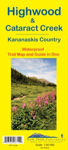
Gedetailleerde kaart van dit prachtige gebied; deze kaart is geplastificeerd, scheur- en watervast. Gem Trek’s Highwood & Cataract Creek map meets the needs of visitors looking to explore the southern portion of Kananaskis Country. Whether you are touring along the roads or heading into the backcountry, you’ll find the waterproof and tear-resistant Highwood & Cataract Creek map to be an invaluable tool. This map features detailed cartography, accurate hiking trails with distances, and details such as logging roads, campgrounds, equestrian routes, picnic areas, and fire lookouts. On the back are descriptions of the most popular hiking trails, as well details of services such as campgrounds and visitor centres. The Highwood & Cataract Creek map covers the southern portion of Alberta’s Kananaskis Country, from Sheep River Falls in the north to Plateau Mountain in the south. It extends coverage south where the Bragg Creek & Sheep Valley map leaves off, and east of the Kananaskis Lakes map coverage. It includes hiking and equestrian trails southeast of Highwood Pass accessed by Highways 40, 541, 940 and 542 (Johnson Creek Trail). Popular hiking trails on the Highwood & Cataract Creek map include Sheep River Trail, Junction Fire Lookout, Picklejar Lakes, Mt. Lipsett, Mist Ridge, Zephyr Creek, Grass Pass, Bull Creek Hills, Mt. Burke and Raspberry Ridge. A 1:50,000-scale inset map on the back increases coverage south to take in the trails accessed from Highways 940 and 542, including Pasque Mountain, Plateau Mountain, Hailstone Butte Fire Lookout and Indian Graves Ridge. The Highwood & Cataract Creek map includes: waterproof and tear-resistant paper contour lines at 25-metre (80-foot) intervals relief shading to better show the topography full colour on both sides hiking trails – with trail names and trail distances marked mountain biking trails – with trail names and distances marked hydrology – rivers, rapids and waterfalls mountain names and all available mountain elevations all campgrounds points of interest and attractions picnic areas highway viewpoints

