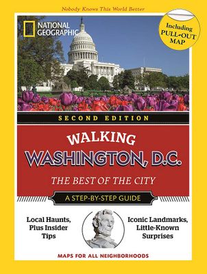
Wandelgids Walking Washington D.C. | National Geographic

0
Discover the best of Washington, D.C. with this handy guide, through 13 itineraries with step-by-step maps to help you explore its lively, eclectic neighborhoods. In a practical pocket format, the guide was written by an expert travel writer and enriched by the best images. The simple fact that Washington, D.C., is the capital of the United States...

Verkopers met dit product

Verkoper
Bezorging
Prijs
DeZwerver.nl logo
DeZwerver.nl
niet bekend
19,95

Anderen bekeken ook

Wandelgids 1512 Topographic Map Guide Appalachian Trail - Mount Carlo to Pleasant Pond | National Geographic
Wandelgids/wandelatlas met weinig tekst, maar goede kaarten van een gedeelte van de Appalachian Trail.  Each A.T. Topographic Map Guide includes detailed topographic maps at a detail of 1 inch = 1 mile. Each page is centered on the A.T. and overlaps with the adjacent pages so there is little chance of getting lost. Along the bottom of each page is a trail profile that shows the distance between shelters, camping areas, and trail access points. The map and trail profile provide a step by step visual guide to hiking the trail, mile by rugged mile. The Topographic Map Guide is built for all levels of hiking enthusiasts, from the day tripper to the multi month 'thru-hiker'. The front pages of the printed Topographic Map Guide include resupply information, town inset maps, camping options, and much more. The Mount Carlo to Pleasant Pond Topographic Map Guide makes a perfect traveling companion when traversing the southern Maine section of the Appalachian Trail (A.T.). The A.T. through Main…
16,95
Wandelgids 1506 Topographic Map Guide Appalachian Trail - Raven Rock to Swatara Gap | National Geographic
Wandelgids/wandelatlas met weinig tekst, maar goede kaarten van een gedeelte van de Appalachian Trail. The Raven Rock to Swatara Gap Topographic Map Guide makes a perfect traveling companion when traversing the southeastern Pennsylvania section of the Appalachian Trail (A.T.). The map follows the ridges of the Appalachian Mountains, crosses the 12-mile wide, agriculturally rich Cumberland Valley, and weaves in and out of suburbia. This section of trail, which is notoriously rocky, is rich in history with traces of early industry—charcoal furnaces, railroads, and coal mining.   Scale 1/63 360 (1 cm = 633 m). 1 inch = 1 mile.     This topographic Map Guide is printed on a waterproof, tear-resistant paper. A full UTM grid is printed on the map to aid with GPS navigation.   Each A.T. Topographic Map Guide includes detailed topographic maps at a detail of 1 inch = 1 mile. Each page is centered on the A.T. and overlaps with the adjacent pages so there is little chance of getting lost. Along…
16,95
Nieuw
Reisgids Pocket Washington DC | Lonely Planet
Pocket reisgidsen van Lonely Planet zijn een kleinere versie dan de 'echte' Planets. Vaak echter van bijzondere bestemmingen binnen een bepaald land waardoor er meer aandacht is en uitgebreidere tips zijn voor die bepaalde streek i.v.m. de grote Planets. Handzaam formaat, makkelijk in de binnenzak! Tcoh ook deze vol met praktische informatie.   Lonely Planet's Pocket Washington, DC is your guide to the city's best experiences and local life - neighborhood by neighborhood. Tour the White House, admire the Lincoln and Jefferson Memorials and wander through charming Georgetown; all with your trusted travel companion. Uncover the best of Washington, DC and make the most of your trip!   Inside Lonely Planet's Pocket Washington, DC:   Full-color maps and travel photography throughout   Highlightsand itineraries help you tailor a trip to your personal needs and interests   Insider tips to save time and money and get around like a local, avoiding crowds and trouble spots   Essenti…
14,95
Nieuw
Wandelgids 1501 Topographic Map Guide Appalachian Trail - Springer Mountain to Davenport Gap | National Geographic
Wandelgids/wandelatlas met weinig tekst, maar goede kaarten van een gedeelte van de Appalachian Trail.    The Springer Mountain to Davenport Gap Topographic Map Guide makes a perfect traveling companion when traversing the Georgia, southeastern Tennessee and southwestern North Carolina, section of the Appalachian Trail (A.T.). The southern most section of the A.T. which starts at Georgia's Springer Mountain and heads north into North Carolina and Tennessee, offers some of most physically challenging, but rewarding hiking along the entire trail. The A.T. through this area is located entirely within National Park and National Forest land, and follows the ridges and balds of the beautiful and biologically diverse Southern Appalachians.   Each A.T. Topographic Map Guide includes detailed topographic maps at a detail of 1 inch = 1 mile. Each page is centered on the A.T. and overlaps with the adjacent pages so there is little chance of getting lost. Along the bottom of each page is a trail …
16,95
Nieuw
Stadsplattegrond Washington DC | Borch
Borch Washington D.C. is een duidelijke, geplastificeerde plattegrond van het centrum met informatie over openbaar vervoer en bezienswaardigheden. Inclusief straatnamenregister.   Our soft-laminated folded map of Washington D.C. shows: Washington Downtown 1:15 000, The Mall 1:13 000, Washington and Region 1:200 000, Alexandria 1:25 000, Public Transport Washington D.C., Street System, Top 30 Sights and USA administrative and time zones. Borch maps are easy to fold, durable and water-repellent with a wipeable surface. Borch Maps show hotels, museums, monuments, markets, public transport, top sights and points of interest, useful statistics, conversion charts for temperatures, weights and measurements, climate charts showing temperatures, sunshine hours, precipitation and humidity, overview maps, time zones, and much more...   Washington "DC" (District of Columbia) is commonly referred to as "The District" or "DC". The capital city of the United States of America is named after the firs…
9,95
Nieuw
Wegenkaart - landkaart - Stadsplattegrond Washington D.C. & eastern corridor | ITMB
Stadsplattegrond van Washington D.C., 1:12.500, met een overzichtskaart van het gebied van Boston tot aan Washington DC, 1:1.000.000   This is one of the most-visited cities in the USA and one really NEEDS a map to uncover all the statues, memorials, and buildings of interest. Of course, hotels, shopping areas, transportation hubs, parks, etc are also included. With this edition, we also have added a full-sheet map of the Eastern Corridor of the USA to the reverse side of the map. Starting with Boston in the north, through NYC and Philadelphia to Baltimore and on past DC to Richmond and Raleigh, the Eastern Corridor encompasses one-third of the population of the United States and a dozen States. The map shows road and rail connections, with motorways noted in blue and toll roads in green, and includes major historic and touristic sites within the area of coverage.   Legend Includes: Roads by classification, State Boundaries,State Highways, Main Roads, Secondary and other Roads,Hot spr…
13,95
Reisgids Top 10 Washington DC | Eyewitness
While it might be best known as the center of US political life, there's more to Washington, DC than the corridors of power - think historic monuments and compelling museums, lively neighborhoods and pretty parks. Make the most of your trip to America's iconic capital with DK Eyewitness Top 10. Planning is a breeze with our simple lists of ten, covering the very best that Washington, DC has to offer and ensuring that you don't miss a thing.   Best of all, the pocket-friendly format is light and easily portable; the perfect companion while out and about. Inside DK Eyewitness Top 10 Washington you will find: - Up-to-date information with insider tips and advice for staying safe. - Top 10 lists of Washington's must-sees, including the White House, United States Capitol, National Museum of African American History and Culture, and the National Gallery of ArtWashington's most interesting areas, with the best places for sightseeing, food and drink, and shopping.   - Themed lists, including …
12,50
Nieuw
Wandelgids The Swiss Alps | Cicerone
  The Swiss Alps are home to the highest and most spectacular mountains in Western Europe. This stunning guidebook describes each mountain area throughout Switzerland – the peaks, passes, valleys and bases – to help you identify the best destinations to plan your trip.   Questions such as ‘Where to walk, climb or ski?’, ‘What multi-day treks are available’ and ‘Where do they go?’, ‘Where are the mountain huts, what are their facilities, which peaks do they serve?’ And where are the most suitable valley bases?’ – all these and more are addressed in detail in this essential guidebook.   The Swiss Alps does not give detailed route directions but information is given about all the guides and maps available for every region.   The Swiss Alps by Kev Reynolds is the third book in Cicerone’s World Mountain Ranges series, which include The Pyrenees and Scotland.   descriptions of all the Swiss Alps, area-by-area from the Chablais Alps in the south west to the Silvretta in the north east classi…
34,95
Nieuw
Reisgids Secret New York | Jonglez Publishing
Let Secret New York guide you around the unusual and unfamiliar. Step off the beaten track with this fascinating and unusual New York guide book and let our local experts show you the well-hidden treasures of this amazing city. Ideal for local inhabitants, curious visitors and armchair travellers alike.   The places included in our guides are unusual and unfamiliar, allowing one to step off the beaten track. Now in it's third edition, Secret New York - An Unusual Guide features 200 secret and unusual locations. Inside Secret New York - An Unusual Guide : Admire an apocalyptic pillar in a church, relax in secret gardens, discover the New York version of the Sagrada Familia, visit a secret metro tunnel, contemplate an elephant electrocuted, find bullet impacts outside the Bank JP Morgan, observe the stars with a university telescope, find a statue of Lenin, fly your skirt in the same place as Marilyn Monroe, explore a room filled with earth, discover a gigantic Venetian palace above an …
23,50
Reisgids Washington, Oregon & the Pacific Northwest | Lonely Planet
De perfecte reisgids voor zowel de georganiseerde als de zelfstandige reiziger. Naast een algemene inleiding van het land / streek vol met praktische informatie over hoe je er het beste kunt reizen: slapen, eten, vervoer, excursies ... alles kun je er in vinden. Lonely Planet's local travel experts reveal all you need to know to plan the trip of a lifetime to Washington, Oregon & the Pacific Northwest.   Discover popular and off the beaten track experiences from visiting Vancouver's Stanley Park for breathtaking oceanfront views to soaking in geothermal water in the middle of a forest in Oregon, and exploring Washington's Diablo Lake by boat or kayak.   Build a trip to remember with Lonely Planet's Washington, Oregon & the Pacific Northwest travel guide:   Our classic guidebook format provides you with the most comprehensive level of information for planning multi-week trips Updated with an all new structure and design so you can navigate Washington, Oregon & the Pacific No…
24,95

Klanten-reviews van Wandelgids Walking Washington D.C. | National Geographic

Er zijn nog geen beoordelingen voor dit productBen jij de eerste die een review plaatst?

Meer over Wandelgids Walking Washington D.C. | National Geographic

Productomschrijving

Discover the best of Washington, D.C. with this handy guide, through 13 itineraries with step-by-step maps to help you explore its lively, eclectic neighborhoods. In a practical pocket format, the guide was written by an expert travel writer and enriched by the best images. The simple fact that Washington, D.C., is the capital of the United States makes it a powerful and attractive destination. Added to this is the opportunity to see dozens of commemorative monuments and museums, most of which can be visited for free. Washington, D.C., has a variety of historic neighborhoods, and a culinary scene that is gaining international acclaim.

Verken gerelateerde categorieën

Webshop.nl maakt gebruik van cookies. Ga je verder op onze website, ga dan akkoord met het plaatsen van cookies en de verwerking van deze data door ons en vermelde partners.