webshop.nl
Categorieën
  Sluiten

Meer Cicerone

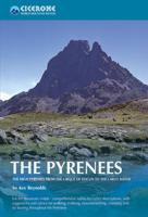
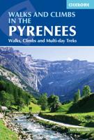
Wandelgids The Pyrenees - Pyreneeen | Cicerone

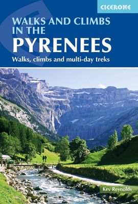
Uitputtende beschrijving van alle wandel- en klimmogelijkheden in de Pyreneeen. Ongekende diepgang in informatie over wat, waar en hoe de gebieden in elkaar zitten. Geschreven door een van de toonaangevende bergwandelaars op dit moment: Kev Reynolds. Essential guidebook of walks and climbs in the Pyrenees, one of Europe's finest mountain ranges. T...
24,95

Webshops met dit product

Webshop
Bezorging
Prijs

Anderen bekeken ook

Wandelgids The Pyrenees - Pyreneeen | Cicerone
Uitputtende beschrijving van alle wandel- en klimmogelijkheden in de Pyreneeen. Ongekende diepgang in informatie over wat, waar en hoe de gebieden in elkaar zitten. Geschreven door een van de toonaangevende bergwandelaars op dit moment: Kev Reynolds. Essential guidebook of walks and climbs in the Pyrenees, one of Europe's finest mountain ranges. The guide includes 170 day walks, multi-day walks, climbing routes and mountaineering ascents, and covers all valleys and peaks on both sides of the border with France and Spain, with through routes and peaks to bag.   The guidebook divides the range into 21 sections, including Andorra, the Ordesa National Park, the Carlit Massif, Gavarnie and the Cirque du Lescun to name a few. Each area includes practical information on travel, accommodation and mountain refuges, as well sketch mapping.   Between short, half-hour walks, to 12-day treks and 25 summits, this guidebook will help any walker, climber or trekker experience the best of the Pyre…
24,95
Wandelgids Shorter Treks in the Pyrenees | Cicerone
Uitstekende wandelgids van dit geweldige gebied. Goed beschreven met veel praktische informatie om de route te kunnen lopen, inclusief redelijke kaarten. A guidebook to seven circular treks exploring the Pyrenees of France and Spain. Seven 1 or 2 week routes in dramatic mountain scenery, including the Pic du Midi d'Ossau, Vignemale, Ordesa Canyon, Gavernie, Puigmal and Canigou. Using mostly waymarked mountain paths, with some boulderfield or easy scrambling, the treks are designed with accommodation in mountain refuges or mountain villages at the end of each stage, though there are plenty of options to camp for those who prefer to backpack. Detailed descriptions for each stage of the route are accompanied by sketch maps and elevation profiles, and there are notes on planning, equipment and access. The Pyrenees stretch 400km from Atlantic to Mediterranean, forming a barrier rising to over 3000m between France and Spain. The steep rolling hills of the Basque Country give way to the spe…
23,95
Wandelgids GR10 trail, Pyrenees - Pyreneeen | Cicerone
Engelstalige beschrijving van de mooiste wandeltocht in de Pyreneeen. De gids voldoet aan alle verwachtingen die je kunt hebben. Wel heb je voor de zwaardere gedeelte voor de zekerheid goede kaarten nodig ...... Guidebook to the GR10, a 955km trek across the French Pyrenees from Hendaye on the Atlantic Coast to the Mediterranean coast at Banyuls-sur-Mer. Described in 55-day stages, the route can be completed in its entirety, or in shorter sections using the bus and rail links found throughout the Pyrenees.   Step by step route descriptions are accompanied by 1:100,000 mapping and gradient profiles. Useful practical information is also included such as when to go, getting there and back, camping, accessing fuel and water, plus handy equipment tips and more.   The easiest, oldest and most popular of the three long-distance routes that traverse the mountain range, the GR10 is well waymarked and follows good mountain paths. For many walkers, the highlight of the route is the magnificent wi…
26,50
Wandelgids Karawanken - Slovenie - Walking in the Karavanke | Cicerone
Goede wandelgids met veel dagtochten; redelijk kaartmateriaal en goede praktische informatie. This guidebook offers 23 walking routes set across the magnificent 120km-long Karavanke mountain range, which forms a natural border between Austria and Slovenia. Commonly known as 'the way the Alps used to be', as it is yet to experience the extent of commercial development known by the Western Alps, it is one of the longest ranges in Western Europe but it remains genuinely unspoilt and relatively unvisited by English-speaking hillwalkers. The guide's walks begin in pretty towns and villages, and most of them access the peaks from the relatively more gentle Slovenian side of the range, where forest-clad slopes lead to grassy summits where spectacular views can be enjoyed. Arranged by peak from west to east along the range, most of the summits can be reached by waymarked paths and trails. The guide gives all the practical details you need on transport, accessing the routes, accommodation and a…
20,95
Wandelgids Walking in Italy's Stelvio National Park | Cicerone
Wandelgids voor de Stelvio Nationaal Park in de Rätische Alpen ( Alpi Retiche ) ten zuiden van de Splügenpas op de grens met het Zwitserse Graubünden. Engelstalige beschrijving van 38 dagwandelingen.   Aanbevolen wandelkaarten 1:25.000 voor deze gids Wandelkaart 008 Ortles - Cevedale - Ortlergebiet | Tabacco Editrice   Wandelkaart 045 Latsch - Martell - Schlanders- Laces - Val Martello - Silandro | Tabacco Editrice   Wandelkaart 048 Val di Peio - Val di Rabbi - Val di Sole | Tabacco Editrice   The wide range of 38 summer day walks in this guide explore the renowned Stelvio National Park in the Italian Rhaetian Alps. Bordering the Dolomites to the east, and Switzerland to the west, the Stelvio is one of the largest protected areas in all of the Alps. Its unspoilt landscape ranges from valley farmland to forested hillsides and alpine meadows, and up to a wilderness of rugged glaciated summits and ridges, the highest of which is Ortler, at 3905m.   The walks, a selection of routes from ea…
20,95
Wandelgids Walking and trekking in the Sierra Nevada | Cicerone
Uitstekende wandelgids voor de Sierra Nevada. Goed beschreven met veel praktische informatie om de route te kunnen lopen, inclusief redelijke kaarten. Aanbevolen wandelkaarten Wandelkaart NP Sierra Nevada met Alpujarras | Editorial Penibetica 1:40.000 of Wandelkaart Sierra Nevada en Alpujarras | Editorial Alpina - 1:40.000 Wandelkaart Sierra Nevada - la integral de los 3000 | Editorial Piolet 1:25.000   This guidebook presents 33 graded walks and 5 high mountain scrambles in the striking Sierra Nevada, the highest mountain range in mainland Spain and in western Europe outside the Alps. Easily accessible from Granada and Málaga, it is a world of soaring, snow-clad peaks and deep valleys, far removed from the crowded beaches of the Costa del Sol just two hours away. The routes are spread across the national park, with attractive towns and villages such as Trevélez, Lanjarón, Hoya de la Mora and Cumbres Verdes serving as potential bases for a walking holiday.   The walks have been careful…
20,95

Klanten-reviews van Wandelgids The Pyrenees - Pyreneeen | Cicerone

Er zijn nog geen beoordelingen voor dit productBen jij de eerste die een review plaatst?

Meer over Wandelgids The Pyrenees - Pyreneeen | Cicerone

Productomschrijving

Uitputtende beschrijving van alle wandel- en klimmogelijkheden in de Pyreneeen. Ongekende diepgang in informatie over wat, waar en hoe de gebieden in elkaar zitten. Geschreven door een van de toonaangevende bergwandelaars op dit moment: Kev Reynolds. Essential guidebook of walks and climbs in the Pyrenees, one of Europe's finest mountain ranges. The guide includes 170 day walks, multi-day walks, climbing routes and mountaineering ascents, and covers all valleys and peaks on both sides of the border with France and Spain, with through routes and peaks to bag.   The guidebook divides the range into 21 sections, including Andorra, the Ordesa National Park, the Carlit Massif, Gavarnie and the Cirque du Lescun to name a few. Each area includes practical information on travel, accommodation and mountain refuges, as well sketch mapping.   Between short, half-hour walks, to 12-day treks and 25 summits, this guidebook will help any walker, climber or trekker experience the best of the Pyrenees. There are exquisite valleys and passes to wander and summits of 3000m and more within the reach of most hill walkers. The landscape is full of diversity and contrast, with Alpine-style peaks, small glaciers, deep gorges and more than 1000 mountain lakes. Steden en Dorpen Etsaut, Borce, Lescun, Laruns, Gabas, Eaux-Bonnes, Gourette, Arrens, Lac d'Estaing, Cauterets, Gavarnie, Torla, Bielsa, Gèdre, Héas, Barèges, St-Lary, Benasque, Eriste, Arties, Salardu, Bohi, Espot, Capdella, Àreu, Vicdessos, Andorra, Ax-les-Thermes, Porté-Putmorens

Productspecificaties

Artikelnummer(s)
Brand
Cicerone
Webshop.nl maakt gebruik van cookies. Ga je verder op onze website, ga dan akkoord met het plaatsen van cookies en de verwerking van deze data door ons en vermelde partners.