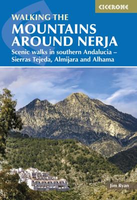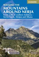
Wandelgids The Mountains Around Nerja | Cicerone

0
Uitstekende wandelgids van een gerenommeerde Engelse uitgever. De tochten zijn met zorg beschreven en voorzien van allerhande nuttige informatie. Aanbevolen wandelkaarten A guidebook to 32 day walks in and around the coastal town of Nerja, Spain. Exploring the mountains, gorges and white mountain villages of the Sierras Tejeda and Almijara and Alh...

Verkopers met dit product

Verkoper
Bezorging
Prijs
DeZwerver.nl logo
DeZwerver.nl
2,95
24,95

Anderen bekeken ook

Wandelgids Walk! Costa del Sol: Axarquia | Discovery Walking Guides
Goede wandelgids van een uitermate geschikt wandelgebied aan de Costa del Sol: het binnenland boven Nerja rond Competa en andere bergdorpen. De beschrijvingen zijn prima, zo ook de praktische informatie en de kaarten. We celebrate a Costa del Sol that does not correspond to the cliches, a Costa del Sol that is all right rather than all wrong, a playground of green valleys and gilded mountain tops, a hidden idyll unknown to most visitors, a haven for dedicated walkers and adventurous tourists alike, a place in which every nook is graced with some gratifying discovery and every outing is a great adventure. The majority of walks are aimed at the adventurous leisure walker, people who will on the whole have some experience of hiking in mountains, are happy to invest a certain amount of effort for a corresponding reward. Covering the best preserved stretch of coastline, the prettiest villages, and most spectacular mountains, Walk! Costa del Sol explores the Axarquia region east of Malaga, …
18,50
Wandelkaart Parque Natural Sierras de Tejeda, Almijara y Alhama | Editorial Piolet
Een prachtige kaartenset op heel gedetaileerd nivo van de Sierra de Tejeda, opgedeeld in een west en oost gedeelte. Het nationale park igt ten noorden van Nerja, tussen Malaga en Motril.  Alle noodzakelijke details staan er op die je nodig hebt voor het wandelen. Hoogtelijnen, schaduwwerking in de kleuren, ingetekende wandelpaden en routesuggesties. Met name in nationale parken en daarom heen in zuidelijk Europa is een geode kaart best handig: er zijn veel ezel- en geitenpaadjes die voor verwarring zorgen.  Van de uitgever Topographic map of the whole 'Natural Park of Sierras de Tejeda, Almijara and Alhama', more than 40,000 hectares of protected area with an impressive natural wealth. The peaks, some over 2,000 m high, are a natural border between the provinces of Granada and Malaga. The rugged and rugged landscapes make this area an ideal place for hiking enthusiasts of all levels. From a cultural point of view, Muslim heritage is present throughout the territory, with whitewashed v…
19,95
Wandelgids The Mountains of Romania - Roemenië | Cicerone
Guidebook to walks and multi-day treks in the Carpathian mountains of Romania. Includes routes in the Maramures and Bucovina regions, Piatra Craiului ridge, and the Retezat and Fagaras mountains. This guide describes 27 short treks of 2-6 days and 10 day walks in the mountains of Romania. Although there is a slight focus on Transylvania, most of the main massifs are included, with chapters covering the Mountains of Maramures, the Eastern Carpathians, the mountains around Brasov, the Fagara?, the region between the Olt and the Jiu, the Retezat, the mountains of Banat and the Apuseni. Also included is an ascent of Moldoveanu, Romania's highest peak at 2544m.   There is a wealth of advice to help you plan your trip and organise the logistics of your walk or trek. Some routes avail of the network of mountain huts; others offer opportunities to camp in attractive wild locations. Overviews and a route summary table make it easy to choose an appropriate excursion. Each route includes clear d…
26,50
Wandelgids The high mountains of Crete - Kreta | Cicerone
Guidebook to walking and trekking the high mountains of Crete. The largest of the Greek Islands, Crete's mountains provide breathtaking walking and wilderness to this popular island. The routes in this guidebook are graded for difficulty and range from short, easy strolls to challenging, multi-day treks and summit climbs, so there are options for walkers of all abilities.    All the mountain ranges of Crete feature high plains, gorges and ravines, but in the heart of the Lefka Ori there is something else. High above the treeline snow thaws by July to reveal a great circle of massive barren peaks, interspersed with ‘moonscape’ outcrops, or depressions, of sinkholes in black, grey or red rock. This high desert wilderness is seldom visited but covers some 960sqkm.   In central Crete, where the island is at its widest, the huge mass of Psiloritis (Mount Ida) dominates the whole region. Covering about 560sqkm this massif is different in that a single huge, partly scree-surfaced summit ridg…
26,50
Wandelgids The Mountains of Montenegro | Cicerone
Bijzondere wandelgids van een bijzonder land in opkomst: goed beschreven, met veel informatie en details, dus zeer bruikbaar! This guidebook includes a range of day-walks and multi-day treks throughout the Dinaric Alps of Montenegro. These mountains are some of the wildest, most spectacular, and least visited in Europe. Nevertheless they are easily accessible, and many areas have well-marked trails. They present an opportunity to travel through outstandingly beautiful and remarkably unspoilt natural scenery, which sees few visitors. The guide covers the most spectacular mountain areas in Montenegro, with a selection of circular and linear routes, with variants and extensions.   The guide also includes generous background information, including mountain huts and shelters, travel to and within the country, history and language, as well as what to expect in the various mountains and National Parks the routes explore. This is the first comprehensive English-language guide to walking in th…
25,95
Wandelgids Walking in the Thames Valley | Cicerone
Walking in the Thames Valley offers 25 challenging circular walks around the River Thames and River Kennet in the south of England, taking in the Southern Chilterns, the Berkshire and North Hampshire Downs, Southern Oxfordshire and the eastern edge of Wiltshire. All routes are within easy reach of Reading, Newbury, Abingdon and London. While some walks visit Iron Age hill forts, others pass more modern features such as Wilton Windmill and the Kennet and Avon Canal. Some follow sections of the Ridgeway, while others meander along the banks of the Thames. What they all have in common is that they take the keen rambler to some of the best parts of the Thames Valley – a patchwork of open chalk grassland, broadleaved woodland and farmland and home to two Areas of Outstanding Natural Beauty. • walks from 10 to 18 miles, including one 2-day route • shorter, less strenuous alternatives for many of the walks • detailed route descriptions with information on local points of interest, OS mapping…
18,50
Wandelgids The Hebrides - De Hebriden Schotland | Cicerone
This inspirational guide offers 50 varied hiking and backpacking routes on the Scottish Hebrides islands, set out in a large guidebook to be savoured. The hikes highlight all the very best landscapes and scenery to be found on the spectacular islands of the Hebrides, a wonderland for adventurous walkers to return to time and time again. Inspirational guidebook to walking in Scotland's Hebrides islands. 50 adventurous walks on well-known and remote islands; from Syke, Mull, Rum, the Uists and Barra, Ulva, Iona, Eigg and Muck and more besides. Most of the walks provide a full day for experienced walkers, with a few multi-day adventures as well as some shorter routes. The terrain is often rough, rugged and pathless, while waymarking and public transport can, in many places, be hard to find. The challenge of wild walking, and the self-reliance needed to discover the best of the Hebrides, make the islands all the more appealing for adventurous walkers.   The walks also include Hebrides cla…
28,50
Wandelgids 100 Hut Walks In The Alps | Cicerone
This guidebook has route descriptions for 100 day walks to suit alpine walkers of all abilities, with suggestions for some hut-to-hut tours. These routes take you through breathtaking scenery in the Maritime Alps, Julian Alps, Gran Paradiso, the Turnitzer Alps, Bernese Oberland, the Kitzbuheler Alps and the Dolomites of South Tirol. Extending in huge arc of more than 1000km (620 miles) from the Mediterranean coast near Nice to the low, wooded foothills outside Vienna, the Alps display the full gamut of mountain landscape features. All of the routes in this guide have been specially selected to show the amazing diversity of this wonderful mountain chain.   There are walks to suit every taste: gentle and undemanding, long and tough, and everything in between. Most of the routes avoid climbing of a technical nature except the odd scramble aided by a fixed rope. Glacier crossings where crevasses lurk for the unwary have also been avoided in the main, although just a small handful of walks…
22,95
Wandelgids Karawanken - Slovenie - Walking in the Karavanke | Cicerone
Goede wandelgids met veel dagtochten; redelijk kaartmateriaal en goede praktische informatie. This guidebook offers 23 walking routes set across the magnificent 120km-long Karavanke mountain range, which forms a natural border between Austria and Slovenia. Commonly known as 'the way the Alps used to be', as it is yet to experience the extent of commercial development known by the Western Alps, it is one of the longest ranges in Western Europe but it remains genuinely unspoilt and relatively unvisited by English-speaking hillwalkers. The guide's walks begin in pretty towns and villages, and most of them access the peaks from the relatively more gentle Slovenian side of the range, where forest-clad slopes lead to grassy summits where spectacular views can be enjoyed. Arranged by peak from west to east along the range, most of the summits can be reached by waymarked paths and trails. The guide gives all the practical details you need on transport, accessing the routes, accommodation and …
20,95
Wandelgids Walking on Arran | Cicerone
Uitstekende wandelgids voor dit uitdagende wandelgebied in Schotland. Dagtochten. The 45 walking routes in this Isle of Arran guidebook range from easy 3km (2 miles) nature trails to long arduous mountain routes with scrambles (up to 32km) providing thorough coverage of Arran, including the ascent of Goatfell and nearby Holy Isle. Most routes are 10km to 15km long but many give opportunities to create longer cross island walks. This guidebook presents a selection of 45 day walks on the popular and accessible Isle of Arran. The routes are between 2 miles (3km) and 20 miles (32km) in length, from easy waymarked forest trails to more arduous mountain walks, exposed ridge routes and scrambles. There are linear and circular walks to choose from, and opportunities to link routes together and create longer walks across the length and breadth of the island. With highlights including Goatfell, Beinn Tarsuinn, the Sannox Horseshoe, Glen Rosa and the Cock of Arran, there's something here to suit…
23,95

Klanten-reviews van Wandelgids The Mountains Around Nerja | Cicerone

Er zijn nog geen beoordelingen voor dit productBen jij de eerste die een review plaatst?

Meer over Wandelgids The Mountains Around Nerja | Cicerone

Productomschrijving

Uitstekende wandelgids van een gerenommeerde Engelse uitgever. De tochten zijn met zorg beschreven en voorzien van allerhande nuttige informatie.

Aanbevolen wandelkaarten

A guidebook to 32 day walks in and around the coastal town of Nerja, Spain. Exploring the mountains, gorges and white mountain villages of the Sierras Tejeda and Almijara and Alhama Natural Park in southern Andalucia, there are routes for walkers of all levels of fitness and experience.   The walks are graded by difficulty and range from 3–22km (2–14 miles) in length, covering 110–1420m of ascent and taking between 1hr 30min and 7hr 30min to complete.   Clear description of the route alongside 1:50,000 or 1:25,000 maps Highlights include ascents of La Maroma, Cisne and Navachica Packed with information on local history, geology and wildlife Each walk features detailed instructions on getting to the start, plus where to find refreshments and water sources Some routes visit sections of the 700km (430 mile) Gran Senda de Malaga (Great Path of Malaga) Easy access from Nerja, Velez-Malaga and Cómpeta GPX files available to download

Verken gerelateerde categorieën

Webshop.nl maakt gebruik van cookies. Ga je verder op onze website, ga dan akkoord met het plaatsen van cookies en de verwerking van deze data door ons en vermelde partners.