webshop.nl
Categorieën
  Sluiten

Meer Rucksack Readers
Meer Rucksack Readers in Literatuur boeken

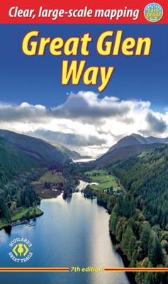
Wandelgids The Great Glen Way | Rucksack Readers

0
Uitgevoerd in de vorm van een klapper, met ringband geeft deze gids een goede beschrijving van de lange afstands route. De kaarten zijn schetsmatig maar wel duidelijk. The Great Glen Way is one of Scotland’s Great Trails and offers a superb experience for both walkers and cyclists. The Way runs for 77 miles (124 km) along Scotland’s Great Glen betw...

Webshops met dit product

Webshop
Bezorging
Prijs

Anderen bekeken ook

Wandelgids The Great Glen Way | Cicerone
Uitstekende wandelgids van de Great Glen Way, waarbij naast alle noodzakelijke informatie ook gebruik gemaakt wordt van de echte topografische kaart. inclusief gidsje met routekaarten van 1:25000 (deze is hier ook los te bestellen)   Guidebook to walking the Great Glen Way, one of Scotland’s Great Trails that runs along the Great Glen between Fort William and Inverness. The guidebook - which includes both a guide to the route and a separate OS map booklet – describes the route in both directions.   Ideal as an introduction to long-distance walking, the 79-mile Great Glen Way is split into six stages easily walked within a week, with high- and low-level options given for two of these. An alternative route past the northern side of Loch Oich (via Invergarry) is also described.   The guidebook includes practical information, 1:100,000 OS mapping, step-by-step route descriptions for every stage of the walk and lists the facilities found along the way. A separate booklet of 1:25,000 OS mapp…
22,50
Wandelgids Great Glen Way | Trailblazer Guides
Goede wandelgids waarin met veel details alle etappes zijn beschreven. Tevens informatie over overnachtingen en openbaar vervoer. All-in-one, practical guide to walking the Great Glen Way long-distance footpath. The trail begins where the West Highland Way ends - at Fort William - and follows the Great Glen faultline to finish at Inverness after 79 miles (127km). The trail passes Loch Lochy, Loch Oich and Loch Ness and also follows the towpath of the Caledonian Canal.   It's a relatively easy week-long walk amongst beautiful Highland scenery but there's a high level option between Fort Augustus and Drumnadrochit that gives even better mountain views. This 2nd edition has been re-walked and fully updated. * Includes 38 detailed walking maps: the largest-scale maps available - at just under 1:20,000 (8cm or 31/8 inches to 1 mile) these are bigger than even the most detailed walking maps currently available in the shops * Unique mapping features - walking times, directions, tricky junctio…
19,95
Wandelatlas The Great Glen Way | Cicerone
Handzaam gidsje met alleen de topografische routekaarten van 1:25000. De uitgebreide wandelgids (inclusief dit gidsje) is hier te bestellen. This booklet of Ordnance Survey 1:25,000 Explorer maps has been designed for convenient use on the trail. It shows the full and up-to-date line of the Way, along with the relevant extract from the OS Explorer map legend. It is conveniently sized for slipping into a jacket pocket or top of a rucksack and comes in a clear PVC sleeve.   The companion guidebook – The Great Glen Way – describes the full route in both directions with lots of other practical and historical information. NOTE: The accompanying guidebook includes a copy of this map booklet.   The Great Glen Way is one of Scotland's Great Trails and follows the course of the Caledonian Canal through the Highlands from Fort William to Inverness over up to 79 miles (124km). The waymarked trail includes easy, level stretches, undulating forest tracks, lakeside paths and old drove and military r…
11,95
Wandelgids The Speyside Way | Rucksack Readers
Deze gids een goede beschrijving van de lange afstands route. De kaarten zijn schetsmatig maar wel duidelijk. The Speyside Way is one of Scotland’s Great Trails. It runs for 80 miles (128 km) from the fishing port of Buckie to Aviemore in the foothills of the Cairngorms. Following the lovely valley of the River Spey, you walk through countryside rich in malt whisky and wildlife, along riverside paths, railway trackbed and forest and moorland tracks.   The second edition was fully revised, with mapping from Footprint in six panels, updated plans of villages along the Way, including a fresh Grantown plan and directions from the terminus in Buckie. In 2016 we released the revised version of this essential trail guide, with fresh photos, new mapping and many other updates. These included documenting the 6.5-mile route extension to Kincraig, which opened in 2015, and 11-mile Badenoch Way.   This guidebook contains all you need to plan and enjoy the Speyside Way:   the Way step-by-step, …
22,50
Wandelgids The Rob Roy Way | Rucksack Readers
Deze gids geeft een goede beschrijving van de lange afstands route. De kaarten zijn schetsmatig maar wel duidelijk. The Rob Roy Way is one of Scotland's Great Trails and is very popular with both walkers and cyclists. It runs through many places linked with Scotland's most famous outlaw, Rob Roy MacGregor (1671-1734). The route starts at Drymen (near Glasgow) and ends at Pitlochry in the eastern Highlands, so it takes you away from the crowds following the West Highland Way to some of Scotland's finest lochs and glens.   Its main spine runs for 79 miles (127 km) and is waymarked. There is an optional extra 17 miles if you take the wilderness extension through Glen Almond and Glen Quaich. Most walkers complete it in 6-8 days and most cyclists in 3-4 days.   The main route goes through Loch Ard forest to Aberfoyle, goes beside Lochs Venachar, Lubnaig and Tay and passes through superb scenery, with interesting aqueducts, viaducts and a 3600 year-old stone circle. The terrain is a mix…
22,50
Wandelgids Loch Lomond & Cowal Way | Rucksack Readers
"Lavishly illustrated guidebook with route map plus practical information" - Scots Magazine The Loch Lomond & Cowal Way is one of Scotland's Great Trails. It runs for 57 miles (91 km) across the Cowal peninsula, which lies west of Glasgow and is easily reached by public transport, road and ferry. The route starts at Portavadie on Loch Fyne and ends at Inveruglas on Loch Lomond. The trail is waymarked and undulating, with rugged terrain and glorious views over the Isle of Bute and the Firth of Clyde. The area is rich in history and heritage, with wildlife sightings including red squirrel, red deer and golden eagle. Cowal has ferries to Bute, to Kintyre and (in season) across Loch Lomond to join the West Highland Way. It’s the missing link that enables Scotland’s ultimate long-distance walk, from Kintyre all the way to Inverness. In 2018 the route’s name was extended to "Loch Lomond & Cowal Way" to reflect the fact that over 50% of it runs within the Loch Lomond & Trossachs National Park…
19,95

Klanten-reviews van Wandelgids The Great Glen Way | Rucksack Readers

Er zijn nog geen beoordelingen voor dit productBen jij de eerste die een review plaatst?

Meer over Wandelgids The Great Glen Way | Rucksack Readers

Productomschrijving

Uitgevoerd in de vorm van een klapper, met ringband geeft deze gids een goede beschrijving van de lange afstands route. De kaarten zijn schetsmatig maar wel duidelijk. The Great Glen Way is one of Scotland’s Great Trails and offers a superb experience for both walkers and cyclists. The Way runs for 77 miles (124 km) along Scotland’s Great Glen between Fort William and Inverness. It follows the scenic Caledonian Canal and runs beside four of the Highlands’ loveliest lochs – including Loch Ness, famous for its monster legend and for Urquhart Castle.   This new edition of our popular guidebook has been fully revised in 2019-20 after extensive fieldwork. It includes new large-scale mapping (1:38,000) with mileage markers and a kilometre grid, many updates and fresh photos, and is in our slim pocket-friendly format, still on rainproof paper.   This guidebook contains all you need to plan and enjoy the Great Glen Way – on foot or on a bike:   detailed mapping on 13 pages at 1:38,000 hill and mountain side-trips including Ben Nevis background on canal heritage, clan history and wildlife detailed description for each section walked from Fort William to Inverness summaries showing distance, terrain, food/drink stops and altitude profile planning information for walkers and cyclists town plans of Fort William and Inverness in full colour, with 100+ photos, many of them new rucksack-friendly and on rainproof paper.

Productspecificaties

Artikelnummer(s)
Brand
Rucksack Readers

Verken gerelateerde categorieën

Webshop.nl maakt gebruik van cookies. Ga je verder op onze website, ga dan akkoord met het plaatsen van cookies en de verwerking van deze data door ons en vermelde partners.