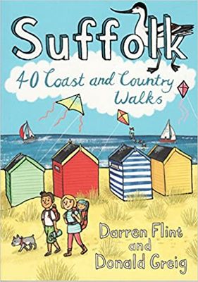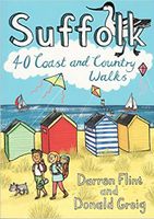
Wandelgids Suffolk : 40 Coast and Country Walks | Pocket Mountains

0
Handige compacte wandelgids met 40 dagwandelingen. Deze gids bevat kleine kaartjes en leuke uitgebreide informatie over wat er langs de route te zien is. Goede wandelkaarten zijn echter we noodzakelijk voor deze tochten: de Ordnance Survey explorer maps of Landanger maps zijn zeer geschikt.     Suffolk has long been a place of retreat, somewhere...

Verkopers met dit product

Webshop
Bezorging
Prijs
DeZwerver.nl logo
DeZwerver.nl
niet bekend
10,95

Anderen bekeken ook

Fietskaart 14 Cycling guides Suffolk | Goldeneye
To be confronted with the variety and complexity of the cycling routes, trails and paths in Suffolk can be a bewildering experience.  For it appears that the Suffolk County Council and the three District Councils are all trying hard to promote their areas. This is indeed encouraging for the growth of cycling, but it can be confusing.  Our purpose is to provide clear, easy to use and easy to follow, cycling maps, and to illustrate these in a comprehensive form.    Suffolk must be one of the most charming of counties to explore by bicycle. When Al Churcher delivered his routes to us at Goldeneye we couldn’t keep him quiet, such was his enthusiasm and wonder at Suffolk’s country lanes and byways. He has cycled all over the UK, Canada, Mallorca, New Zealand and Sicily, but Suffolk remained a firm favourite.    The inland scenery is not spectacular for the county’s main glory lies with its attractive villages; the local architecture jealously preserved from modern depredation. There is an …
15,95
Wandelgids Pembrokeshire : 40 Coast and Country Walks | Pocket Mountains
Handige compacte wandelgids met 40 dagwandelingen. Deze gids bevat kleine kaartjes en leuke uitgebreide informatie over wat er langs de route te zien is. Goede wandelkaarten zijn echter we noodzakelijk voor deze tochten: de Ordnance Survey explorer maps of Landanger maps zijn zeer geschikt.     As the home of Britain's one and only national coastal park, Pembrokeshire is rightly famed for its marine wildlife, unspoilt beaches, towering cliffs and charming harbours. Inland, however, you will also find ancient woodlands and rolling hills, as well as archaeological mysteries and crumbling castles which suggest that this peaceful part of Wales has a far more turbulent past.The 40 moderate walks in this volume from award winning publisher Pocket Mountains, explore the stunning coastline as well as the heartland of the county, with several routes making use of sections of established long-distance walking trails.  
10,95
Wandelgids Orkney | Pocket Mountains
Handige compacte wandelgids met 40 dagwandelingen. Deze gids bevat kleine kaartjes en leuke uitgebreide informatie over wat er langs de route te zien is. Goede wandelkaarten zijn echter we noodzakelijk voor deze tochten: de Ordnance Survey explorer maps of Landanger maps zijn zeer geschikt.   The 40 walks in this guide range from a short stroll to hikes of several hours, but most can be completed in half a day or less. The majority are circular, several are lollipop-shaped and some require you to return by the same route. They all, however, end up back where they started, so you will not find yourself miles from your car. Each route is prefaced by an indication of the distance involved and the time it is likely to take. The latter is estimated on the time it took the author to walk the route (averaging around 3.5km per hour) before adding a little for tea, toilet and tourism stops. The timings should be regarded as a rough guide, and if you have to catch a bus or boat at the end of th…
10,95
Wandelgids Norfolk Coast Path - Peddars Way | Trailblazer Guides
The Norfolk Coast Path & Peddars Way cover 130-miles of walking trails. The Peddars Way runs through East Anglia from Knettishall Heath on the Norfolk/Suffolk border and follows a Roman road to Holme-next-the-Sea. From here it becomes the Norfolk Coast Path, hugging the beautiful Norfolk coastline through Holkham, Wells, Blakeney and Cley to Cromer before it rounds the shoulder of the county and continues along the superb beaches and crumbling cliffs to Mundesley, Sea Palling and Great Yarmouth, finishing just before the Suffolk border.   Includes: 77 large-scale walking maps - at just under 1: 20,000 (8cm or 3 and one eighth inches to 1 mile) our maps are bigger than even the most detailed walking maps currently available, with walking directions, tricky junctions, places to stay and eat, points of interest and walking times written onto the maps Text and maps in clear TWO-COLOUR style All standards of accommodation with reviews - campsites, B&Bs, hostels, hotels, bunkhouses Where to…
20,95
Reisboek - Wandelgids Wild Swimming Walks Peak District | Wild Things Publishing
The best-selling Wild Swimming Walks series returns with adventures in Britain's oldest National Park. Ascend to the highest tarns and descend through a valley of secret waterfalls * Walk through woodland gorges carved by cascades * Follow bucolic river valleys dipping as you walk. Wild Swimming Walks Peak Disitrict leads you on 28 adventures in the soaring landscape of the Peak District. Find secret waterfalls, remote lakes and sparkling river pools. Complete with photos, maps and practical guidance, rich in local history and stories, this book will appeal to wild swimmers, family explorers, nature lovers and walkers alike.   JOIN THE ADVENTURE with the best-selling Wild Swimming Walks series and explore Britain’s oldest national park from the gritstone edges of the Hope Valley, to the magical streams on the moorlands of Bleaklow, through to the picturesque limestone river dales of the White Peak.   Scramble up streams and waterfalls at Black Clough Explore fairy pools and mossy…
20,95
Wandelgids Shetland | Pocket Mountains
Handige compacte wandelgids met 40 dagwandelingen. Deze gids bevat kleine kaartjes en leuke uitgebreide informatie over wat er langs de route te zien is. Goede wandelkaarten zijn echter we noodzakelijk voor deze tochten: de Ordnance Survey explorer maps of Landanger maps zijn zeer geschikt. The most northerly of Britain's island groups, Shetland is so far removed from the rest of the UK that it usually appears as an inset on maps. Although relatively little known to those from outside the islands, Shetland is a magnificent terrain for walkers, especially those who love to really explore and get away from the beaten track. The coastal walking here includes some of the finest in the country, with superb cliffs, towering sea stacks, caves and natural arches seemingly around every corner. Added to this is Shetland's better known claim to fame for its spectacular seabird colonies, huge gannetries, moorland packed with arctic and great skuas, arctic terns in the more sheltered spots, and ev…
10,95
Reisgids Walks in and around London | Rough Guides
This practical travel guide to Walks in and Around London features detailed factual travel tips and points-of-interest structured lists of all iconic must-see sights as well as some off-the-beaten-track treasures. Our itinerary suggestions and expert author picks of things to see and do will make it a perfect companion, both ahead of your trip and on the ground. This Walks in and Around London guide book is packed full of details on how to get there and around, pre-departure information and top time-saving tips, including a visual list of things not to miss.   Our colour-coded maps make Walks in and Around London easier to navigate while you're there. This guide book to London contains 46 walks in this new edition and 5 of them are completely new walks. It has been fully updated post-COVID-19 and comes with a free eBook.   The Rough Guide to Walks in and Around London covers: London, The North Downs, The Weald, The South Downs, The Saxon Shore, The North Wessex Downs to the New Forest…
22,50
Wandelgids The Tay | Pocket Mountains
Handige compacte wandelgids met 40 dagwandelingen. Deze gids bevat kleine kaartjes en leuke uitgebreide informatie over wat er langs de route te zien is. Goede wandelkaarten zijn echter we noodzakelijk voor deze tochten: de Ordnance Survey explorer maps of Landanger maps zijn zeer geschikt.     As well as being Scotland's longest river, the Tay also carries the largest volume of water of any river in the UK more than the Thames and Severn combined when it reaches the Firth of Tay. From its source high up the slopes of Ben Lui near Tyndrum, the Tay makes its way through Stirlingshire and Perthshire to meet the North Sea near Dundee. As one of the best salmon rivers in Europe, every year it lures anglers from around the world and countless more come to explore the glorious hills and glens it passes.   There is no better way to discover the wildlife, architecture and history of this area of Scotland than to walk. Whatever your ability walking at high or low level, following tough terra…
10,95
Reisgids Tahoe and Reno | Moon Travel Guides
De Amerikaanse uitgever Moon is een vergelijkbare gids met uitgever Lonely Planet > veel praktische informatie met veel diepgang! Het feit dat het een Amerikaanse uitgever is, maken deze gidsen zeer aantrekkelijk voor de staten afzonderlijk. De Lonely Planet haalt dat nivo niet! From the glittering lake and trail-lined mountains to Old West towns and artsy urban centers, experience the best of this adventurous region with Moon Tahoe & Reno. Inside you'll find:*Flexible itineraries, including a week-long Lake Tahoe road trip, long weekends for both winter and summer, and the one-week best of Tahoe and Reno*Strategic advice for hikers, skiers, beach bums, families with kids, foodies and brewery lovers, and more*The best hikes in Tahoe: Find your adventure, from challenging mountain treks to serene meadow walks, with trail descriptions, difficulty ratings, and detailed trail maps*Outdoor adventures for any season: Hit the slopes and get the first tracks through snow-covered pines or spar…
19,95
Wandelgids Thames Path | Trailblazer Guides
This book follows the Thames Path National Trail from the river's source in Gloucestershire to the Thames Barrier in London. Officially 184 miles (294km) in length (although the actual distance you walk will depend on a number of decisions you make en route), the path meanders, accompanied by its watery muse, through pristine and tranquil countryside, past historic sites and buildings, via pub, lock, weir, and the occasional scattering of waterfowl, to a city, once the fulcrum of an empire, and now the heart of modern day England. The river, responsible for the metropolis' very being, tells tales, inspires artists, accommodates swans, geese, and water voles, reflects the silhouettes of red kites and kingfishers, provides employment, entices adventure, and allows time for carefree pilgrims to procrastinate and think. Following its banks is a grand way to go for a ramble. The path begins, as the river does, in a meadow in the Cotswolds; its upper reaches lonely and wild, the meadows and…
19,95

Klanten-reviews van Wandelgids Suffolk : 40 Coast and Country Walks | Pocket Mountains

Er zijn nog geen beoordelingen voor dit productBen jij de eerste die een review plaatst?

Meer over Wandelgids Suffolk : 40 Coast and Country Walks | Pocket Mountains

Productomschrijving

Handige compacte wandelgids met 40 dagwandelingen. Deze gids bevat kleine kaartjes en leuke uitgebreide informatie over wat er langs de route te zien is. Goede wandelkaarten zijn echter we noodzakelijk voor deze tochten: de Ordnance Survey explorer maps of Landanger maps zijn zeer geschikt.     Suffolk has long been a place of retreat, somewhere to escape to, far from everyday life. It may have its busier town centres, but in the main Suffolk remains a rural area of enormous variety , from heather covered heathland to softly rolling hills, long shingle spits to genteel coastal enclaves and kiss-me-quick seaside resorts. Whether you are looking for a morning hike or an afternoon stroll, Darren Flint and Donald Grieg's hand picked selection of 40 walks is guaranteed to fit the bill - or the boot.   Suffolk boasts 5,600km of public rights of way; take your pick, put your best foot forward and discover this most gentle of English counties.

Verken gerelateerde categorieën

Webshop.nl maakt gebruik van cookies. Ga je verder op onze website, ga dan akkoord met het plaatsen van cookies en de verwerking van deze data door ons en vermelde partners.