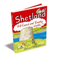
Wandelgids Shetland | Pocket Mountains

0
Handige compacte wandelgids met 40 dagwandelingen. Deze gids bevat kleine kaartjes en leuke uitgebreide informatie over wat er langs de route te zien is. Goede wandelkaarten zijn echter we noodzakelijk voor deze tochten: de Ordnance Survey explorer maps of Landanger maps zijn zeer geschikt. The most northerly of Britain's island groups, Shetland i...

Verkopers met dit product

Webshop
Bezorging
Prijs
DeZwerver.nl logo
DeZwerver.nl
niet bekend
10,95

Anderen bekeken ook

Wandelgids Loch Ness, Inverness, Black Isle and Affric | Pocket Mountains
Handige compacte wandelgids met 40 dagwandelingen. Deze gids bevat kleine kaartjes en leuke uitgebreide informatie over wat er langs de route te zien is. Goede wandelkaarten zijn echter we noodzakelijk voor deze tochten: de Ordnance Survey explorer maps of Landanger maps zijn zeer geschikt.   A guide to 40 favourite walks around Loch Ness, Inverness, Black Isle and Glen Affric. Loch Ness, with its legendary monster, is the most famous of all lochs. It holds more water than all the lakes of England and Wales combined and the countryside around it features an equally great variety of walks, with more waymarked trails and easy routes suitable for families than many other parts of the Highlands. Further north lies the magnificent Glen Affric - Scotland's most beautiful glen.   This is a wonderful area of the Highlands for walkers, having the highest mountains north of the Great Glen but also some splendid lower-level and forest walks. To the east is the fertile Black Isle, packed with cha…
10,95
Wandelgids Dorset | Pocket Mountains
Handige compacte wandelgids met 40 dagwandelingen. Deze gids bevat kleine kaartjes en leuke uitgebreide informatie over wat er langs de route te zien is. Goede wandelkaarten zijn echter wel aan te raden voor deze tochten: de Ordnance Survey explorer maps of Landranger maps zijn zeer geschikt. From Old Harry Rocks, Lulworth Cove and Durdle Door, all along the shore of the Jurassic Coast to Lyme Regis, via the glowing summit of Golden Cap and the one-eyed winking lighthouse at Portland Bill, Dorset is a walkers’ wonderland.   The 40 routes in this book roam over hills and across heathland, go through forests and voluptuous valleys, trace ridgelines and precipitous cliffs, passing caves, castles, coves, country pubs and stunning viewpoints, to find vibrant villages and secret beaches. Here you’ll come face-to-face with history, walk with the words of Thomas Hardy ringing in your ears, witness wondrous wildlife and encounter all manner of cottage industries, from community cake- and marma…
10,95
Wandelgids The Cotswolds | Pocket Mountains
Handige compacte wandelgids met 40 dagwandelingen. Deze gids bevat kleine kaartjes en leuke uitgebreide informatie over wat er langs de route te zien is. Goede wandelkaarten zijn echter we noodzakelijk voor deze tochten: de Ordnance Survey explorer maps of Landanger maps zijn zeer geschikt.   From upland outlooks and secret valleys to rolling pastures and honey stone villages, nature and history weave together in the Cotswolds to create a landscape that is the epitome of rural England. In these 40 walks Dominic North unlocks the secrets of the Cotswolds, from the hills and lanes in the north to the languid riverbanks and ancient woods of the south. Along the way discover sleepy villages, grand country houses and architectural curiosities, and then reach out to explore three of England's most celebrated cities, Bath, Oxford and Stratford-upon-Avon. Plaatsen in het boekje Bath, Bathampton, Batsford, Belas Knap, Bibury, Blenheim Park, Blockley, Bourton-on-the-Hill, Bourton-on-the-Water, …
10,95
Wandelgids Somerset | Pocket Mountains
Handige compacte wandelgids met 40 dagwandelingen. Deze gids bevat kleine kaartjes en leuke uitgebreide informatie over wat er langs de route te zien is. Goede wandelkaarten zijn echter wel aan te raden voor deze tochten: de Ordnance Survey explorer maps of Landranger maps zijn zeer geschikt. From the crumbly rhubarb-and-cream-coloured cliffs of the Jurassic Coast in the southeast to the surf-stroked craggy coves in the north, across the wilderness and woodland of Dartmoor and Exmoor, and through the verdant valleys and great green grazing lands of the dairy belt – Devon is a country of exquisite contrasts and natural wonder.   Whether you’re looking for an easy afternoon stroll along the shore, a riverside ramble to an atmospheric country pub or a tor-topping trek on the moors, there’s something to suit every boot in Patrick Kinsella’s inspiring collection of 40 Devon walks.   Plaatsen in het boekje Aisholt, Barle, River, Bath, Bathwick Hill, Bats Castle, Bishop’s Palace, Blagdon Hil…
10,95
Wandelgids Devon | Pocket Mountains
Handige compacte wandelgids met 40 dagwandelingen. Deze gids bevat kleine kaartjes en leuke uitgebreide informatie over wat er langs de route te zien is. Goede wandelkaarten zijn echter wel aan te raden voor deze tochten: de Ordnance Survey explorer maps of Landranger maps zijn zeer geschikt. From the crumbly rhubarb-and-cream-coloured cliffs of the Jurassic Coast in the southeast to the surf-stroked craggy coves in the north, across the wilderness and woodland of Dartmoor and Exmoor, and through the verdant valleys and great green grazing lands of the dairy belt - Devon is a county of exquisite contrasts and natural wonder. Whether you're looking for an easy afternoon stroll along the shore, a riverside ramble to an atmospheric country pub or a tor-topping trek on the moors, there's something to suit every boot in Patrick Kinsella's inspiring collection of 40 Devon coast and country walks. Plaatsen in het boekje Axminster, Baggy Point, Beer, Berry Camp, Bigbury-on-Sea, Bishop’s Walk,…
10,95
Wandelgids 100 outstanding British Walks | Ordnance Survey
Beschrijving van de 100 mooiste Pathfinder wandelingen in Engeland, Wales en Schotland. Uitstekende beschrijving van de route met een zeer duidelijke topografische kaart waarop de route is ingetekend.  This magnificent compendium of outstanding British walks brings together the finest selection of Pathfinder Walks in Britain s officially designated places of scenic beauty and historic interest: National Parks, Areas of Outstanding Natural Beauty, National Scenic Areas, Heritage Coast, National Trails and UNESCO World Heritage Sites. There are 100 walking gems in this collection, recommended by a group of experienced authors and guides. The walks span a range of distances and degrees of challenge and are organised by region with coverage across England, Wales and Scotland. 100 Outstanding British Walks is lavishly illustrated with stunning landscape photography and informative introductions to each of the walks. It is designed to be enjoyed at home, while the OS Maps app provides the p…
27,95
Reisgids Isle of Wight | Rough Guides
Een kleinere versie in zakformaat van de grotere versies van de Rough Guides. Als altijd weer vol met goede informatie over cultuur en praktische zaken. Achterin een kaart van de stad. This expert-curated guide book to Isle of Wight shines a spotlight on a more unusual British break, with a wealth of practical information on what to see and do. Each area or neighbourhood featured in this Isle of Wight travel guide is explored in-depth with detailed coverage of the points of interest, shops, restaurants, cafes and bars on offer. Excursions to surrounding areas give plenty of options for those looking to enjoy a longer stay. This Isle of Wight guide book has been fully updated post-COVID-19.   The Pocket Rough Guide to Isle of Wight covers: Cowes and around, Newport and around, Ryde and around, The east coast, The south coast, Ventnor to Blackgang, Brighstone to Alum Bay, Yarmouth and around.   Inside this travel guide to Isle of Wight you will find:   RECOMMENDATIONS FOR EVERY TYPE OF …
13,95
Wandelgids Caithness and Sutherland | Pocket Mountains
Handige compacte wandelgids met 40 dagwandelingen. Deze gids bevat kleine kaartjes en leuke uitgebreide informatie over wat er langs de route te zien is. Goede wandelkaarten zijn echter we noodzakelijk voor deze tochten: de Ordnance Survey explorer maps of Landanger maps zijn zeer geschikt. The county of Ayrshire is located on the Firth of Clyde on the beautiful West Coast of Scotland and is known as one of the most fertile areas of the country, famed for its cattle and crops. Although more industrial to the north, it is in the main a landscape made for walking with an abundance of open countryside and rugged little hills, golden sandy beaches and beautiful sunsets. This guide features 40 mostly moderate walks full of interest which explore all aspects of the region, from craggy cliffs and caves to historic castles, ancient forests to sandy shorelines. Sutherland and Caithness are the most northerly parts of mainland Britain. Northwest Sutherland is a landscape of sandy beaches and …
10,95
Wandelgids Ayrshire | Pocket Mountains
Handige compacte wandelgids met 40 dagwandelingen. Deze gids bevat kleine kaartjes en leuke uitgebreide informatie over wat er langs de route te zien is. Goede wandelkaarten zijn echter we noodzakelijk voor deze tochten: de Ordnance Survey explorer maps of Landanger maps zijn zeer geschikt.   The county of Ayrshire is located on the Firth of Clyde on the beautiful West Coast of Scotland and is known as one of the most fertile areas of the country, famed for its cattle and crops. Although more industrial to the north, it is in the main a landscape made for walking with an abundance of open countryside and rugged little hills, golden sandy beaches and beautiful sunsets. This guide features 40 mostly moderate walks full of interest which explore all aspects of the region, from craggy cliffs and caves to historic castles, ancient forests to sandy shorelines.
10,95
Wandelgids Outer Hebrides | Pocket Mountains
Handige compacte wandelgids met 40 dagwandelingen. Deze gids bevat kleine kaartjes en leuke uitgebreide informatie over wat er langs de route te zien is. Goede wandelkaarten zijn echter we noodzakelijk voor deze tochten: de Ordnance Survey explorer maps of Landanger maps zijn zeer geschikt. The Outer Hebrides are a place apart, an island chain stretching almost 200km from the Butt of Lewis to Barra Head with some of Britain's most mesmerising beaches, dramatic mountain ranges, wonderful wildlife, a long and fascinating history and a rich and vibrant Gaelic culture. This book features 40 mostly moderate walks, with many ideal for families, which take in magnificent sweeps of sand, soaring sea cliffs and memorable hill ascents, as well as celebrated cultural sights such as the haunting Standing Stones at Callanish and the blackhouse village of Na Gearrannan.
10,95

Klanten-reviews van Wandelgids Shetland | Pocket Mountains

Er zijn nog geen beoordelingen voor dit productBen jij de eerste die een review plaatst?

Meer over Wandelgids Shetland | Pocket Mountains

Productomschrijving

Handige compacte wandelgids met 40 dagwandelingen. Deze gids bevat kleine kaartjes en leuke uitgebreide informatie over wat er langs de route te zien is. Goede wandelkaarten zijn echter we noodzakelijk voor deze tochten: de Ordnance Survey explorer maps of Landanger maps zijn zeer geschikt.

The most northerly of Britain's island groups, Shetland is so far removed from the rest of the UK that it usually appears as an inset on maps. Although relatively little known to those from outside the islands, Shetland is a magnificent terrain for walkers, especially those who love to really explore and get away from the beaten track. The coastal walking here includes some of the finest in the country, with superb cliffs, towering sea stacks, caves and natural arches seemingly around every corner.

Added to this is Shetland's better known claim to fame for its spectacular seabird colonies, huge gannetries, moorland packed with arctic and great skuas, arctic terns in the more sheltered spots, and everyone's favourite, the puffins. The islands also enjoy a dense population of otters, many seals, and a chance to see killer whales or other giants of the deep.

Beyond all this natural grandeur, Shetland's history is fascinating too. The archaeological attractions are much less known than those on Orkney, but sites such as Jarlshof have amazingly preserved remains from prehistory right up to more recent times. These include iron age villages, chambered cairns, viking longhouses, pictish carvings, and impressive brochs, including the most complete of all these iron-age defensive towers, on Mousa.

Size 105 x 148mm

Featured Places

Aywick, Balta Sound, Banna Minn, Bigton, Bressay, Bruray, Bur Wick, Burga Stacks, Burravoe, Culswick, Da Sneck Ida Smaalie, Da Sneug, Bay of Deepdale, East Burra, Esha Ness, Eshaness Lighthouse, Fair Isle, Fethaland, Fitful Head, Foula, Framgord, Fugla Ness, Gloup Ness, Grimister, Grunay, Grutness, Hamnavoe, The Hams, Heoga Ness, Hermaness, Hill of Clibberswick, Hillwell, Hillswick, Horns of Hagmark, Housay, Isbister, Isleburgh, Jarlshof, Keen of Hamar, Kettla Ness, Kirkabister Ness, Ladies Hole, Lang Ayre, Lerwick, Loch of Funzie, Lunna Ness, Malcolm’s Head, Mavis Grind, Mousa, Muckle Roe, Ness of Burgi, Ness of Hillswick, No Ness, North Roe, Isle of Noss, Otterswick, Outrabister, Papa Stour, Quendale, Ronas Hill, St Ninian’s Isle, Sand of Meal, Sandness Hill, Sands of Breckon, Sandvoe, Sandwick, Saxa Vord, Scalloway, Scatness, Sheep Rock, Silwick, Skerries, The Snap, Stanes of Stofast, Strandburgh , Stuis of Graveland, Sumburgh Head, Tangwick, Uyea, Ward Hill, Ward of Bressay, West Burra, Wester Wick, The White Wife

Verken gerelateerde categorieën

Webshop.nl maakt gebruik van cookies. Ga je verder op onze website, ga dan akkoord met het plaatsen van cookies en de verwerking van deze data door ons en vermelde partners.