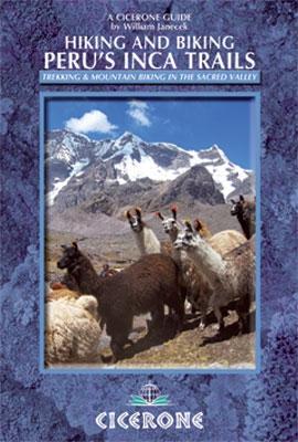
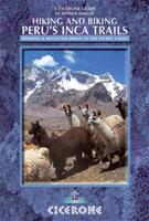
Wandelgids Peru - Hiking and Biking Peru's Inca Trails | Cicerone

0
The eastern slope of the Peruvian Andes is one of the most dramatic and diverse places on the planet, dropping from over 6000m (20,000ft) to just 200m above sea level. This dramatic drop in elevation produces a wide range of constantly changing climactic and vegetative zones – it is often possible to hike from the base of a glacier down to the jun...

Verkopers met dit product

Verkoper
Bezorging
Prijs
DeZwerver.nl logo
DeZwerver.nl
2,95
22,95

Anderen bekeken ook

Wandelgids Peru - Hiking and Biking Peru's Inca Trails | Cicerone
The eastern slope of the Peruvian Andes is one of the most dramatic and diverse places on the planet, dropping from over 6000m (20,000ft) to just 200m above sea level. This dramatic drop in elevation produces a wide range of constantly changing climactic and vegetative zones – it is often possible to hike from the base of a glacier down to the jungle in just a day or two. Combined with the countless Inca sites and ubiquitous Inca roads, this makes the Sacred Valley one of the best trekking and mountain biking destinations in the world.    Machu Picchu is well known as one of the Seven Wonders of the World, and the Inca Trail trek that leads there is nearly as famous. What is less known, however, is the vast choice of other epic adventure trips that exist in the region – treks through soaring Andean glaciers and Incan ruins, bike rides through stunning alpine and jungle scenery. Nearly every route in this book uses an Inca road or visits an Inca ruin – and most do both. The majority of…
22,95
Wandelgids - Fietsgids Hiking and Cycling the California Missions Trail - Californie | Cicerone
Guidebook to hiking or cycling the 800 mile (1289km) California Missions Trail between San Francisco Bay and San Diego. The pilgrimage trail takes in 21 historic Spanish missions and can be completed in 50-60 walking days or 2-3 weeks cycling. With 1:100,000 mapping, route description, and details of accommodation and facilities for each stage. Ancient footpaths became connecting routes between the Spanish missions, pueblos, and presidios in the period 1769 to 1823. Over time these routes became automobile roadways and were marked with bells starting in 1906 to promote and preserve the El Camino Real. Today, the California Missions Trail follows a pedestrian route through urban cities and historic towns, through forest paths and country lanes, to each of the twenty-one historic Spanish missions. The 800-mile California Missions Trail leads walkers and cyclists through some of the most scenic and historic sites of one of America's most beautiful states. The 21 missions, founded 200-250…
26,50
Wandelgids Hiking in Norway-South | Cicerone
This guide describes 10 shorter hut-to-hut treks showcasing southern Norway's wild natural beauty, with highlights including Galdhøpiggen - Norway's highest peak at 2469m - and the iconic Pulpit Rock and Kjeragbolten on the Lysefjord. The routes range from 3 to 8 days (although many can be adapted or combined to create longer or shorter routes) and cover Jotunheimen, Rondane, Dovrefjell, Trollheimen and Ryfylke. They are suitable for experienced hikers with a good level of fitness and can be walked from mid-July to the end of September.   Clear route description and mapping are provided for each hike. Stages are graded according to difficulty: although all of the routes follow waymarked trails, some cross remote and challenging terrain which may include exposed sections calling for a sure foot and a good head for heights. However, in many instances, alternatives are provided avoiding the most demanding sections. The guide also offers comprehensive advice on public transport access and…
23,95
Wandelgids - Fietsgids Hiking and Cycling in the Black Forest | Cicerone
Guidebook describing day walks, multi-stage treks and 5 cycle routes covering the north, central and southern regions of Germany's Black Forest. From easy routes for families to multi-day journeys, the walks and rides explore the many forests, villages, castles and hills near Strasbourg, Baden-Baden, Freiburg and Basle.   Seasons spring and autumn are the best times of the year to visit the Black Forest. But the cool forest glades and lofty hills make summer walking bearable. Some routes are even accessible in winter and make for magical winter wonderland walking   Centres Freiburg im Breisgau Waldkirch, Hinterzarten, Baden Baden, Baiersbronn, Titisee, Bad Wildbad, Nagold, Calw, Breisach am Rhein   Difficulty The Black Forest is a medium-height mountain range with the highest peaks around 1500m. Trails are well marked and maintained, so the terrain is not especially difficult in most parts. Good physical condition and ability to cope with sometimes steep ascends is required. Normal wa…
23,95
Wandelgids Hiking in Hong Kong | Cicerone
Although Hong Kong is often thought of as intrinsically urban, just a short distance from the big cities are lush mountains and attractive and varied countryside. This guide presents the highlights of this hiking-friendly territory, detailing 21 graded day walks and four short treks: Hong Kong Trail (presented in 3 day stages), Lantau Trail (5 days), MacLehose Trail (5 days) and Wilson Trail (5 days). The day walks - of 5 to 22.5km - cover Hong Kong, Kowloon, the New Territories and the islands and range from easy hikes suitable for families to challenging ascents of Hong Kong's highest peaks. The territory's compact nature and excellent public transport infrastructure make it easy to access the routes.   The guide has all you need to explore Hong Kong's excellent network of trails. Route description is accompanied by clear mapping and there are comprehensive notes - including Chinese place names - to help visitors navigate the public transport system. Alongside practicalities such as…
24,95
Wandelgids Pacific Crest Trail Hiking - 3-part guidebook and map books | Cicerone
A comprehensive three-book set providing all the information needed to prepare for and hike the Pacific Crest Trail (PCT), a 2650-mile hike through California, Oregon and Washington. Designed to be compact and lightweight the set is separated into three books, an introduction to the trail (130g) and two map books (200g and 170g).   The introductory book covers all at-home planning and preparation for hiking the PCT.   Detailed explanation of the trail structure, timings and how to approach the PCT Suggested itineraries for 110-, 120-, 130- and 140-day thru-hikes and an easy-going start option to aid with planning Advice on equipment and permits required on trail A background of the trail’s history A look at the wildlife, flora and fauna encountered on the trail The two map books are designed to be used on the trail, one covering the southern stages from the Mexico border to northern California at Interstate 5, the other detailing the northern stages in Oregon and Washington to the Can…
41,95
Fietsgids - Mountainbikegids Mountain biking in Slovenia - Slovenië | Cicerone
Degelijke fietsgids met 35 mountainbike routes in Slovenië. Goede beschrijvingen en duidelijke kaarten. Guidebook to 35 full and half day mountain biking routes in Slovenia. The graded routes, which range from technically not difficult but requiring a reasonable level of fitness to highly technical, requiring a high level of fitness and confident bike handling skills, vary in length from 12km to 59km. Routes are located in Gorenjska, Soca Valley, the South, as well as Central and North Eastern Slovenia.   Full route descriptions are accompanied by gradient profiles and 1:75,000 mapping, together with practical information such as getting to and around Slovenia, travelling with the bike, arranging accommodation and dealing with emergency situations. A handy Slovenian language glossary is also included.   Showcasing a remarkably diverse landscape, Slovenia is an idyllic (and incredibly, little known) mountain biking destination. From the towering peaks of Gorenjska and the stunning rive…
23,95
Fietsgids - Mountainbikegids Mountain Biking in Southern and Central Scotland | Cicerone
Degelijke fietsgids met 21 mountainbike routes in zuid en midden Schotland. Goede beschrijvingen en duidelijke kaarten.   This guidebook describes 21 mountain biking routes in central and southern Scotland. It includes the 7stanes trail centre in Dumfries and Galloway, as well as cross-country routes in the Campsie Fells, Pentland Hills and Lammermuirs, the Galloway Forest, Tweed Valley, Cheviots and Lowther Hills. The routes range from 16.5 to 66km and are graded from moderate to very hard. Taking between 2 and 7 hours to complete, they are intended for reasonably fit mountain bikers with at least some experience.   Detailed route descriptions are accompanied by 1:50,000 OS mapping, and the selected routes set out from various points across the area, including Greenock, Glentrool, Peebles and Milngavie, with good access from both Glasgow and Edinburgh. The guidebook also gives an overview of what the region's MTB trail centres have to offer, including the famous 7stanes trail cent…
24,95
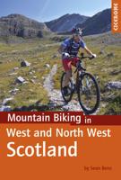
Fietsgids - Mountainbikegids Mountain Biking in West and North West Scotland | Cicerone
Degelijke fietsgids met 25 mountainbike routes in west en noord-west Schotland. Goede beschrijvingen en duidelijke kaarten.   This guidebook to  mountain biking routes in North and North West Scotland describes 25 MTB routes north of the Great Glen, Covering a large geographical area,including Fort William, Rannoch Moor, Glen Spean, Ben Nevis, Sutherland, Torridon and Skye, the routes give a real flavour of the variety of different bike riding available. The routes range from 19.5km to 73.25km, graded moderate to very hard. Many are long and committing, so good preparation and fitness are essential, and in some cases a willingness to “hike and bike”.   Each route has a clear and detailed route description along with 1:50,000 OS mapping and a height profile. All routes have key information, including distance on and off-road, ascent, grade, time and the nearest pub and cafe.  There is also advice on equipment, planning and preparation, before you hit the trails.   Scotland is rightly r…
24,95
Wandelgids Walking and Trekking in Iceland - IJsland | Cicerone
Wandelgids met beschrijvingen, kaarten en praktische informatie zoals bussen, overnachten, etc. voor meerdaagse wandelroutes en dagwandeltochten op IJsland. A country of extraordinary beauty, Iceland’s incredible variety of volcanic and glacial landscapes makes it a unique destination for walking and trekking holidays. Its three national parks include the mighty Vatnajökull, largest national park in Europe.   The wide range of routes in this book introduce walkers and backpackers to this ‘Land of Ice and Fire’. There are 100 days of walking in this guidebook, stretching over 1722km, split between 49 day walks and 10 multi-stage treks. They climb mountains, cross glaciers, pass lakes and explore coastlines and geothermal areas, and range from easy nature trails to challenging treks. So, there is enough variation to satisfy all kinds of walkers. The routes are spread all around Iceland, grouped into twelve regions. Detailed information is given at the start of each route or trekking sta…
26,95

Klanten-reviews van Wandelgids Peru - Hiking and Biking Peru's Inca Trails | Cicerone

Er zijn nog geen beoordelingen voor dit productBen jij de eerste die een review plaatst?

Meer over Wandelgids Peru - Hiking and Biking Peru's Inca Trails | Cicerone

Productomschrijving

The eastern slope of the Peruvian Andes is one of the most dramatic and diverse places on the planet, dropping from over 6000m (20,000ft) to just 200m above sea level. This dramatic drop in elevation produces a wide range of constantly changing climactic and vegetative zones – it is often possible to hike from the base of a glacier down to the jungle in just a day or two. Combined with the countless Inca sites and ubiquitous Inca roads, this makes the Sacred Valley one of the best trekking and mountain biking destinations in the world.    Machu Picchu is well known as one of the Seven Wonders of the World, and the Inca Trail trek that leads there is nearly as famous. What is less known, however, is the vast choice of other epic adventure trips that exist in the region – treks through soaring Andean glaciers and Incan ruins, bike rides through stunning alpine and jungle scenery. Nearly every route in this book uses an Inca road or visits an Inca ruin – and most do both. The majority of the Inca roads can also be biked as well as hiked, so there is plenty of scope for both activities.   There are several bases to choose from for a Sacred Valley visit: Ollantaytambo is perhaps the best base, as from here you can trek or mountain bike to Machu Picchu, Quillabamba, Choquequirao and nearly every other major site in the Sacred Valley. The town itself retains its original layout, Inca architecture and culture, and small village charm. Cusco is the largest Inca city, with attractions including museums and restaurants as well as Inca sites. It is the starting point of only a few treks, but those include the iconic routes to Machu Picchu and Choquequirao. Ausangate is the highest peak in the Cusco area, at a staggering 6270m. The region is home to some excellent hot springs, as well as various outstanding treks, and is usually accessed from the village of Tinqui.   The Andes are a formidable trekking and biking destination however. The altitude is often 3-4000m, so you will need time to acclimatise, even for the more moderate routes. The terrain is steep and rocky, which is particularly important to know for bikers when hiring a bike. Author Will Janecek has taken care to explain what to look out for when choosing your bike rental, to ensure a safe and enjoyable ride.   The routes in this guide describe the very best day and multi-day, walks and MTB routes, many previously unpublished, right across the Valley.   40 routes illustrated with custom mapping includes many alternative routes to Machu Picchu, off the main tourist trail, which don't require a licensed guide or Incan trail permit full background information on visiting the area, including how to hire bikes, guides and mules   Activities mountainbiking, hiking, trekking Seasons best months to visit are May to September, when the weather is virtually guaranteed to be dry; the other months fall in the rainy season but there will also be plenty of sunshine. Centres Agua Calientes, Cusco, Urubamba, Ollantaytambo, Huancancalle, Ausangate Difficulty the trekking and mountainbiking in the Sacred Valley is often strenuous and difficult; all routes are graded for difficulty and terrain indicated and also whether it is better to go with a trekking agency or hire a local guide; a few glacier climbs are outlined which require the correct expertise and equipment but most routes require no special equipment or skills and can be accomplished by anyone of average fitness. Must See the famous Inca Trail to Machu Picchu but also many other routes to many other Incan sites such as Choquechirau, Espiritu Pampa; spectacular Mt. Ausangate.
Productinformatie

    Verken gerelateerde categorieën

    Webshop.nl maakt gebruik van cookies. Ga je verder op onze website, ga dan akkoord met het plaatsen van cookies en de verwerking van deze data door ons en vermelde partners.