webshop.nl
Categorieën
  Sluiten

Meer Northern Eye Books

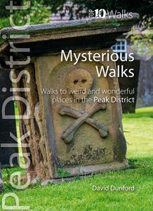
Wandelgids Mysterious Walks in the Peak District | Northern Eye Books

0
Even the Peak District’s name conceals a mystery. Forget the obvious: a visitor expecting towering peaks will be disappointed, as the name comes from the Pecsaetan tribe who once lived here. But there’s a twist: the Anglo-Saxon means “settlers of the Pec”…and that word pec has the same root as our peak, the dialect pike and the Pyrenean pic. So, ul...

Webshops met dit product

Webshop
Bezorging
Prijs

Anderen bekeken ook

Wandelgids Mysterious Walks in the Peak District | Northern Eye Books
Even the Peak District’s name conceals a mystery. Forget the obvious: a visitor expecting towering peaks will be disappointed, as the name comes from the Pecsaetan tribe who once lived here. But there’s a twist: the Anglo-Saxon means “settlers of the Pec”…and that word pec has the same root as our peak, the dialect pike and the Pyrenean pic. So, ultimately, the Peak District is named after its peaks, after all.   The Peak District is broadly defined by the conurbations at its corners: Manchester, Sheffield, Derby and Stoke. Within this rectangle, the National Park forms a rough oval of around 550 square miles.   The area is traditionally divided into the Dark Peak – peat moorland edged by gritstone, with rugged villages in the valleys — and the softer White Peak – upland pastures defined by drystone walls, divided by gorges and limestone villages. The eastern and western moors are similar to the Dark Peak, but have their own subtly distinctive characters.   The Peak District was occupi…
10,95
Reisboek - Wandelgids Wild Swimming Walks Peak District | Wild Things
The best-selling Wild Swimming Walks series returns with adventures in Britain's oldest National Park. Ascend to the highest tarns and descend through a valley of secret waterfalls * Walk through woodland gorges carved by cascades * Follow bucolic river valleys dipping as you walk. Wild Swimming Walks Peak Disitrict leads you on 28 adventures in the soaring landscape of the Peak District. Find secret waterfalls, remote lakes and sparkling river pools. Complete with photos, maps and practical guidance, rich in local history and stories, this book will appeal to wild swimmers, family explorers, nature lovers and walkers alike.   JOIN THE ADVENTURE with the best-selling Wild Swimming Walks series and explore Britain’s oldest national park from the gritstone edges of the Hope Valley, to the magical streams on the moorlands of Bleaklow, through to the picturesque limestone river dales of the White Peak.   Scramble up streams and waterfalls at Black Clough Explore fairy pools and mossy …
20,95
Wandelgids Short Walks in the Peak District | Collins
A brand new range of practical little walk guides endorsed by the Ramblers. All the walks are 5 miles or under in length and can easily be completed in less that 3 hours. 20 walks are included and use clear maps to show the route plus easy to follow walk descriptions. The Peak District, with its two very different landscapes: the gentle limestone White Peak with its intimate wooded dales and steep-sided gorges; and the wilder more dramatic gritstone Dark Peak with its wild moorland, offer some superb walking areas. This guide, produced in co-operation with the Ramblers and featuring Ordnance Survey mapping, is the perfect way to get out and enjoy the stunning scenery. This compact little guide contains walks, all of which are 5 miles or under, which are ideal for an afternoon stroll. INCLUDES: 20 easy to follow walks which can be completed in 3 hours and under Each walk has a detailed Ordnance Survey map with the route clearly marked plus a detailed description of the route The walk…
10,50
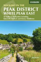
Wandelgids Walking in the Peak District - White Peak East | Cicerone
Uitstekende wandelgids van het Peak District van de gerenommeerde uitgever Cicerone.   This guidebook provides 35 day walks and 7 longer walks and trails exploring the eastern section of Derbyshire's limestone area. The walks are spread across the area, starting in pleasant towns and villages including Bakewell, Tissington, Eyam and Middleton. Largely travelling along well-marked paths over gentle rolling landscapes, these walks are suitable for walkers of all abilities.   The day walks range between 4 and 12 miles in length, and are illustrated with extracts of 1:50,000 OS mapping, while the longer walks and trails are covered by 1:100,000 scale mapping. Walkers can use the longer trails to link day walks into longer routes or explore the area on the three-day White Peak Circular, starting in Birchover.   While geologically fascinating with its layers of limestone and gritstone, the White Peak is also a landscape rich in history and art. These walks visit sites including medieval chur…
18,95
Wandelgids The Peak District | Pocket Mountains
Leuk wandelgidsje met een ruime keuze aan wandelingen, meestal tussen de 5 en 10 km. Goed beschreven en een redelijk schetsmatig kaartje. Handzaam zakformaat!   The Peak District is an upland area at the southern end of the Pennines and includes parts of Derbyshire, Greater Manchester, Staffordshire, West Yorkshire and South Yorkshire. Mostly split between the gritstone of the Dark Peak and the limestone area of the White Peak, the Peak District National Park became the UK's first national park in 1951. Tourism had been growing since the advent of the railways, with visitors attracted by the spa towns of Buxton and Matlock Bath, Castleton's show caves, and Bakewell, the national park's only town.   The stunning landscape accessed by an extensive network of public footpaths now draws outdoors enthusiasts from far and wide. This new volume from Pocket Mountains Ltd includes 40 of the most popular walks in the Peak District.
10,95
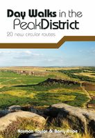
Wandelgids Day Walks in the Peak District | Vertebrate Publishing
Day Walks in the Peak District: 20 new circular routes features 20 circular walks, between 8 and 13 miles (14km and 21km) in length, suitable for hillwalkers of all abilities. The routes are split into three geographical areas - The High Moors, including the Kinder plateau and Bleaklow; Hills, Tors and Edges, including walks around the Eastern Edges such as Stanage and Burbage; and Limestone Country, with walks in the beautiful limestone dales and valleys of the Peak. Written by Peak District hillwalkers Norman Taylor and Barry Pope, each route features Ordnance Survey 1:25,000 maps, easy-to-follow directions, details of distance and navigation information, and refreshment stops and local information.
20,95
Wandelgids The Peak District | Pocket Mountains
Leuk wandelgidsje met een ruime keuze aan wandelingen, meestal tussen de 5 en 10 km. Goed beschreven en een redelijk schetsmatig kaartje. Handzaam zakformaat!   The Peak District is an upland area at the southern end of the Pennines and includes parts of Derbyshire, Greater Manchester, Staffordshire, West Yorkshire and South Yorkshire. Mostly split between the gritstone of the Dark Peak and the limestone area of the White Peak, the Peak District National Park became the UK's first national park in 1951. Tourism had been growing since the advent of the railways, with visitors attracted by the spa towns of Buxton and Matlock Bath, Castleton's show caves, and Bakewell, the national park's only town.   The stunning landscape accessed by an extensive network of public footpaths now draws outdoors enthusiasts from far and wide. This new volume from Pocket Mountains Ltd includes 40 of the most popular walks in the Peak District.
10,95

Klanten-reviews van Wandelgids Mysterious Walks in the Peak District | Northern Eye Books

Er zijn nog geen beoordelingen voor dit productBen jij de eerste die een review plaatst?

Meer over Wandelgids Mysterious Walks in the Peak District | Northern Eye Books

Productomschrijving

Even the Peak District’s name conceals a mystery. Forget the obvious: a visitor expecting towering peaks will be disappointed, as the name comes from the Pecsaetan tribe who once lived here. But there’s a twist: the Anglo-Saxon means “settlers of the Pec”…and that word pec has the same root as our peak, the dialect pike and the Pyrenean pic. So, ultimately, the Peak District is named after its peaks, after all.   The Peak District is broadly defined by the conurbations at its corners: Manchester, Sheffield, Derby and Stoke. Within this rectangle, the National Park forms a rough oval of around 550 square miles.   The area is traditionally divided into the Dark Peak – peat moorland edged by gritstone, with rugged villages in the valleys — and the softer White Peak – upland pastures defined by drystone walls, divided by gorges and limestone villages. The eastern and western moors are similar to the Dark Peak, but have their own subtly distinctive characters.   The Peak District was occupied by humans long before the Pecsaetans and in each era man has left his mark, from prehistoric standing stones and rock art, through the folk legends, crosses and churches of the Middle Ages, to post-medieval follies and puzzling relics of the extraction of lime and lead.   The varied geology of the area throws up natural curiosities too: its dark gritstone has wind-sculpted tors and edges, while its gleaming limestone hides caves and subterranean rivers.   This handy pocket size book will take you on short circular walks to the ten most fascinating, odd or strange places in the Peak District. Prepare to be amazed and surprised.

Productspecificaties

Artikelnummer(s)
Brand
Northern Eye Books
Webshop.nl maakt gebruik van cookies. Ga je verder op onze website, ga dan akkoord met het plaatsen van cookies en de verwerking van deze data door ons en vermelde partners.