Wandelgids Jurassic Coast | Cicerone

0
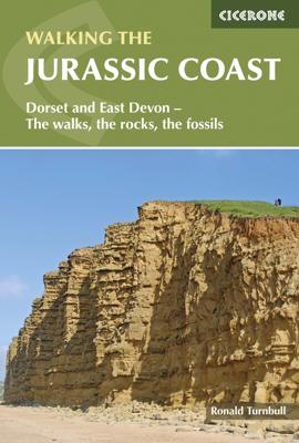
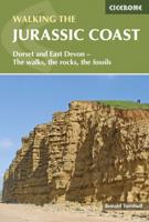
The Jurassic Coast of Devon and Dorset, stretching between Exeter and Bournemouth, is a geological wonderland. Natural wonders like Chesil Beach, Durdle Door and fossils so numerous you'll be tripping over them, combine with southern England's rolling Downs, tiny villages, beaches and sunny summers to provide a stunning and awe-inspiring landscape...

Verkopers met dit product

Verkoper
Bezorging
Prijs
DeZwerver.nl logo
DeZwerver.nl
2,95
19,95

Anderen bekeken ook

Nieuw
Wandelgids Walking in Provence - East | Cicerone
This guide offers 30 circular day walks in the eastern half of Provence, the large sun-kissed coastal region of south-east France. Spanning from the red rocks in the Ésterel on the Mediterranean to high mountains inland, the walks are set in the areas of the Alpes Maritimes, the Alpes de Haute-Provence and the Mercantour. Provence’s sunshine and Mediterranean charm attract many visitors to its coast, yet the area also has much more to offer the walker. The countryside inland boasts a range of scenery from remote mountaintops to spectacular gorges. History is everywhere, in medieval villages, arcaded streets, abbeys, churches and castles.    This guide covers the eastern regions, with its companion volume, Walking in Provence: West, covering the rest of this fascinating and historic landscape. The walking is incredibly diverse, and explores the country that hugs the Côte d'Azur and Italian border. The Alpes Maritimes rise craggy and wild above towns as unique as Grasse, Cannes and Mona…
21,95
Wandelgids The Jurassic Coast | Northern Eye Books
One of five books in the upcoming South West Coast Path: Top 10 Walks series. Handy, pocket-sized, full colour walking guides written by experts. The perfect impulse buy. Free display stands and spinners. Other titles in the new series will be: North Devon Coast, North Cornwall Coast, South Cornwall Coast, and South Devon Coast. These attractive and cleverly structured guides will give walkers ten of the best short circular walks along every section of the 630-mile long South West Coast Path in a popular pocket-size format. With clear information, an overview and introduction for each walk, expertly written numbered directions, large scale Ordnance Survey maps, superb eye-grabbing panoramic photographs, and interpretation of points of interest along the way, these guides set a new standard in clarity and ease-of-use. Featured walks in the Jurassic Coast include: Golden Cap , Chesil Beach & Abbotsbury, Portland Bill, Ringstead Bay, Durdle Door & Lulworth Cove, Kimmeridge Ledges, St Ald…
10,95
Nieuw
Wandelgids 083 Pathfinder Guides North Coast 500 and Northern Highlands | Ordnance Survey
Enhance your North Coast 500 tour with the only walking guidebook featuring routes based on or accessible from Scotland’s ultimate road trip. Discover Britain’s remotest sandy beaches, Scotland’s most northerly munro, some of the oldest rocks on Earth and more with 28 breathtaking walks accessed from the North Coast 500 as well as 32 unmissable stop-off-and-stroll recommendations.   Featured North Coast 500 and Northern Highlands walks include:   - Circle Loch Coulin where Beinn Eighe and Liathach are reflected in the still waters - Wander the astounding landscape of Knockan Crag, where some of the oldest rocks on Earth can be seen - Climb Ben Hope, Scotland’s most northerly munro, towering above the Flow Country - See the waterfalls and rocks walls of the Big Burn as you ascend Ben Bhraggie for views over the Dornoch Firth - Explore the landscape and history of the Applecross peninsula with sublime views of Raasay - Take a moorland and clifftop route to the vast golden sands of Sandw…
18,50
Wandelgids Dorset and South Devon Coast Path - South West Coast Path | Trailblazer Guides
Wandelgids van de South West Coast Path  met uitgebreide beschrijvingen wandelingen en praktische informatie met eenvoudige maar zeer accurate kaarten van de wandelroutes. This guide covers the third and last section of the South West Coast Path, from Plymouth to Poole Harbour (217 miles). This beautiful route includes 95 miles within England's only Natural World Heritage Site, the Jurassic Coast, and passes dramatic cliffs and headlands, Chesil Bank's impressive spit and Lulworth Cove, winding through idyllic seaside villages such as Beer and Lyme Regis. - 97 maps large-scale walking maps - at just under 1:20,000 - with unique mapping features: walking times, directions, tricky junctions, places to stay and eat, points of interest. These are not general-purpose maps but fully-edited maps drawn by walkers for walkers. - Itineraries for all walkers - whether walking the route in its entirety or sampling the highlights on day walks and short breaks - Practical information for all budget…
19,95
Nieuw
Wandelgids Walking in Norfolk | Cicerone
This guidebook describes 40 circular walks in Norfolk, including walks along the coast and walks exploring the Fens and the Broads. From 4 to 12 miles, these mostly flat walks use footpaths, bridleways and quiet country lanes, and some involve parts of long-distance paths, including the Peddars Way, Norfolk Coast Path, Boudica's Way and Weavers Way. The walks are divided into five sections: walks on the northeast coast and the Broads; walks in south Norfolk, the Yare and Waveney; walks in North Norfolk and the Coast; walks in Central Norfolk and Breckland; and walks in West Norfolk and the Fens. All routes are easy to moderate and can be done by anyone of reasonable fitness and enjoyed all year round.   Each route is described step-by-step, illustrated with 1:40K OS map extracts and packed with historical, geological and other information about the landscape the route passes through. The Fenland region of Norfolk's far west is flat and low-lying, as are the marshes and waterways of t…
20,95
Nieuw
Wandelgids Walking on Jura, Islay and Colonsay | Cicerone
Uitstekende wandelgids van deze weldadige eilanden. goed beschreven met veel praktische informatie om de route te kunnen lopen, inclusief redelijke kaarten. This guidebook presents a selection of 23 walking routes on the wild and beautiful southern islands of Scotland's Inner Hebrides, with nine walks on Jura, one on neighbouring Scarba, seven on Islay and five on Colonsay, plus a spectacular 5-day trek along Jura's dramatic west coast. The wildest of the southern Hebrides, the walking on Jura is frequently rugged, with many routes crossing remote and often pathless terrain that calls for fitness, self-reliance and navigational competence. The routes on the other islands are somewhat easier, but should still not be underestimated.   In addition to clear route description illustrated with 1:50,000 OS mapping, the guide offers practical advice on the various options for getting to the islands, accommodation and amenities. There are suggestions for linking walks and notes on the islands'…
20,95
Nieuw
Wandelgids Wales: The Ceredigion and Snowdonia Coast Paths | Cicerone
As part of the Wales Coast Path, the Ceredigion Coast Path and Snowdonia Coast Path trace a curve of 233km (145 miles) of coastal and inland walking down Cardigan Bay. This guidebook describes a 16-stage guide to the walk from Porthmadog to St Dogmaels covering the trail between the Llyn Peninsula and the Pembrokeshire Coast Path. .In 16 day stages from Porthmadog to St Dogmaels, this guidebook offers all the information walkers need to complete the 233km (145 miles) section of the Wales Coast Path that curve down Cardigan Bay, passing through a range of contrasting landscapes.   Six days are spent on the Snowdonia Coast Path, two around the Dyfi Estuary, seven on the Ceredigion Coast Path and one from Cardigan to St Dogmaels.   Linking the Llyn Peninsula Coast Path with that of the Pembrokeshire Coastal Path, this section takes in Snowdonia National Park’s splendid coastal plains, leads inland through beautiful hill country around the Dyfi Estuary and follows some of the finest coast…
18,50
Nieuw
Wandelgids Great Walks on the England Coast Path | Cicerone
Guidebook to 30 routes celebrating the best day and weekend walks on the England Coast Path, a new National Trail. Includes a varied selection of walks along the country's diverse shoreline, on cliff paths, estuaries, beaches and saltmarsh. Routes from 9 to 45km to suit all ages and abilities, many of which can be enjoyed all year round. At around 4500km (2800 miles), the England Coast Path is the longest coastal trail in the world. This inspirational large-format guide presents a handpicked selection of 30 highlight sections, offering a taste of England's stunning and diverse shoreline. Routes range from 9 to 45km, spanning between 3 hours and 2 days, offering options to suit all abilities. They can be accessed by public transport and are walkable year round (weather permitting!). Route descriptions are accompanied by 1:50,000 OS map extracts. Included in each walk are comprehensive listings of public transport, toilets and places to eat and drink, which highlight the excellent walki…
27,95
Nieuw
Wandelgids Walking on Rum and the Small Isles - Schotland | Cicerone
  A handy guidebook to walking and backpacking in the Western Isles of Scotland on Rum, Eigg, Muck, Canna, Coll and Tiree including a tough 55km backpack around the coast of Rum, a circuit of the Rum Cuillin and an ascent of An Sgurr (Eigg). 16 routes across all the islands suitable for a range of abilities exploring coasts, mountains and wilderness. The Small Isles, and the nearby Hebridean twins Coll and Tiree, offer adventurous walkers a fine range of routes, from the jagged volcanic peaks of the Cuillin on Rum to the beaches, dunes and machair pastures of its lower-lying neighbours. Many of the walks follow sublime coastlines, dotted with striking geological formations and teeming with wildlife.   Easier routes on Rum, along long-established paths, explore the National Nature Reserve with opportunities to spot deer, golden eagles, feral goats and Rum ponies along the way, and detailed information is included on each island's history, geology, wildlife, plants and flowers to help w…
20,95
Nieuw
Wandelgids The South West Coast Path | Cicerone
Goede wandelgids van het langste gemarkeerde wandelpad van Groot Brittanië; 1015 km! Uit de bekende Cicerone serie, dus met mooie foto's en duidelijke routebeschrijvingen en kaartjes. The South West Coast Path is Britain's longest way-marked trail, measuring a staggering 1015km (630 miles). Written by the well-known outdoor writer, Paddy Dillon, the guide provides a wealth of detailed knowledge to help tackle this immense route with confidence. It describes the way-marked trail from Minehead to Poole along the north Devon, Cornish and south Devon coastline to finish at Poole Harbour. A full introduction provides the route's historical background, advice on accommodation along the route and details on travelling to and around the South West.There is detailed information on how to use this guide to make the most of your walk, whether you choose to walk the whole route in one go or decide to achieve sections at intervals.Day-by-day route summaries accompany the 45-day stages and the fina…
24,95

Klanten-reviews van Wandelgids Jurassic Coast | Cicerone

Er zijn nog geen beoordelingen voor dit productBen jij de eerste die een review plaatst?

Meer over Wandelgids Jurassic Coast | Cicerone

Productomschrijving

The Jurassic Coast of Devon and Dorset, stretching between Exeter and Bournemouth, is a geological wonderland. Natural wonders like Chesil Beach, Durdle Door and fossils so numerous you'll be tripping over them, combine with southern England's rolling Downs, tiny villages, beaches and sunny summers to provide a stunning and awe-inspiring landscape to explore.   The 30 walks in this guide let walkers discover the best and most spectacular areas on the coast. The walks are between 5 and 25km (3 to 16 miles) and provide a range suitable for all abilities. The guide has been divided into areas: Devon's Red Beds, the Lias, Chesil Beach, Chalk walks (Lulworth and inland) and the Isle of Purbeck.    The geological descriptions are accompanied by strata diagrams, geological timelines, explanations of the creation of the various sedimentary rocks along the coast, and discussion of how and why the various formations formed millennia ago. The incredible - yet readable - detail brings these walks and the landscape alive. And yet, the routes can just as easily be walked for their own sake and the pleasure of rolling downs, high cliffs and beach sunshine.   As well as detailed descriptions for every walk, accompanied by OS maps, there are details on available parking, points of interest along the way (on rocks and other sights) and advice on the terrain covered. The general and geological introductions provide background on the region and the appendices give thorough information on local museums and information centres, cliff diagrams, a glossary of geological terms and a quick, look-up guide to the rocks of the Jurassic Coast. More than just a walking guidebook, this book is an invitation to explore and learn about this spectacular Natural World Heritage area.   Steden en Dorpen Budleigh Salterton, Sidmouth, Beer/Seaton, Lyme Regis/Charmouth, Bridport, Dorchester, Portland, Cerne Abbas, Lulworth, Swanage

Verken gerelateerde categorieën

Webshop.nl maakt gebruik van cookies. Ga je verder op onze website, ga dan akkoord met het plaatsen van cookies en de verwerking van deze data door ons en vermelde partners.