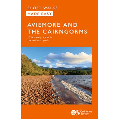
Wandelgids Aviemore and the Cairngorms | Ordnance Survey

0
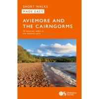
Get outside in the Cairngorms, Britain’s largest national park, with ten tried-and-tested accessible walks along the Spey Valley. Discover ancient Caledonian woodland, beautiful lochs and sparkling rivers against a backdrop of snow-capped mountains, waiting for the whole family to enjoy.   Aviemore and the Cairngorms Short Walks Made Easy include:...

Verkopers met dit product

Verkoper
Bezorging
Prijs
DeZwerver.nl logo
DeZwerver.nl
2,95
10,-

Anderen bekeken ook

Wandelgids Aviemore and the Cairngorms | Pocket Mountains
Handige compacte wandelgids met 40 dagwandelingen. Deze gids bevat kleine kaartjes en leuke uitgebreide informatie over wat er langs de route te zien is. Goede wandelkaarten zijn echter we noodzakelijk voor deze tochten: de Ordnance Survey explorer maps of Landanger maps zijn zeer geschikt. 'Aviemore and the Cairngorms' features 40 shorter walks, including many perfect for families, stretching from the ancient region of Badenoch and the uppermost reaches of the Spey Valley, through the outdoor hub of Aviemore to Grantown and Tomintoul, then over Ballater and Royal Deeside to Braemar. Plaatsen in het boekje Abernethy Forest, An Lochan Uaine, Anagach Woods, Aviemore, Badenoch Way, Ballater, Balmoral Estate, Balnagowan Wood, Black Wood, Boat of Garten, Braemar, Bridge of Brown, Burn o’Vat, Cairngorm Club Bridge, Cairngorm Ski Centre, Calder Bridge, Carn Daimh, Carrbridge, Castle Roy, Coire an t-Sneachda, Colonel’s Bed, Coylumbridge, Craigellachie Woods, Craigendarroch, Craigmore Wood, Cr…
10,95
Nieuw
Wandelgids Walking in the Cairngorms | Cicerone
Uitstekende wandelgids, sommige meerdaags, voor dit uitdagende wandelgebied in Schotland. This guidebook contains over 100 routes for walking in the Scottish Cairngorms. It includes 18 Munro summits and smaller viewpoint hills. Walks range in length from 1 to 26 miles and are graded for difficulty.    For the adventurous there are the best of the area's rocky scrambles, and the classic through-routes including the Lairig Ghru. For those looking for a more gentle alternative, there are easy, sandy trails wandering among the tall pines and along the banks of the great rivers Spey, Nethy and Dee.    Britain's biggest mountain range is home to exceptional and varied scenery - from the ancient Caledonian forest to the granite plateau, the glacial glens and high corries where green lochans lie below great crags of the plateau rim.  Along with the main Cairngorm range between Speyside and Deeside, the guidebook covers Lochnagar. It includes practical information on snack stops, public …
20,95
Wandelgids 85 Pathfinder Guides Outer Hebrides | Ordnance Survey
This new title to the Outer Hebrides represents a very welcome addition to our Pathfinder® Guide series: 28 outstanding walks – 23 circular and five there-and-back routes visiting ten islands. The size and nature of the islands lend themselves best to short and half-day walks where unhurried and free-range walking is encouraged and the endless distractions of scenery, wildlife, history and Gaelic cultural heritage are best appreciated and enjoyed at a relaxed pace.   Featured Outer Hebrides walks include:   This wonderful collection of island walks is divided into three chapters: Lewis and Harris Berneray, North Uist, Benbecula, South Uist and Eriskay Barra and Vatersay There is an illustrated introduction to each of these island groups and planning information on ferries from the mainland and inter-island connections. Walks are presented sequentially geographically, starting in Stornoway, heading up to the Butt of Lewis and then working southwards along the main touring route down th…
18,50
Wandelgids 065 Pathfinder Guides Surrey | Ordnance Survey
Fraaie, goed verzorgde wandelgidsjes met 28 wandelingen van max. een dag, (beginnend bij korte, eindigend bij langere wandelingen). Weergegeven op duidelijke topografische kaartjes (1:25.000). Bevat verder wetenswaardigheden en praktische informatie voor onderweg. Areas covered include the North Downs Way and Box Hill, with all walks accompanied by GPS waypoints, Ordnance Survey maps and beautiful photography. The Pathfinder Guide to Surrey Walks contains 28 fantastic circular walks across the county, much of which lies only a few miles away from the heart of London but which contains some of the country's most beaufiul landscapes, including the oldest untouched area of natural woodland in the UK and the rolling contours of the North Downs. Each walk in Pathfinder Guide to Surrey Walksis accompanied by clear, large-scale Ordnance Survey route maps and GPS waypoints to help you navigate your hike with ease. Exploring one of the most popular Home Counties, Pathfinder Guide to Surrey Wal…
18,50
Nieuw
Wandelgids 1 Walking The Munros Vol 1 Southern, Central and Western Highlands - Schotland | Cicerone
Uitstekende wandelgids van het zuiden, midden en westen van de Schotse Hooglanden. Goed beschreven met veel praktische informatie om de route te kunnen lopen, inclusief redelijke kaarten. Guidebook to walking the Munros in southern, central and western Highlands. Describes 69 challenging routes across 139 of the iconic 3000ft+ mountains covering areas such as Glencoe, Bridge of Orchy and Mull. Includes routes up Ben More, Ben Alder, Ben Lomond and Ben Nevis, the highest mountain in the British Isles. Volume 1 of two guidebooks.   Seasons The guide is intended for summer hillwalkers (usually April/May to October in Scotland). In winter conditions the routes become more serious mountaineering expeditions requiring appropriate skills, equipment and experience.   Centres Arrochar, Crianlarich, Killin, Pitlochry, Tyndrum, Glencoe, Fort William, Spean Bridge, Dalwhinnie, Braemar, Glenshee   Difficulty Most of the Munros are straightforward walks but some involve ridge walking, sc…
20,95
Wandelgids South Downs National Park | Ordnance Survey
Stroll up on the Downs, explore charming villages and wander woodland trails with ten hand-picked leisurely walks suitable for the whole family. Enjoy some of the loveliest and most accessible walks in the South Downs National Park and discover the benefits of being active outside.   South Downs Short Walks Made Easy include:   - Climb the Zig-Zag Path above charming Selborne, made famous by naturalist Gilbert White, for wonderful views - Explore the historic village of Bramber, once an important river port and full of intrigue, and enjoy the beautiful ‘Walk For All’ along the banks of the Adur - See the iconic Devil’s Dyke, offering great views in all directions from the hillfort above the longest and deepest dry valley in the country - Wander the Seven Sisters Country Park, part of the spectacular Sussex coastline between Eastbourne and Seaford - Follow the South Downs Way up Old Winchester Hill to find a hill-fort and barrows, as well as excellent views as far as the Solent and the…
10,95
Nieuw
Wandelgids 082 Pathfinder Guides Orkney and Shetland | Ordnance Survey
Wandelgids van een deel van Engeland. Deze gids bevat 28 dagwandelingen, variërend van korte tochten tot pittige dagtochten. De bijbehorende kaarten zijn uitstekend: men heeft de topografische kaarten van Ordnance Survey gebruikt waarop de route is ingetekend. Daarnaast praktische informatie over de wandeling en wat beschrijvingen van het gebied. 28 outstanding walks – 23 circular and five there-and-back routes visiting eleven islands across both archipelagos. The size and nature of the islands lend themselves best to short and half-day walks where unhurried and free-range walking is encouraged and the endless distractions of scenery, seabirds, wildflowers and sea watching are best appreciated and enjoyed at a relaxed pace.   In Orkney, the first walk is a short stroll around Hoxa Head with its extensive views across Scapa Flow and subsequent routes go on to explore more widely over Mainland Orkney and take in the islands of Hoy, Rousay and South Ronaldsay, concluding with a ramble al…
18,50
Nieuw
Wandelgids The Speyside Way | Rucksack Readers
Deze gids een goede beschrijving van de lange afstands route. De kaarten zijn schetsmatig maar wel duidelijk. The Speyside Way is one of Scotland’s Great Trails. It runs for 80 miles (128 km) from the fishing port of Buckie to Aviemore in the foothills of the Cairngorms. Following the lovely valley of the River Spey, you walk through countryside rich in malt whisky and wildlife, along riverside paths, railway trackbed and forest and moorland tracks.   The second edition was fully revised, with mapping from Footprint in six panels, updated plans of villages along the Way, including a fresh Grantown plan and directions from the terminus in Buckie. In 2016 we released the revised version of this essential trail guide, with fresh photos, new mapping and many other updates. These included documenting the 6.5-mile route extension to Kincraig, which opened in 2015, and 11-mile Badenoch Way.   This guidebook contains all you need to plan and enjoy the Speyside Way:   the Way step-by-step,…
22,50
Nieuw
Wandelgids 044 Pathfinder Guides Essex | Ordnance Survey
Pathfinder Guide to Essex offers excellent lowland walking in the south-east of England. The routes are all circular exploring the finer countryside of the county, in a series of parkland, farmland, woodland and coastal and estuarine walks, visiting its places of historic interest, attractive towns and charming villages. Given the pleasant and undramatic nature of the terrain, routes only really vary in length in terms of difficulty and there is a general progression through the book from shortest to longest. Beginning with a short walk linking Laindon Common with Great and Little Burstead, encountering the infant River Crouch, the book progresses to a near 10-mile excursion across Bradwell Marsh, with its wide open horizons, and a visit to the isolated and tiny Saxon chapel of St Peter-on-the-Wall. Sea air can also be taken on walks from Walton-on-the-Naze, a circuit of the eastern end of Mersea Island, along St Osyth Creek, at Maldon, from Burnham-on-Crouch, and overlooking Benfleet…
18,50
Wandelgids Snowdonia | Ordnance Survey
Everybody can explore Snowdonia, from England and Wales’ highest mountain to magical medieval castles and the spectacular Conwy coastline, with these accessible, family-friendly walks. Get outside and active with the whole family amidst the mysterious legends and natural beauty of Snowdonia.   Snowdonia Short Walks Made Easy include:   - Take Victorian tramcars or the chairlift to the summit of the Great Orme, then wander wildflower-rich meadows for incredible views of the mountains, the sea and the Isle of Anglesey - Follow the Lôn Gwyrfai trail round beautiful Llyn y Gader through Beddgelert Forest to the lovely village, with views of Snowdon and Y Garn throughout - Get off the beaten track in the valley of Cwm Penamnen with views of the cliffs of Moel Sabod and the 13th-century Dolwyddelan castle - Discover Porthmadog on a fascinating walk over Borth-y-Gest headland, the ingenious Cob and the salt marshes home to many seabirds - Explore Dolgellau and the riverside walk to Penmaenpo…
10,95

Klanten-reviews van Wandelgids Aviemore and the Cairngorms | Ordnance Survey

Er zijn nog geen beoordelingen voor dit productBen jij de eerste die een review plaatst?

Meer over Wandelgids Aviemore and the Cairngorms | Ordnance Survey

Productomschrijving

Get outside in the Cairngorms, Britain’s largest national park, with ten tried-and-tested accessible walks along the Spey Valley. Discover ancient Caledonian woodland, beautiful lochs and sparkling rivers against a backdrop of snow-capped mountains, waiting for the whole family to enjoy.   Aviemore and the Cairngorms Short Walks Made Easy include:   - Explore Loch Garten and Loch Mallachie, an RSPB Reserve and a haven for ospreys, and pine woodland filled with rare wildlife - Follow the line of the Strathspey Railway and see steam trains chugging past from Aviemore to the ‘osprey village’ of Boat of Garten - Go for a woodland ramble through Glenmore Forest Park to glacial Loch Morlich, where you can stroll the red sands of the highest beach in Britain - Wander the enchanted shores of Loch an Eileen, where a ruined castle stands on the loch’s one island - Stroll through wildflower-rich meadows on the banks of the Calder and the Spey as you circle Newtonmore - See the iconic Old Packhorse Bridge amidst glorious pinewoods at Carrbridge   Short Walks Made Easy guidebooks:   - A six-book series: Lake District, Peak District, South Downs, Aviemore and the Cairngorms, Northumberland and Snowdonia - 10 accessible walks suitable for the whole family - All routes are between 2 to 5 miles and can be completed all year round - Know what to expect before you go: Information on locations of cafes/pubs and toilets, terrain, hilliness and accessibility for pushchairs and wheelchairs - Large-scale Ordnance Survey maps for ultra-easy navigation and route-finding, featuring intuitive pictorial symbols - Numbered points which tie maps to route descriptions and walk profiles - Route photographs for each numbered point so you know exactly where you’re going - Enhance your adventure with stories behind each walk and nature notes - Get active outside and enjoy the physical and mental health benefits

Verken gerelateerde categorieën

Webshop.nl maakt gebruik van cookies. Ga je verder op onze website, ga dan akkoord met het plaatsen van cookies en de verwerking van deze data door ons en vermelde partners.