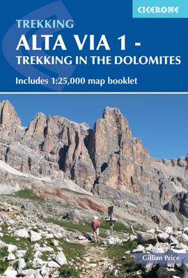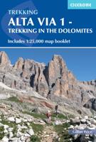
Wandelgids Alta Via 1 - Trekking in the Dolomites | Cicerone

0
Uitstekende wandelgids van een gerenommeerde Engelse uitgever. De tochten zijn met zorg beschreven en voorzien van allerhande nuttige informatie. The Alta Via 1 is one of Italy's most famous and most popular long-distance routes and is the easiest of six Alta Via routes that traverse the magnificent Dolomites. The hut-to-hut trail extends 115km fr...

Verkopers met dit product

Verkoper
Bezorging
Prijs
DeZwerver.nl logo
DeZwerver.nl
2,95
23,95

Anderen bekeken ook

Nieuw
Wandelgids Alta Via 2 - Trekking in the Dolomites | Cicerone
Uitstekende wandelgids van een gerenommeerde Engelse uitgever. De tochten zijn met zorg beschreven en voorzien van allerhande nuttige informatie. Guidebook describing Alta Via 2, a challenging hut-to-hut trek through the Italian Dolomites. Stretching 174km from Bressanone (Brixen) to Feltre, the route involves some aided and exposed sections (although several can be bypassed) calling for a sure foot and a good head for heights. It can be walked in under a fortnight - although it is also possible to walk shorter chunks should you only have limited time, and the guide highlights potential exit routes and transport options. Also included are summaries of Alte Vie 3-6, which are more demanding and include remote terrain and stretches of via ferrata for which climbing experience is essential. On Alte Vie 3-6 some nights will be spent in unmanned bivouac huts, meaning trekkers must carry their own kit, although it is possible to walk shorter hut-to-hut sections. The easiest of the Alta Via …
23,95
Nieuw
Wandelgids Trekking the Dolomites Av1 | Knife Edge Outdoor
Superhandige wandelgids voor de Alta Via 1 in de Dolomieten. Met deze gids heb je verder niks nodig: alle benodigde Tabacco wandelkaarten zitten in deze gids! The only guidebook exclusively for the AV1.Everything you need to know to plan and walk Italy's most popular long distance route.Real maps inside (Tabacco 1:25,000): the finest maps available for the Dolomites. This makes navigation easy and there is no need to carry additional maps. Also includes:* Numbered waypoints linking maps to text* Unique Itinerary Planner: plan a bespoke itinerary to match your ability and vacation schedule. All difficult calculations of time, distance and altitude gain are done for you* 7 Proposed Itineraries of between 6 and 11 days* Everything the trekker needs to know to plan the route: route descriptions, costs, budget, difficulty, weather, how to get there, and more* Full accommodation listings: spectacularly situated mountain huts* Section on Camping* Exciting variants to the main route* Informat…
19,95
Nieuw
Wandelgids Walking in the Dolomites - Dolomieten | Cicerone
Uitstekende wandelgids van een gerenommeerde Engelse uitgever. De tochten zijn met zorg beschreven en voorzien van allerhande nuttige informatie. Guidebook to 25 multi day walks in the Dolomites mountains of northeast of Italy. The walks are mostly circular and 2 to 4 days long, and take in the Marmarole, Marmolada, Civet, Sella and Cortina Dolomites among others. Includes notes on accommodation, wildlife, transport, equipment, a glossary and other practical information. This guidebook describes 25 hut-to-hut treks in the Dolomites of northern Italy, covering 15 regions including Cortina, Sella, Sesto, Marmolada and Latemar. Ranging from 11.3km to 40.8km and from two to four days, the graded routes are suitable for walkers with a reasonable level of fitness and experience of mountain terrain, and some feature exposed sections which demand a good head for heights. They take advantage of the region's network of mountain refuges and efficient public transport system, with the majority of…
23,95
Nieuw
Wandelgids The Giants' Trail: Alta Via 1 Through the Italian Pennine Alps | Cicerone
Uitstekende wandelgids van een gerenommeerde Engelse uitgever. De tochten zijn met zorg beschreven en voorzien van allerhande nuttige informatie. Italy's Alta Via 1, a 180km hiking trail through the Italian Alps following the northern flank of the Aosta Valley, boasts magnificent views of the Alpine giants: Mont Blanc, the Matterhorn, the Grand Combin and Monte Rosa. Indeed, it is sometimes known as the Giants' Trail and can be combined with a sister-route, the Alta Via 2 (covered in a separate Cicerone guide), which runs along the southern flank of the valley, to form the Tor des Geants. Stretching from Donnas to Courmayeur, the Alta Via 1 offers fantastic alpine walking, with welcoming refuges and small hotels providing overnight accommodation (and great food) along the way. The guide presents the route in two sections, for the advantage of those who can't spare the full fortnight-plus needed to walk the entire AV1. The trail is described in 16 stages, with alternative stages coveri…
23,95
Nieuw
Klimgids - Klettersteiggids - Wandelgids 2 Via Ferratas of the Italian Dolomites: Vol 2 | Cicerone
This guide covers 77 via ferrata routes in the Italian Dolomites. As part of a two-volume set of guides to the Dolomite via ferratas, this volume includes the southern Dolomite regions, in 10 areas including those of Belluno, Brenta, Trento, Lake Garda, the 'Piccole Dolomites' and San Martino di Castrozza. As well as the detailed route descriptions, the guide includes maps, advice on how to climb via ferratas, information on the local area's history and geology, how to travel to and around the Dolomites and and the best places to stay.   Many via ferratas were originally built to aid the movements of alpine military units during the First World War, and now they represent one of the major attractions in the Dolomites. They are a range of protected routes, with fixed cables, ladders and even gorge-spanning bridges, which aid ascent to places normally reserved for expert rock climbers. In recent years, old wartime routes have been restored and many new routes added to give a network of …
27,95
Wandelgids Trekking Gran Paradiso: Alta Via 2 : From Chardonney to Courmayeur in the Aosta Valley | Cicerone
A guidebook to trekking Alta Via 2, a route of 148km, from Chardonney and Courmayeur in the Gran Paradiso National Park. While not high on the difficulty scale, Alta Via 2 is strenuous, and best suited to trekkers with some alpine experience. Fittingly perfectly into a two-week time slot, the route is best undertaken between late June and late September.   The route is described across 12 stages (with a 4-stage extension option in place of Stages 6 and 7). Stages range from 5 to 18km, with stage ascent varying from 50m (Stage 8) to 1400m (Stage 9). Net ascent is 9630m. The route is described east to west so trekkers are rewarded with the beauty of Mont Blanc at the journey's end.   GPX files available to download Detailed information on travel logistics, the mountain hut network, as well as kit requirements Trek-specific Italian-English glossary included Information given on local alpine flora and wildlife Sized to easily fit in a jacket pocket
27,50
Nieuw
Wandelgids Walking the Wicklow Way | Cicerone
The Wicklow Way was the first long-distance walking trail to be established in Ireland. Coming in at 130km (81 miles), the route traverses the county of Wicklow, from Marlay Park on the outskirts of Dublin to Clonegal, just over the county border in neighbouring Carlow, and can be comfortably completed in a week. The guide also details several adjacent trails that can be interchanged with the main route, and short detours off-route (also described) lead to welcoming villages offering accommodation and a range of other facilities. The route is presented in seven stages, each with an overview followed by clear route description and mapping. There are elevation profiles and notes on local points of interest. In addition to background information about the county's history, geology, plants and wildlife, you will find all the information you need to walk the route, with helpful advice on transport, accommodation and kit. Accommodation listings, useful contacts and a glossary of Irish place…
18,95
Nieuw
Wandelgids Munich to Venice, The Traumpfad | Cicerone
Uitstekende wandelgids die in etappes de route nauwkeurig beschijft. This guidebook describes the 570km (354 mile) Traumpfad or 'Dream Way', an Alpine trek from Munich's Mariënplatz to the Piazza San Marco in Venice. The route is broken into 30 stages of between 5hrs 30mins and 9hrs, graded according to difficulty, with 5 alternative stages and the option to spend a day traversing a section of Italy's famous via ferrata in the Dolomites. Previous experience of Alpine trekking is not necessary as the route is suitable for most able walkers: however, a head for heights is essential.    Known as 'Europe’s playground', the Alps boast an unrivalled walking infrastructure and breath-taking views of angular peaks, flower-strewn valleys and verdant slopes. Hugely popular with German trekkers but little-known in the English-speaking world, Der Traumpfad revels in this stunning scenery. The route passes through German Bavaria then Austria before entering the Italian Tyrol, taking advantage of t…
23,95
Nieuw
Wandelgids Trekking the Karnischer Höhenweg | Cicerone
Uitstekende wandelgids van deze mooie route. goed beschreven met veel praktische informatie om de route te kunnen lopen, inclusief redelijke kaarten This guidebook describes the Karnischer Höhenweg, a 169km long-distance walk through the beautiful Carnic Alps which straddle the border between Austria and Italy. Following a high Alpine trail along the main ridge, the route is clearly waymarked and requires a reasonable level of fitness, a sense of adventure and a head for heights, but no special equipment or technical expertise. It can be walked between mid-July and the end of September and takes up to a fortnight, though it is possible to devise shorter itineraries taking in the highlights. The guide describes the full route of the Karnischer Höhenweg from Arnbach, near Sillian, to Arnoldstein, near Villach, and includes plenty of practical information to help you prepare for the walk. Each stage features comprehensive route description, clear mapping and fascinating insights into th…
22,50
Nieuw
Wandelgids The Cathar Way | Cicerone
Guidebook to the GR367 Cathar Way (Sentier Cathare) in the Languedoc region of southern France. The 260km waymarked trail from Port la Nouvelle on the Mediterranean to Foix traces the history of the Cathars through the Eastern foothills of the Pyrenees. Split into 13 stages and offering a northern variant, the route takes about 2 weeks to complete. Two of the southernmost départements of France, the Pyrénées-Orientales and Ariège are inextricably linked with the history of the Cathars, a heretical Christian sect who were subjected to a crusade in the thirteenth century. Striking castles built on jagged rocky precipices are a highlight of the region and a reminder of those turbulent times. This guidebook describes the 260km Cathar Way (Sentier Cathare or GR367), a long-distance trail from Port-la-Nouvelle on the Mediterranean coast to Ariége's departmental capital Foix linking several of the impressive Cathar castles. The route follows ancient footpaths, jeep tracks and country lanes a…
22,95

Klanten-reviews van Wandelgids Alta Via 1 - Trekking in the Dolomites | Cicerone

Er zijn nog geen beoordelingen voor dit productBen jij de eerste die een review plaatst?

Meer over Wandelgids Alta Via 1 - Trekking in the Dolomites | Cicerone

Productomschrijving

Uitstekende wandelgids van een gerenommeerde Engelse uitgever. De tochten zijn met zorg beschreven en voorzien van allerhande nuttige informatie.

The Alta Via 1 is one of Italy's most famous and most popular long-distance routes and is the easiest of six Alta Via routes that traverse the magnificent Dolomites. The hut-to-hut trail extends 115km from Lago di Braies to La Pissa, boasting spectacular alpine vistas. Although it demands a moderate level of fitness, it is well waymarked and follows clear well-trodden paths, making for an ideal introduction to trekking in the Dolomites.   Welcoming refuges offer meals and accommodation along the way, though camping is also possible on the middle stages (restrictions apply elsewhere). The route is presented in 11 stages, each with overview statistics, a brief summary of the day's walking and detailed route description illustrated with clear mapping. There are also comprehensive notes on the huts the route passes, with contact details and tips on facilities available.   The intro includes advice on transport, accommodation and equipment, plus suggestions for creating shorter itineraries should time be limited, and there are facts about local points of interest and background information on the region's geology, plants and wildlife. A handy map booklet is also included, showing the full route of AV1 on 1:25,000 Kompass mapping, so you don't have to carry paper maps. Famed for their striking jagged peaks and sheer rock faces, the Dolomites also bear stark reminders of the turbulent World War I years in the shape of trenches and barracks.   The AV1 is a wonderful way to experience the celebrated scenery: (weather permitting) an estimated 80% of the Dolomites can be seen from the trail, with highlights including fantastic views of the Tofane, Pelmo and Civetta and the iconic Marmolada with its glacier. If this is your first visit to the region, you'll soon see why so many fall under its spell!

Verken gerelateerde categorieën

Webshop.nl maakt gebruik van cookies. Ga je verder op onze website, ga dan akkoord met het plaatsen van cookies en de verwerking van deze data door ons en vermelde partners.