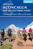
Wandelgids Aconcagua and the Southern Andes - A Trekker's Guidebook | Cicerone

0
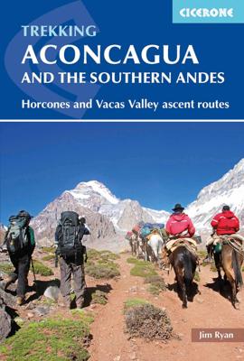
The definitive guidebook to climbing Aconcagua in South America. At 6962m, Aconcagua is the highest peak outside the Himalayas and is accessible to both trekkers and mountaineers. The book covers two popular trekking routes: the Normal (Horcones Valley) route and the Vacas Valley (Polish Glacier) route. It also includes trekking routes up Tupungat...

Verkopers met dit product

Verkoper
Bezorging
Prijs
DeZwerver.nl logo
DeZwerver.nl
niet bekend
2,95
23,95

Anderen bekeken ook

Wandelgids Aconcagua and the Southern Andes - A Trekker's Guidebook | Cicerone
The definitive guidebook to climbing Aconcagua in South America. At 6962m, Aconcagua is the highest peak outside the Himalayas and is accessible to both trekkers and mountaineers. The book covers two popular trekking routes: the Normal (Horcones Valley) route and the Vacas Valley (Polish Glacier) route. It also includes trekking routes up Tupungato, the Maipo Volcano, and other acclimatisation treks, with suggestions for things to see and do around Mendoza and Santiago City.   The guide provides a wealth of practical and indispensable information for those taking on the challenge of Aconcagua. There is information on travel to South America and to the start of the trek, and essential know-how on preparing for high-altitude mountaineering, including advice on equipment, coping with altitude, and strategies for acclimatisation. It gives expert advice on permits, food and water, hiring guides and mules, and staying healthy.   With maps and colour photos and supplemented by background inf…
23,95
Wandelkaart Trekking map Aconcagua | TerraQuest
Gedetailleerde wandelkaart - trekking map van de Aconcagua en omgeving. Handig uitgevoerd: geplastificeerd maar toch makkelijk om te slaan en op te vouwen met de gewenste kant voor. De wandelroutes staan ingetekend, zo ook de berghutten en kampen. Dé kaart om de hoogste berg van Zuid Amerika te beklimmen. Laminated topographic map of Mount Aconcagua (Argentina) published by Terra Quest in 2013. Waterproof and tear-resistant, contoured and GPS compatible map, providing coverage of the Aconcagua Provincial Park with access from the road linking Punta de Vascas, Los Penitentes, Puente del Inca and the Cristo Redentor Tunnel crossing to Chile.   The map divides the area north/south with a good overlap between the sides, extending north to Cerro La Mano on the northern boundary of the park, and south of the road to include Cerro Panitentes. A hiking map characterized by topographic data (contours). An overprint highlights the approach routes to Aconcagua, indicating main trails and difficu…
18,50
Wandelkaart trekkingmap Aconcagua | Climbing-map
Gedetailleerde kaart voor de beklimming van de Aconcagua met op de ene zijde een detailkaart van het hoogste gedeelte met schaal 1:40.000 en op de andere zijde een trekkingmap van de omgeving met de berg in een schaal van 1:100.000. Topographic and thematic climbing map with useful information and illustrations: city map of Mendoza, village map of Puente del Inca, trekking map, description of climbing routes, climatic diagram, vegetation profile, GPS information. Inhalt: Topografische und thematische Bergsteigerkarte 1:40.000 mit diversen Abbildungen und nützlichen Informationen.   Details: Vorderseite: + Topografische Karte Aconcagua im Massstab 1:40.000 + Legende + Panoramabild + Plan Boulderblöcke   Rückseite: + Trekkingkarte 1:100.000  + Streckenprofil von Trekkings und Aufstiegen + Stadtplan Mendoza  + Dorfplan Puente del Inca  + Beschreibung der Aufstiegsrouten in 4 Sprachen  + Routenskizzen von 3 verschiedenen Seiten + Vegetationsstufenprofil  + nützliche allgemeine Information…
21,95
Wandelgids Pacific Crest Trail Hiking - 3-part guidebook and map books | Cicerone
A comprehensive three-book set providing all the information needed to prepare for and hike the Pacific Crest Trail (PCT), a 2650-mile hike through California, Oregon and Washington. Designed to be compact and lightweight the set is separated into three books, an introduction to the trail (130g) and two map books (200g and 170g).   The introductory book covers all at-home planning and preparation for hiking the PCT.   Detailed explanation of the trail structure, timings and how to approach the PCT Suggested itineraries for 110-, 120-, 130- and 140-day thru-hikes and an easy-going start option to aid with planning Advice on equipment and permits required on trail A background of the trail’s history A look at the wildlife, flora and fauna encountered on the trail The two map books are designed to be used on the trail, one covering the southern stages from the Mexico border to northern California at Interstate 5, the other detailing the northern stages in Oregon and Washington to the Can…
41,95
Wandelgids Everest - A Trekker's Guide - Nepal | Cicerone
Trekkinggids met de gedetailleerde beschrijving van de klassieke Everest trek, maar ook vele varianten en dagtochten. Goede etappe-beschrijvingen met veel praktische info. Everest has an eternal appeal for mountain lovers and the classic trek to Everest Base Camp is high on the bucket-list of many trekkers. This guidebook covers the most popular route in the Khumbu Valley, from Lukla via Namche Bazaar and Gorakshep to Everest Base Camp and Kala Patthar, the best viewpoint for Everest. It also describes the classic route from Jiri to Lukla taken by Tenzing Norgay and Sir Edmund Hillary, as well as a trek north to Gokyo with its spectacular lakes and the peak of Gokyo Ri. Finally, the Three Passes Trek, also starting in Namche, links the region's major passes and valleys. The guidebook includes suggestions for side trips and time spent in Namche Bazaar, Pangboche, Dingboche and Gokyo, as well as one trek approaching Everest from Tibet – from Kharta to the Kangshung Face. It is packed wi…
24,95
Wandelgids Annapurna - A Trekker's Guide - Nepal | Cicerone
Trekkinggids met de gedetailleerde beschrijving van de klassieke Annapurna-trek, maar ook vele varianten en dagtochten. Goede etappe-beschrijvingen met veel praktische info. A comprehensive trekking guidebook to the Annapurna region - the most popular trekking area in Nepal. Fourteen diverse treks are described including the classic Annapurna Circuit and the Annapurna Sanctuary as well as treks in the lesser known Machhapuchhre area, the foothills of Lamjung Himal and restricted areas - Mustang, Damodar and Nar-Phu. This guidebook describes 14 multi-day treks in Nepal's captivating Annapurna region, among the foothills of the mighty Himalaya. Routes range between 24km and 200km (15-124 miles) and between 4 and 23 days, with maximum altitudes from 1750m to 5416m. With accommodation options including a mixture of homestay, camping and lodges, trekkers have the opportunity to immerse themselves in their surroundings and experience the warmth and richness of Nepalese hospitality and cultu…
26,50
Wandelgids Walking in the Southern Uplands | Cicerone
This guidebook describes 44 routes and over 100 summits stretching across the Southern Uplands of Scotland, stretching south-west from Edinburgh to the English border, including the Galloway and Pentland Hills. The walks range between 2 and 29km, suitable for walkers of all abilities.   The Scottish Southern Uplands is a range that is about as big as the English Pennines. It is wild hill country, with over 80 hills of 2000ft or more, and it boasts a real remoteness that is difficult to find elsewhere. All hillwalkers should experience these wonderfully characterful landscapes: green and gentle, but with hidden surprises and remote escapes.   The routes are suitable from spring to autumn, and on winter days with good weather and snow conditions. Each route provides OS mapping, information on distance, ascent, time, maximum altitude and terrain, as well as details of any variants or shortcuts. With notes on points of interest along the way as well as on transport and accommodation, the …
21,95
Wandelgids Toubkal climbing | Cicerone
A guidebook to hiking Jebel Toubkal in Morocco's Atlas Mountains and the multi-day Toubkal circuit trek. The routes are divided into summer and winter ascents with additional acclimatisation options. They are designed for hikers with some experience in summer and winter trekking at altitude.   Ascents to the Toubkal summit are detailed for both the popular Ikhibi Sud route and the less-travelled Ikhibi Nord route. The guide also includes access information from Imlil to Toubkal Basecamp, along with three winter and four summer acclimatisation options. The circular Toubkal Circuit trek explores the Toubkal National Park and is described in 6 stages covering 68km (42 miles).    Oxford Alpine Club mapping included for each route and trek stage  GPX files available to download  Detailed information on planning, facilities and transport All the 4000m peaks included Covers all beginner winter routes in the Toubkal area
23,95
Wandelgids Coniston and the Southern Lakes | Hallewell Publications
Rewalked and revised in 2019, Walks Coniston & the Southern Lakes features walks in The Lake District - the famous area of spectacular peaks and lakes in the north-west of England. This guide covers the south-western part of the area, including walks in the hills around Coniston Water and on the south Cumbrian coast. The 21 walks featured range from 1 mile to 12 miles (1.5-19km). Routes include: The Old Man of Coniston, Grizedale, Dodgson Wood to High Nibthwaite and Grange-over-Sands to Cartmel. Now on its 4th edition, this guide is part of a popular series of A6 pocket walking guides which describe routes which are suitable for walkers of all abilities and to suit all tastes. Route descriptions are accompanied by 2-colour sketch maps. The guides are illustrated with line illustrations, and will provide walkers with a good introduction to what each area covered has to offer.  
5,95
Wandelgids Walking Loch Lomond and The Trossachs | Cicerone
Uitstekende wandelgids, sommige meerdaags, voor dit uitdagende wandelgebied in Schotland. Guidebook to over 70 walking routes in the hills of Loch Lomond and the Trossachs National Park in Scotland's Southern Highlands. Including 21 Munros on less-popular routes, as well as plenty of Corbetts and Grahams. Hill summits of Ben Lomond, the Cobbler, Ben Lui and the Arrochar Alps have plenty of routes to explore. The routes in this guide range from 1 to 17 miles, and are clearly graded for distance and difficulty, as well as dividing between low-level, mid-level and mountain walks. From short, loch-side strolls suitable for all walkers, to long, challenging mountain routes with rocky scrambling, the Loch Lomond and Trossachs hills have plenty to offer.    The glens and mountains walks in this guide are divided into area: the Trossachs, Callander and Loch Lubnaig, Balquhidder and Lochearnhead, Crianlarich to Inveraran, Tyndrum, Ben Lomond, Loch Lomond West, Arrochar Alps and Glen Croe to Lo…
20,95

Klanten-reviews van Wandelgids Aconcagua and the Southern Andes - A Trekker's Guidebook | Cicerone

Er zijn nog geen beoordelingen voor dit productBen jij de eerste die een review plaatst?

Meer over Wandelgids Aconcagua and the Southern Andes - A Trekker's Guidebook | Cicerone

Productomschrijving

The definitive guidebook to climbing Aconcagua in South America. At 6962m, Aconcagua is the highest peak outside the Himalayas and is accessible to both trekkers and mountaineers. The book covers two popular trekking routes: the Normal (Horcones Valley) route and the Vacas Valley (Polish Glacier) route. It also includes trekking routes up Tupungato, the Maipo Volcano, and other acclimatisation treks, with suggestions for things to see and do around Mendoza and Santiago City.   The guide provides a wealth of practical and indispensable information for those taking on the challenge of Aconcagua. There is information on travel to South America and to the start of the trek, and essential know-how on preparing for high-altitude mountaineering, including advice on equipment, coping with altitude, and strategies for acclimatisation. It gives expert advice on permits, food and water, hiring guides and mules, and staying healthy.   With maps and colour photos and supplemented by background information on the mountain, its history, geology, wildlife and local culture, this is a comprehensive and must-read guide for anyone considering tackling Aconcagua.   Santiago, Mendoza, Puente del Inca, Los Penitentes, Tupungato

Productinformatie

    Verken gerelateerde categorieën

    Webshop.nl maakt gebruik van cookies. Ga je verder op onze website, ga dan akkoord met het plaatsen van cookies en de verwerking van deze data door ons en vermelde partners.