webshop.nl
Categorieën
  Sluiten

Meer Ordnance Survey
Meer Ordnance Survey in Literatuur boeken

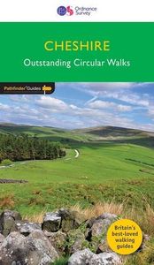
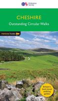
Wandelgids 42 Pathfinder Guides Cheshire | Ordnance Survey

0
175 miles of delightfully pastoral country walking from Thurstaston Common on the Wirral to Tegg's Nose on the north-western fringes of the Peak District National Park . . .   Uncover 28 beautiful walks around Cheshire with the OS Pathfinder Guidebooks, graded by length and ranging from 3 ½ to 10 ½ miles.   The routes range from extended strolls to...

Webshops met dit product

Webshop
Bezorging
Prijs

Klanten-reviews van Wandelgids 42 Pathfinder Guides Cheshire | Ordnance Survey

Er zijn nog geen beoordelingen voor dit productBen jij de eerste die een review plaatst?

Meer over Wandelgids 42 Pathfinder Guides Cheshire | Ordnance Survey

Productomschrijving

175 miles of delightfully pastoral country walking from Thurstaston Common on the Wirral to Tegg's Nose on the north-western fringes of the Peak District National Park . . .   Uncover 28 beautiful walks around Cheshire with the OS Pathfinder Guidebooks, graded by length and ranging from 3 ½ to 10 ½ miles.   The routes range from extended strolls to longer hikes, something for all levels! Each walk includes a detailed description, an OS map, GPS waypoints, and notes of key features and things to see.   This is one of a series of books with great walking routes covering the most popular and scenic areas of Britain. Printed with weather-resistant covers featuring durable rounded corners, they are the perfect companion for country walking throughout Britain.   Publication Date: 2019   Walks in this book:   Wirswall Hill and Big Mere Bollington and Nab Head Little Budworth Country Park Styal and the Bollin Valley Dane Valley Chester and the River Dee Boothsdale Astbury mere and Village Delamere Forest Audlem and the Shropshire Union Canal Bulkeley Hill and Raw Head Sandbach Disley and Lyme Park Dunham Park and the Bridgewater Canal Wybunbury Farndon and Churton Gawsworth Hall and North Rode Trent and Mersey Canal and Great Budworth Beeston Castle and the Shropshire Union Canal Caldy Hill, Thurstaston and the Wirral Way Wirral Way, Parkgate and the Dee Estuary Above Helsby and Frodsham Mow Cop and Litle Moreton Hall Timberbrook and the Cloud Shutlingsloe Mapas Tegg's Nose and Macclesfield Forest Etherow and Goyt Valley

Productspecificaties

Artikelnummer(s)
Brand
Ordnance Survey

Verken gerelateerde categorieën

Webshop.nl maakt gebruik van cookies. Ga je verder op onze website, ga dan akkoord met het plaatsen van cookies en de verwerking van deze data door ons en vermelde partners.