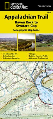
Wandelgids 1506 Topographic Map Guide Appalachian Trail - Raven Rock to Swatara Gap | National Geographic

0
Wandelgids/wandelatlas met weinig tekst, maar goede kaarten van een gedeelte van de Appalachian Trail. The Raven Rock to Swatara Gap Topographic Map Guide makes a perfect traveling companion when traversing the southeastern Pennsylvania section of the Appalachian Trail (A.T.). The map follows the ridges of the Appalachian Mountains, crosses the 12...

Verkopers met dit product

Verkoper
Bezorging
Prijs
DeZwerver.nl logo
DeZwerver.nl
2,95
16,95

Anderen bekeken ook

Wandelgids 1512 Topographic Map Guide Appalachian Trail - Mount Carlo to Pleasant Pond | National Geographic
Wandelgids/wandelatlas met weinig tekst, maar goede kaarten van een gedeelte van de Appalachian Trail.  Each A.T. Topographic Map Guide includes detailed topographic maps at a detail of 1 inch = 1 mile. Each page is centered on the A.T. and overlaps with the adjacent pages so there is little chance of getting lost. Along the bottom of each page is a trail profile that shows the distance between shelters, camping areas, and trail access points. The map and trail profile provide a step by step visual guide to hiking the trail, mile by rugged mile. The Topographic Map Guide is built for all levels of hiking enthusiasts, from the day tripper to the multi month 'thru-hiker'. The front pages of the printed Topographic Map Guide include resupply information, town inset maps, camping options, and much more. The Mount Carlo to Pleasant Pond Topographic Map Guide makes a perfect traveling companion when traversing the southern Maine section of the Appalachian Trail (A.T.). The A.T. through Main…
16,95
Nieuw
Wandelgids 1501 Topographic Map Guide Appalachian Trail - Springer Mountain to Davenport Gap | National Geographic
Wandelgids/wandelatlas met weinig tekst, maar goede kaarten van een gedeelte van de Appalachian Trail.    The Springer Mountain to Davenport Gap Topographic Map Guide makes a perfect traveling companion when traversing the Georgia, southeastern Tennessee and southwestern North Carolina, section of the Appalachian Trail (A.T.). The southern most section of the A.T. which starts at Georgia's Springer Mountain and heads north into North Carolina and Tennessee, offers some of most physically challenging, but rewarding hiking along the entire trail. The A.T. through this area is located entirely within National Park and National Forest land, and follows the ridges and balds of the beautiful and biologically diverse Southern Appalachians.   Each A.T. Topographic Map Guide includes detailed topographic maps at a detail of 1 inch = 1 mile. Each page is centered on the A.T. and overlaps with the adjacent pages so there is little chance of getting lost. Along the bottom of each page is a trail …
16,95
Nieuw
Wandelkaart - Topografische kaart 318 Mount Rogers High Country - Grayson Highlands State Park | National Geographic
Prachtige geplastificeerde kaart van het bekende nationaal park. Met alle recreatieve voorzieningen als campsites, maar ook met topografische details en wandelroutes ed. Door uitgekiend kleurgebruik zeer prettig in gebruik. Scheur en watervast!   National Geographic's Trails Illustrated map of Mount Rogers High Country and Grayson Highlands State Park, Southwest Virginia, is a two-sided, waterproof, topographic trail map designed to meet the needs of outdoor enthusiasts with unmatched durability and detail. This map was created in cooperation with local land management agencies and is loaded with valuable recreation information for exploring the area's large rock formations, spruce-fir forests, and the highest peak in Virginia. Trails and major roads, including the Appalachian Trail, the Virginia Creeper Trail, and the Virginia Highland Horse Trail, are clearly distinguished. Places of interest include areas for camping, picnicking, fishing, hiking, mountain biking, horseback riding, …
17,95
Nieuw
Wandelkaart - Wegenkaart - landkaart 100 Boulder / Golden Trail map - USA | National Geographic
  The Boulder/Golden Trails Illustrated map is the most comprehensive recreational map for the northern Colorado Front Range.   Coverage includes Boulder County Open Space Parks, City of Boulder Open Space and Mountain Parks, Jefferson County Open Space Parks, Eldorado and Golden Gate Canyon State Parks, Denver Mountain Parks, Arapaho, Roosevelt and Pike national forests. Also includes Boulder, Golden, Evergreen, Lyons, Lakewood, Morrison, and Aspen Park.   More than just a map, National Geographic Trails Illustrated topographic maps are designed to take you into the wilderness and back. Printed on tear-resistant, waterproof material, this map can go anywhere you do. Each map is based on exact reproductions of USGS topographic map information, updated, customized, and enhanced to meet the unique features of each area. The maps include valuable wilderness tips and Leave No Trace guidelines, along with updated trails, trailheads, points of interest, campgrounds, and much more. With a ne…
17,95
Nieuw
Wandelkaart - Topografische kaart 745 Adirondack Park - Old Forge - Oswegatchie | National Geographic
Prachtige geplastificeerde kaart van het bekende nationaal park. Met alle recreatieve voorzieningen als campsites, maar ook met topografische details en wandelroutes ed. Door uitgekiend kleurgebruik zeer prettig in gebruik. Scheur en watervast! National Geographic's Trails Illustrated map of Adirondack Park Old Forge/Oswegatchie is a two-sided, waterproof, topographic trail map designed to meet the needs of outdoor enthusiasts with unmatched durability and detail. This map was created in cooperation with the Adirondack Mountain Club and is loaded with valuable recreation information, no matter the season. Trails and major roads are clearly distinguished, along with canoe access and snowmobile trails. Places of interest, including the Cranberry Lake 50 Trail, campgrounds, and fishing easements, are labeled and easy to find. The map also features color coded boundaries for parklands, primitive, forest, and private property. Discover the Adirondack's wild, rugged and beautiful terrain, w…
17,95
Nieuw
Wandelkaart - Topografische kaart 744 Adirondack Park - Northville - Raquette Lake | National Geographic
Prachtige geplastificeerde kaart van het bekende nationaal park. Met alle recreatieve voorzieningen als campsites, maar ook met topografische details en wandelroutes ed. Door uitgekiend kleurgebruik zeer prettig in gebruik. Scheur en watervast! National Geographic's Trails Illustrated map of Adirondack Park Northville/Raquette Lake is a two-sided, waterproof, topographic trail map designed to meet the needs of outdoor enthusiasts with unmatched durability and detail. This map was created in cooperation with the Adirondack Mountain Club and is loaded with valuable recreation information for boating, hiking, fishing, sailing, cycling, ice fishing, skiing, and snowmobiling. Trails and major roads are clearly distinguished, from the picturesque foothills to the northern peaks and around lakes of all sizes. Campgrounds, climbing areas, marinas, and museums are labeled and easy to find and boundaries for park lands, wilderness, primitive, forest, and protected areas are clearly marked. Disc…
17,95
Wandelkaart - Topografische kaart 746 Adirondack Park - Saranac - Paul Smiths | National Geographic
Prachtige geplastificeerde kaart van het bekende nationaal park. Met alle recreatieve voorzieningen als campsites, maar ook met topografische details en wandelroutes ed. Door uitgekiend kleurgebruik zeer prettig in gebruik. Scheur en watervast!   National Geographic's Trails Illustrated map of Adirondack Park Saranac/Paul Smiths is a two-sided, waterproof, topographic trail map designed to meet the needs of outdoor enthusiasts with unmatched durability and detail. This map was created in cooperation with the Adirondack Mountain Club and is loaded with valuable recreation information, from the marsh to the forest, alongside lakes and through historic neighborhoods. Trails and major roads are clearly distinguished, along with canoe access and ski areas. Campgrounds, lookout towers, rock climbing, and fishing easements are labeled and easy to find and boundaries for park lands, wilderness, primitive, forest, and protected areas are clearly marked. Discover the Adirondack's wild, rugged a…
17,95
Fietsgids the Bikepacker's Guide to the World | Lonely Planet
Take your bicycle on the ride of a lifetime with the help of The Bikepackers' Guide to the World. Discover 75 of the most amazing cycling routes in every continent and use the detailed maps, directions, accommodation and practical information to plan your trip. Lonely Planets experts tell you how to prepare, what to take, when and where to go. Bikepacking is the fast-growing adventure activity that gives people the freedom to discover the world in a sustainable and slow-paced fashion on their bicycles. The number of new purpose-built, long-distance cycling routes is increasing all the time and this comprehensive book selects the top 75 to add to your bicycling bucket list. Lonely Planet describes the route in step-by-step detail with a large, accurate map and elevation profile helping cyclists pick a route that suits their experience. The routes are graded from easy to challenging and cover a range of distances from a weekend to a month or more. The rides vary from easy-going rail tra…
34,95
Wandelgids Canadian Rockies Trail Guide | Summerthought
The best loved and most detailed Canadian Rockies hiking guidebook is now in full color.   First published in 1971 and now in its 10th edition, the Canadian Rockies Trail Guide was the original guidebook with accurate distances and detailed descriptions to the trails of the Canadian Rockies.   Whether you’re a Canadian Rockies local or a visitor, the Canadian Rockies Trail Guide provides the best resource for hiking in the region, with everything from short interpretive trails to week-long backcountry treks. Now in its 10th edition and known affectionately as the “Bible” by outdoor enthusiasts, the popular tome is the most comprehensive and well-known guidebook to hiking in the region.   Having spent their entire adult lives hiking in the Canadian Rockies and writing about their experiences, authors Brian Patton and Bart Robinson are regarded as the ultimate authority on hiking in the Canadian Rockies. The Canadian Rockies Trail Guide is the only hiking guide to the region recommended…
29,95
Wandelkaart - Topografische kaart 261 Grand Canyon | National Geographic
Prachtige geplastificeerde kaart van het bekende nationaal park. Met alle recreatieve voorzieningen als campsites, maar ook met topografische details en wandelroutes ed. Door uitgekiend kleurgebruik zeer prettig in gebruik. Scheur en watervast!   Explore the uniquely inspiring and wondrous landscape of the Grand Canyon with National Geographic's Trails Illustrated map of Grand Canyon National Park, North and South Rims. Expertly researched and created in partnership with local land management agencies, this map is designed to meet the needs of outdoor enthusiasts with unmatched detail of the heart of the park. Key areas of interest featured on this map include Colorado River miles 60-98, North and South Rim visitor centers, Grand Canyon Village, Tusayan, Bright Angel Trail (plus elevation profile), West Rim Trail, Kaibab Trail, Arizona Trail, and more.   With miles of mapped trails in some of the most breathtaking scenery in the entire country, the Grand Canyon North and South Rims ma…
16,95

Klanten-reviews van Wandelgids 1506 Topographic Map Guide Appalachian Trail - Raven Rock to Swatara Gap | National Geographic

Er zijn nog geen beoordelingen voor dit productBen jij de eerste die een review plaatst?

Meer over Wandelgids 1506 Topographic Map Guide Appalachian Trail - Raven Rock to Swatara Gap | National Geographic

Productomschrijving

Wandelgids/wandelatlas met weinig tekst, maar goede kaarten van een gedeelte van de Appalachian Trail.

The Raven Rock to Swatara Gap Topographic Map Guide makes a perfect traveling companion when traversing the southeastern Pennsylvania section of the Appalachian Trail (A.T.). The map follows the ridges of the Appalachian Mountains, crosses the 12-mile wide, agriculturally rich Cumberland Valley, and weaves in and out of suburbia. This section of trail, which is notoriously rocky, is rich in history with traces of early industry—charcoal furnaces, railroads, and coal mining.   Scale 1/63 360 (1 cm = 633 m). 1 inch = 1 mile.  


This topographic Map Guide is printed on a waterproof, tear-resistant paper. A full UTM grid is printed on the map to aid with GPS navigation.   Each A.T. Topographic Map Guide includes detailed topographic maps at a detail of 1 inch = 1 mile. Each page is centered on the A.T. and overlaps with the adjacent pages so there is little chance of getting lost. Along the bottom of each page is a trail profile that shows the distance between shelters, camping areas, and trail access points. The map and trail profile provide a step by step visual guide to hiking the trail, mile by rugged mile. The Topographic Map Guide is built for all levels of hiking enthusiasts, from the day tripper to the multi month 'thru-hiker'. The front pages of the printed Topographic Map Guide include resupply information, town inset maps, camping options, and much more.

Verken gerelateerde categorieën

Webshop.nl maakt gebruik van cookies. Ga je verder op onze website, ga dan akkoord met het plaatsen van cookies en de verwerking van deze data door ons en vermelde partners.