webshop.nl

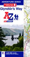
Wandelatlas Adventure Atlas Glyndwr's Way | A-Z Map Company

0
AZ heeft de meest gedetailleerde wandelkaarten van de Glyndwr's Way gebundeld in een atlasje. Daardoor is het heel handig qua formaat. De kaarten zelf zijn perfect voor het wandelen. Schaal 1:25.000 The A-Z Adventure Series of maps combines the best of OS and A-Z, creating the perfect companion for walkers, off-road cyclists, horse riders and anyo...

Webshops met dit product

Webshop
Bezorging
Prijs
DeZwerver.nl logo
DeZwerver.nl
niet bekend
12,95

Anderen bekeken ook

Opruiming - Wandelatlas Adventure Atlas Norfolk Coast Path Peddars Way | A-Z Map Company
OUDE DRUK   AZ heeft de meest gedetailleerde wandelkaarten van het zuidelijke deel van het Lake District gebundeld in een atlasje. Daardoor is het heel handig qua formaat. De kaarten zelf zijn perfect voor het wandelen.      The A-Z Adventure Series of maps is the perfect companion for walkers, off-road cyclists, and anyone wishing to explore the great outdoors.   Together, Peddars Way and the Norfolk Coast Path form a 93 mile (150km) National Trail across west Norfolk and along its northern coast. The route is clearly shown on the map and passes through a rich landscape with fantastic scenery, places of interest, and an abundance of wildlife.   This National Trail Map features detailed mapping at a scale of 1:25 000, providing complete coverage of Peddars Way and the Norfolk Coast Path. There is also a route planner included to show distances between places and the amenities available making it easy to plan your adventure. Additional features include:   Information Centres…
5,-
Wandelatlas Adventure Atlas Minehead to Brean Down - England Coast Path | A-Z Map Company
Gedetailleerde wandelkaart van een gedeelte van het England Coast Path.   The A-Z Adventure Series of maps combines the best of OS and A-Z, creating the perfect companion for walkers, off-road cyclists, horse riders and anyone wishing to explore the great outdoors.   This official* Minehead to Brean Down Adventure Map covers a 58 mile (93km) section of the England Coast Path, a new National Trail around England's coast. More than just a path, it represents a new right of way that gives everyone the legal right to explore the coast for the very first time. Opening in sections, the England Coast Path is scheduled to complete in 2020.   The path along the Somerset coastline has marvellous seaward and inland views with access to sandy beaches and shores rich with geology. Salt marshes, sand dunes and mudflats provide a vital habitat for wildlife, especially birds. A number of seaside towns along the way provide the opportunity for refreshment.   This self-covered sheet map is double sided…
7,95
Stadsplattegrond Pocket Street Map Bath | A-Z Map Company
This up-to-date detailed A-Z street map includes more than 1,700 streets in and around Bath. This street map includes the following: Postcode districts, one-way streets and car parks Tourist attractions and places of interest marked On the reverse side of the map there is a handy index to streets, places of interest, place and area names, park and ride sites, national rail stations, hospitals and hospicesIdeal companion to a sat-nav - it enables route planning and route sense-checking Extensive mapping covers an area from Charlcombe in the north to Combe Down in the south, and from Bathampton Down in the east to Whiteway in the west. With clear mapping at a scale of 5.5 inches to 1 mile, this is the perfect reference map for finding your way around Bath.
7,95
Wandelkaart - Topografische kaart 181 OS Explorer Map Chiltern Hills North | Ordnance Survey
The essential map for outdoor activities in Chiltern Hills North. The OS Explorer Map is the Ordnance Survey's most detailed folding map and is recommended for anyone enjoying outdoor activities including walking, horse riding and off-road cycling. This map now comes with a digital version which you can download to your smartphone or tablet.Providing complete GB coverage, the OS Explorer map series details information essential in the great outdoors, including youth hostels, pubs and visitor information. Rights of way, fences, permissive paths and bridleways are clearly shown, ensuring you have the best information to get the most out of your time in the countryside. FeaturesIcknield Way RidgewayNorth Buckinghamshire Way Icknield Way PathSwan's Way Two Ridges Link Aylesbury RingSouth Bucks Way Chess Valley Walk Chiltern Link Thame Valley WalkGrand Union Canal Walk Midshires Way Bledlow Circular Ride Hertfordshire Way Chiltern WayRidgeway (National Trail) Bedfordshire Buckinghamshire H…
19,50
Wandelkaart - Topografische kaart 179 OS Explorer Map Gloucester, Cheltenham, Stroud | Ordnance Survey
The essential map for outdoor activities in Gloucester, Cheltenham and Stroud. The OS Explorer Map is the Ordnance Survey's most detailed folding map and is recommended for anyone enjoying outdoor activities including walking, horse riding and off-road cycling. This map now comes with a digital version which you can download to your smartphone or tablet.Providing complete GB coverage, the OS Explorer map series details information essential in the great outdoors, including youth hostels, pubs and visitor information. Rights of way, fences, permissive paths and bridleways are clearly shown, ensuring you have the best information to get the most out of your time in the countryside. FeaturesCotswold Way Severn Way Gloucestershire Way Macmillan Way Wysis WayCotswold Way (National Trail) GloucesterCheltenhamGloucester Stroud1:25 000 scale (4 cm to 1 km - 2.5 inches to 1 mile) Met zijn 4cm voor 1 km (2 ½ cm voor 1 mijl) schaal, is de OS Explorer kaartenserie de ideale en meest gedetailleerd…
19,50
Wandelkaart National Trail Map Peddars Way and Norfolk Coast | Collins
Overzichtskaart op vrij grove schaal van deze LAW Lange Afstands Wandeling in Engeland. Let op: je kunt er niet op lopen. Wel met veel informatie op de kaart, goed ingetekend, een route-schema op de achterzijde en een beschrijving van een aantal bezienswaardigheden.  Perfect guide and map for planning your adventure along Peddar’s Way and the Norfolk Coast Path. This incorporates part of the newly formed England Coast Path.   Highlights of this Planning Map include:   More than 20 highlighted places of interest with detailed descriptions and attractive photographs, including: the Hunstanton striped cliffs, Blakeney Point, and Binham Priory A comprehensive index to more than 600 cities, towns and villages A clear, visible route plotted across a 2.4 miles to 1 inch (1.5 km to 1 cm) scale map Advice on safety and security when travelling along the route, as well as the countryside code and the code of conduct Part of the National Trail network, these two long-distance footpaths cover 93 …
11,50
Wandelkaart National Trail Map South Downs Way | Collins
Overzichtskaart op vrij grove schaal van deze LAW Lange Afstands Wandeling in Engeland. Wel met veel informatie op de kaart, goed ingetekend, een route-schema op de achterzijde en een beschrijving van een aantal bezienswaardigheden. ALs je voor lichtgewicht gaat, is dit al vrijwel voldoende om met de bewegwijzering ter plekke de route te kunnen lopen. Perfect guide and map for planning your adventure along the South Downs Way.   Highlights of this Planning Map include:   More than 20 highlighted places of interest with detailed descriptions and attractive photographs, including: Brighton Pier, The Long Man of Wilmington, and Seven Sisters A comprehensive index to more than 800 cities, towns and villages A clear, visible route plotted across a 2 miles to 1 inch ( 1.25 km to 1 cm) scale map Advice on safety and security when travelling along the route, as well as the countryside code and the code of conduct Part of the National Trail network, this long distance footpath covers 100 miles…
11,50
Wandelkaart - Topografische kaart OL32 OS Explorer Map Winchester | Ordnance Survey
Met zijn 4cm voor 1 km (2 ½ cm voor 1 mijl) schaal, is de OS Explorer kaartenserie de ideale en meest gedetailleerde kaartenreeks voor mensen die graag outdoor-activiteiten zoals fietsen, wandelen, paardrijden, klimmen en watersporten. Deze kaart is nog gedetailleerder dan de 'gewone' Landranger maps. Voor- en achterzijde bedrukt! Zeker op de moors en andere natuurgebieden van onschatbare waarden met echt alle aspecten van het landschap op de kaart ingetekend. Zeer goede detailkaart met topografische ondergrond. Hierop zijn toeristische symbolen van bezienswaardigheden ingetekend, daarnaast staan bijvoorbeeld campings en jeugdherbergen vermeld en - voor wandelaars het belangrijkst - alle right of way paden en Lange afstands Wandelpaden zijn er op te vinden. De ideale kaart voor het wandelen in Engeland, Wales of Schotland.   Map sheet OL 32 in the OS Explorer map series is the ideal map for days out in the Winchester area. Winchester, capital of England in Saxon times is a beautiful c…
19,50
Wegenkaart - landkaart Kgalagadi - Tourist Map of Kgalagadi Transfrontier Park Botswana | Shell
Zeer bijzondere landkaart van het grensgebied van Botswana en Zuid Afrika. Uitermate handig zijn de GPS coordinaten van de meest belangrijke punten als campings of uitzichtpunten. De kaart is gebaseerd op een luchtfoto, waarbij alle details zijn ingetekend. The map: The map consists of a large map of the entire Park on the front of the map. On the back is enlargements of six maps - the South African side, Mabuasehube, Swart Pan area, Gemsbok Wilderness Trail, Mabuasehube Wilderness Trail and of the Kaa Kalahari Concession. Satellite images were used and the roads were tracked by GPS. There are 168 GPS coordinates on this map. Establishment of a Transfrontier Park: On the 7 th of April 1999 Botswana and South Africa signed a bilateral agreement in which they agreed to manage their adjacent national parks, Gemsbok National Park in Botswana and Kalahari Gemsbok National Park in South Africa, as a single ecological unit – the Kgalagadi Transfrontier Park. It is the first formally declared…
17,50
Wandelkaart - Topografische kaart OL52 OS Explorer Map | Active Glen Shee - Braemar | Ordnance Survey
Met zijn 4cm voor 1 km (2 ½ cm voor 1 mijl) schaal, is de OS Explorer kaartenserie de ideale en meest gedetailleerde kaartenreeks voor mensen die graag outdoor-activiteiten zoals fietsen, wandelen, paardrijden, klimmen en watersporten. Deze kaart is nog gedetailleerder dan de 'gewone' Landranger maps. Voor- en achterzijde bedrukt! Zeker op de moors en andere natuurgebieden van onschatbare waarden met echt alle aspecten van het landschap op de kaart ingetekend. Zeer goede detailkaart met topografische ondergrond. Hierop zijn toeristische symbolen van bezienswaardigheden ingetekend, daarnaast staan bijvoorbeeld campings en jeugdherbergen vermeld en - voor wandelaars het belangrijkst - alle right of way paden en Lange afstands Wandelpaden zijn er op te vinden. De ideale kaart voor het wandelen in Engeland, Wales of Schotland.   Famous for Scotland's biggest Ski Area, OS Explorer Map OL 52 also includes part of the Cairgorms National Park, 12 Munros, the Cateran Trail and the village of B…
25,95

Klanten-reviews van Wandelatlas Adventure Atlas Glyndwr's Way | A-Z Map Company

Er zijn nog geen beoordelingen voor dit productBen jij de eerste die een review plaatst?

Meer over Wandelatlas Adventure Atlas Glyndwr's Way | A-Z Map Company

Productomschrijving

AZ heeft de meest gedetailleerde wandelkaarten van de Glyndwr's Way gebundeld in een atlasje. Daardoor is het heel handig qua formaat. De kaarten zelf zijn perfect voor het wandelen. Schaal 1:25.000

The A-Z Adventure Series of maps combines the best of OS and A-Z, creating the perfect companion for walkers, off-road cyclists, horse riders and anyone wishing to explore the great outdoors. Glynd r's Way is a 135 mile (217 km) National Trail in mid-Wales from Knighton to Welshpool via Machynlleth. Linking locations connected with Owain Glynd rs, the trail passes through the tranquil Radnorshire Hills and across open moorland and rolling farmland with views over Cadair Idris and Lake Vyrnwy. The route on the map is clearly highlighted in yellow with mileage markers to gauge distances when planning sections of the walk to enjoy. This official National Trail Map* of Glynd r's Way features 43 pages of continuous Ordnance Survey 1:25000 mapping providing complete coverage of Glynd r's Way.

The atlas includes a route planner showing distances between places and the amenities available, featuring: Information Centres, Hotels/B&Bs, Youth Hostels, Campsites (seasonal opening), Public Houses, Shops, Restaurants, Cafes (seasonal opening) and Petrol Stations. Also featured is advice on safety and security when walking and a selection of QR codes linked to useful websites, including temporary route updates from the National Trails, regional information, map reading advice and weather reports. Unlike the original OS sheets, this A-Z Adventure Atlas includes a comprehensive index to towns, villages, hamlets and locations, natural features, nature reserves, car parks and youth hostels, making it easy to find the required location quickly. Each index entry has a page reference and a six figure National Grid Reference. With a book size of 240mm x 134mm it is the same size as the standard OS folded map

Verken gerelateerde categorieën

Webshop.nl maakt gebruik van cookies. Ga je verder op onze website, ga dan akkoord met het plaatsen van cookies en de verwerking van deze data door ons en vermelde partners.