Meer Fiftiesstore
Meer Fiftiesstore in Vintagejurken

Timeless Valerie Anglaise Dress Lilac-XL

0
Picnic in the park, anyone? The Valerie Dress makes the perfect  springtime outfit, whichever way you choose to style it! The gathered bust is complimented by a fitted waist with matching button detailing and a generously flared swing skirt made for twirling your heart's content. Pair it up with some heels for that garden party you might have plann...

Verkopers met dit product

Verkoper
Bezorging
Prijs

Anderen bekeken ook

Reisboek - Wandelgids Wild Swimming Walks Peak District | Wild Things Publishing
The best-selling Wild Swimming Walks series returns with adventures in Britain's oldest National Park. Ascend to the highest tarns and descend through a valley of secret waterfalls * Walk through woodland gorges carved by cascades * Follow bucolic river valleys dipping as you walk. Wild Swimming Walks Peak Disitrict leads you on 28 adventures in the soaring landscape of the Peak District. Find secret waterfalls, remote lakes and sparkling river pools. Complete with photos, maps and practical guidance, rich in local history and stories, this book will appeal to wild swimmers, family explorers, nature lovers and walkers alike.   JOIN THE ADVENTURE with the best-selling Wild Swimming Walks series and explore Britain’s oldest national park from the gritstone edges of the Hope Valley, to the magical streams on the moorlands of Bleaklow, through to the picturesque limestone river dales of the White Peak.   Scramble up streams and waterfalls at Black Clough Explore fairy pools and mossy…
20,95
Timeless Valerie Mustard Anglaise Dress-XL
Picknick in het park, iemand? De Mustard Valerie Dress is de perfecte lente-outfit, hoe je hem ook wilt stylen! De geplooide buste wordt gecomplimenteerd door een aansluitende taille met bijpassende knoopdetails en een royaal uitlopende swingrok gemaakt om naar hartenlust te draaien. Combineer hem met hakken voor dat tuinfeest dat je misschien hebt gepland of draag hem naar een parkpicknick met witte sneakers. Stof Samenstelling | Buitenkant: 100% biologisch katoen Broderie Anglaise Voering: 100% katoenen voile voering. Met zakken!
84,50
Timeless Valerie Anglaise Dress Cerise -XL
Picknick in het park, iemand? De Valerie Dress is de perfecte lente-outfit, hoe je hem ook wilt stylen! De geplooide buste wordt gecomplimenteerd door een aansluitende taille met bijpassende knoopdetails en een royaal uitlopende swingrok gemaakt om naar hartenlust te draaien. Combineer hem met hakken voor dat tuinfeest dat je misschien hebt gepland of draag hem naar een parkpicknick met witte sneakers. Stof Samenstelling | Buitenkant: 100% biologisch katoen Broderie Anglaise Voering: 100% katoenen voile voering. Met zakken!
84,50
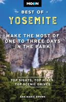
Reisgids Best of Yosemite | Moon Travel Guides
Whether you're visiting the park for a day hike or spending a long weekend under the stars, escape to the great outdoors with Moon Best of Yosemite. Inside you'll find: Easy itineraries for one to three days in Yosemite National Park, from a morning drive along the Tioga Pass Road, to a day hike along the Panorama Trail, to a full weekend exploring the park The top hikes in Yosemite: Whether you're looking to stretch your legs for a couple hours or challenge yourself to an epic trek, you'll find trailheads, detailed trail descriptions, individual maps, mileage, and elevation gains Can't-miss experiences: Make it the perfect getaway for you with the best waterfalls, views, picnic spots, and more. Ride the open-air tram through Yosemite Valley or hike downhill from Glacier Point past roaring waterfalls. Admire the towering trees in the Mariposa Grove of Giant Sequoias, or spot black bears and bighorn sheep Stunning full-color photos and maps throughout, plus a full-color foldout …
23,50
Wandelkaart 17 Banff - Egypt Lake | Gem Trek Maps
Mooie, gedetailleerde kaart uit de serie van Gem Trek Hiking map-guides. Helder kleurgebruik en met de beste / mooiste wandelroutes, hikes en interessante plaatsen erop aangegeven. Gem Trek’s 1:50,000-scale BANFF–EGYPT LAKE MAP covers the most popular hiking trails in the immediate area of the town of Banff in more detail than our Banff & Mount Assiniboine Map.   The Banff–Egypt Lake Map features detailed cartography, accurate hiking trails with distances, and details such as side trips and backcountry campgrounds. For road travellers, it includes viewpoints, picnic areas, and campgrounds.   On the back of the map are trail descriptions of 17 recommended day hikes and four classic multi-day trips, all referenced to the map on the front. Also on the back is a list of trails recommended for early season, birdwatching, wildflowers, waterfalls, expansive views, awe-inspiring scenery, alpine meadows and rainy days. Included are contact numbers for visitor centres and backcountry booki…
17,95
Wandelkaart 03 Bow Lake / Saskatchewan Crossing | Gem Trek Maps
Waterproof and tear-resistant hiking and recreation map for the Bow Lake and Saskatchewan Crossing region of Banff National Park.   Gem Trek's 1:70,000 Bow Lake and Saskatchewan Crossing Map is designed for outdoor enthusiasts looking to explore the Bow Lake and Saskatchewan Crossing region at the north end of Banff National Park. Whether you are touring along the roads or heading into the backcountry, you’ll find the waterproof and tear-resistant Bow Lake and Saskatchewan Crossing Map to be an invaluable tool. This map features detailed cartography, accurate hiking trails with distances, and details such as logging roads on the British Columbia side of the Continental Divide, campgrounds, picnic areas, and abandoned fire lookouts. On the back are descriptions of 24 recommended hikes, ranging from short walks to overnight treks, as well as details of services such as campgrounds and visitor centres.   Map specs     – Edition: 6th – Map scale: 1:70,000 – Sheet size: 27 x 39 inches – Fo…
18,95
Reisgids Best of Grand Canyon | Moon Travel Guides
Whether you're stopping for a day hike or spending a long weekend under the stars, escape to the great outdoors with Moon Best of Grand Canyon. Inside you'll find: Easy itineraries for one to three days in Grand Canyon National Park, from a morning bike ride along the South Rim, to a day hike in the inner canyon, to a full weekend exploring the park The top hikes in Grand Canyon: Whether you're looking to stretch your legs for a couple hours or challenge yourself to an epic trek, you'll find trailheads, detailed trail descriptions, individual maps, mileage, and elevation gains Can't-miss experiences: Make it the perfect getaway for you with the best views, scenic drives, picnic spots, and more. Trek into Havasu Canyon to see stunning waterfalls or drive to viewpoints along Hermit Road. Go on a rafting adventure on the Colorado River and spot wildlife like elk and bighorn sheep Stunning full-color photos and maps throughout, plus a full-color foldout map Essential planning tips…
19,95
Wandelkaart - Topografische kaart 748 Green Mountain National Forest South - Robert T. Stafford White Rocks NRA - Manchester | National Geographic
Prachtige geplastificeerde kaart van het bekende nationaal park. Met alle recreatieve voorzieningen als campsites, maar ook met topografische details en wandelroutes ed. Door uitgekiend kleurgebruik zeer prettig in gebruik. Scheur en watervast! National Geographic's Green Mountain National Forest South Trails Illustrated topographic map is the most comprehensive available for outdoor enthusiasts of all types. Designed to be easy-to-read, yet highly detailed – this map includes a comprehensive road and trail network distinguishing between major, secondary and 4x4 roads, hiking, horse, biking, multi-use and non-motorized winter trails. All forest roads are labeled with their official road number and trails are clearly identified with their given name. Land management boundaries are color-coded showing National Forest, Ranger District, Wilderness Areas, Conservation Areas and more, plus the locations of private land within the Green Mountain National Forest. The renowned Appalachian Trai…
17,95
Wegenkaart - landkaart Jasper National Park & Northern Alberta | ITMB
  Jasper National Park kaart, zeer gedetailleerd (schaal 1:250.000) plus op de anderekant van de kaart staat Noord Alberta, schaal 1:1.000.000. Natuurkundige overzichtskaart met veel plaatsen en wegen, spoorlijnen en rivieren, hoogten, lengte- en breedtegraden.   Two words immediately come to my mind if I were to describe Northern Alberta: Oil and Cold. Oil sands could be found relatively easily within the Northern Alberta region. This pushes the Canadian economy forward as gasoline and other petroleum products are becoming higher in demand. Northern Alberta is also about the subzero temperature. The region of Northern Alberta mostly contains very cold, long winters and warm, short summers. Fort McMurray, for example, one of the famous urban communities located in the Wood buffalo municipality, has only a yearly mean temperature of 0.7 degrees Celsius. Nonetheless, Northern Alberta is also a land of recreation activities and wild adventures. On the other side of the Northern Alberta …
13,95
Wegenkaart - landkaart - Stadsplattegrond Toronto & Southern Ontario - Ontario zuid | ITMB
Overzichtskaart van het zuiden van Ontario - schaal 1:600.000 - met op de andere kant een grote plattegrond van Toronto op schaal 1:12.000 Legend Includes: Roads by classification, Accomodations, Museum, Churches, Buildings, Points of tourist, Public Interests, Post Offices, Police Stations, Schools, Live Theatres, Cinemas, Ruins, Bus Terminals, Ferry Terminals, Service Areas, Hospitals, Ports, Mines, RCMP, Major Airports, Secondary Airports, Camp Grounds, National Park and Equivalent Reserves, Ski, Picnic Sites, and much more.   Toronto is the largest city in Canada by far. Touristically, its attraction rests with its central core, from High Park in the west to the Don River in the east, and from the park-like islands in Lake Ontario to Bloor Street in the north. In this area, one finds remnants of the oldest portion of ‘muddy York’, the original fort built to deter American raiders (close to the exhibition grounds), Campbell House (at Queen & University), and the first public schoo…
13,95

Klanten-reviews van Timeless Valerie Anglaise Dress Lilac-XL

Er zijn nog geen beoordelingen voor dit productBen jij de eerste die een review plaatst?

Meer over Timeless Valerie Anglaise Dress Lilac-XL

Productomschrijving

Picnic in the park, anyone? The Valerie Dress makes the perfect  springtime outfit, whichever way you choose to style it! The gathered bust is complimented by a fitted waist with matching button detailing and a generously flared swing skirt made for twirling your heart's content. Pair it up with some heels for that garden party you might have planned or wear it to a park picnic with a fair of white trainers. Fabric Composition | Outer Shell: 100% Organic Cotton Broderie Anglaise Lining: 100% Cotton Voile Lining. With pockets!

Productspecificaties

Artikelnummer(s)
Brand
Fiftiesstore

Verken gerelateerde categorieën

Webshop.nl maakt gebruik van cookies. Ga je verder op onze website, ga dan akkoord met het plaatsen van cookies en de verwerking van deze data door ons en vermelde partners.