Meer Mindscape
Meer Mindscape in Game-accessoires

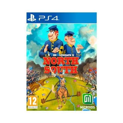
The Bluecoats North vs. South

0
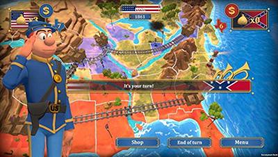
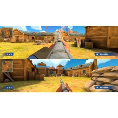
De beurt van de speler is als volgt verdeeldDe trein gaat van fort naar fort en draagt goud, wat overeenkomt met de huidige goudstapel van de speler.Als een vijandelijk bataljon op het treinpad staat, zal dit de fase van de treinaanval verdediging starten. Als de aanvaller de controle over de trein overneemt, wordt het goud aan hem toegekendStrateg...

Verkopers met dit product

Verkoper
Bezorging
Prijs
Nedgame.nl logo
Nedgame.nl
1 dag
3,99
18,-

Anderen bekeken ook

-55%
The Bluecoats North vs. South
De beurt van de speler is als volgt verdeeldDe trein gaat van fort naar fort en draagt goud, wat overeenkomt met de huidige goudstapel van de speler.Als een vijandelijk bataljon op het treinpad staat, zal dit de fase van de treinaanval verdediging starten. Als de aanvaller de controle over de trein overneemt, wordt het goud aan hem toegekendStrategische fase de speler verplaatst zijn eenheden op de vierkante kaart, kan nieuwe bataljons of strategische bonussen kopen in de winkel met goud ontvangen van gecontroleerde forten.Als een bataljon een door de vijand gecontroleerd gebied betreedt, zal het een gevechtsfase activeren.Als een bataljon probeert te verhuizen naar een gebied waar al een geallieerd bataljon staat, krijgt de speler de keuze om de twee samen te voegen, wat resulteert in een sterker bataljon.Gekochte bataljons kunnen op elk leeg geallieerd gebied worden geplaatstNieuw ingezette bataljons kunnen dezelfde beurt verplaatsen waarin ze zijn aangekomenEinde beurt de storm bewe…

39,99

18,-
Wegenkaart - landkaart Korea, North & South | ITMB
Een degelijke kaart met aanduidingen van o.a. nationale parken, vliegveld, benzinepomp en dirt-roads. Als overzichtskaart goed te gebruiken. Met Noord Korea, schaal 1:830.000, aan een kant en op de andere zijde Zuid Korea, schaal 1:550.000. This is a brand new title for ITMB, combining North and South Korea into one double-sided map focusing on the entire Korean Peninsula rather than its political components. The peninsula is undergoing a lot of change at the moment, and no one knows the ultimate outcome. North Korea seems interested in opening itself somewhat to South Koreans, and even if steps to date seem like baby ones, tensions between north and south seem cordial at the moment. For the time being, this map replaces our separate map of North Korea, as changing conditions makes it too risky for us to re-do our North Korea title until its future path is clearer. However, although this map also shows South Korea in good detail, we will continue marketing our Seoul and South Korea ma…
13,95
Wandelgids Cyprus - South & North | Rother Bergverlag
Uitstekende wandelgids met een groot aantal dagtochten. Met praktische informatie en beperkt kaartmateriaal! Wandelingen in verschillende zwaarte weergegeven in rood/blauw/zwart. 192 pages, 122 photos, 50 maps in 1:25,000, 1:50,000 and 1:75,000, overview maps to a scale of 1:400,000 and 1:900,000 Cyprus is not only famous for its cultural heritage and 9000 year old past – »Aphrodite’s Island« is one of the most popular hiking destinations in the eastern Mediterranean. The centre of the island is dominated by the Troodos mountain measuring some 2000 m in height, which despite its considerable altitude is more reminiscent of European low mountains, due to its softly rounded and forested peak. This Rother hiking guide proposes 50 routes mostly ranging from easy to medium level. Next to mountain tours, it also includes a selection of coastal paths along bizarre cliffs and adventurous ravine tours. Forest paths and nature trails lead through aromatic cedar woods, silent valleys and to remo…
17,50
Wegenkaart - landkaart North East New South Wales | Hema Maps
Detailkaart van een deel van Australië. Zeer goed leesbaar, met naast de topografische details veel symbolen waarmee allerhande toeristische zaken worden aangeduid als campsites, nationale parken, attracties, wandelmogelijkheden etc. The map covers the east coast from just south of Coffs Harbour north to Brisbane and west to Inverell. Extensive tourist information and photographs are provided on the area, every point of interest highlighted, and a matrix details all of the facilities available in the National Parks. Detailed road map of the coastal area from Coffs Harbour to Brisbane, extending inland across the Great Dividing Range to beyond the New England Highway. Topography is shown by relief shading with names of mountain ranges and selected peaks. National parks, reserves, and state forests highlighted. Symbols indicate campsites and caravan parks, 24hour fuel supplies, information centres, places of interest, etc. Numerous wineries are highlighted, particularly around Stanthorp…
17,50
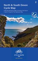
Fietskaart 02 Cycle Maps UK North and South Devon | Cordee
Een nieuwe fietskaarten serie van Groot-Brittannië. Gedrukt op scheur- en watervast papier en mooi handzaam klein formaat. Deze kaarten zijn met name heel goed om de Lange Afstands Fietsroutes (LF) te fietsen, het National Cycle Network staat duideljk ingetekend. Daarnaast vind je op de kaart veel praktische informatie als fietsenmakers, campings, jeugdherbergen en supermarkt.  Map 2 covers North and South Devon, including Dartmoor and the western part of Exmoor National Parks. The Devon coast to Coast route from Ilfracombe to Plymouth is fully covered.   The maps are all produced at a scale of 1:100 000 showing important features including the National cycle Network. Sections on road, off road and traffic free are all shown in differing colours along with their route number. Other roads and their classification are shown enabling you to link rides or explore sections and discover new routes at home or further afield.   Facilities such as toilets, pubs, accommodation, bike shops, repa…
12,95
Wegenkaart - landkaart Explorer Map Mid North Coast, New South Wales | Hema Maps
Detailkaart van een deel van Australië. Zeer goed leesbaar, met naast de topografische details veel symbolen waarmee allerhande toeristische zaken worden aangeduid als campsites, nationale parken, attracties, wandelmogelijkheden etc. A regional map of the Mid North Coast of New South Wales (1:350,000) that ranges from Northern Newcastle, west to Mudgee, as far as Gunnedah in the North and East to Port Macquarie. Covered regions in the map include; Gunnedah, Tamworth, Mudgee, Port Macquarie, Maitland, Kempsey, Taree, and Forster. Also includes the following National Parks; Barrington Tops NP, Oxley Wild Rivers NP, Hat Head NP, Carrai NP, Werrikimbe NP, Cottan-Bimbang NP, Mummel Gulf NP, Nowendoc NP, Curracabundi NP, Wollemi NP, Goulburn River NP, Yengo NP, and Towarri NP. On the opposite side is a detailed inset map of the Barrington Tops National Park (at 1:100,000 scale) plus extensive information on numerous regions, including visitor, historical and background information.
17,50
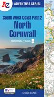
Wandelatlas 2 Adventure Atlas South West Coast Path North Cornwall | A-Z Map Company
AZ heeft de meest gedetailleerde wandelkaarten van delen van het South West Coast Path  gebundeld in een atlasje. Daardoor is het heel handig qua formaat. De kaarten zelf zijn perfect voor het wandelen. Schaal 1:25.000 Plan your next adventure along the North Devon & Somerset section of the South West Coast Path with trusted mapping from A-Z The perfect companion for those who love the great outdoors, the A-Z Adventure Series features 1:25000 Ordnance Survey mapping in a convenient book, complete with index. The South West Coast Path is a National Trail along the Somerset, Devon, Cornwall and Dorset coasts. This stunning walk from Minehead, Somerset covers 630 miles to South Haven Point in Poole Harbour, passing through two World Heritage Sites (the Jurassic Coast and the Cornwall and West Devon Mining Landscape), Exmoor National Park, Land's End and many areas of outstanding natural beauty.   This guide to the North Devon and Somerset section features 36 pages of continuous Ordnan…
17,95
Wegenkaart - landkaart Zuid Korea - Noord Korea, North and South Korea | Reise Know-How Verlag
Tweetalige kaart (Engels en Duits). Door ingetekende lengte- en breedtegraden is het gebruik van GPS mogelijk. Met hoogtelijnen en uitgebreid wegennetwerk: daarnaast worden ook de afstanden tussen belangrijke plaatsen duidelijk leesbaar weergegeven. Het kleurgebruik is zodanig dat je een goede indruk krijgt van hoogteverschillen en soorten landschap. Natuurlijk staan de toeristische bezienswaardigheden duidelijk vermeld.   Gedrukt op water- en scheurvast papier! Polyart is een synthetisch product vrij van giftige stoffen dus duurzaam. Het papier gaat echt lang mee.   Hochreißfeste und 100% wasserfeste Landkarte „Korea, Nord und Süd“ aus der Serie world mapping project.   Reise Know-How Landkarten zeichnen sich durch besonders stabiles Kunststoffpapier aus, das beschreibbar ist wie Papier, sogar mit Bleistift. Der Pappumschlag ist abnehmbar, so dass sich die Karte bequem in jede Tasche stecken lässt. Eine Schutzhülle ist nicht erforderlich. Die kartografische Darstellung konzentrier…
16,95
Wandelatlas 1 Adventure Atlas South West Coast Path North Devon & Somerset | A-Z Map Company
AZ heeft de meest gedetailleerde wandelkaarten van delen van het South West Coast Path  gebundeld in een atlasje. Daardoor is het heel handig qua formaat. De kaarten zelf zijn perfect voor het wandelen. Schaal 1:25.000 Plan your next adventure along the North Devon & Somerset section of the South West Coast Path with trusted mapping from A-Z The perfect companion for those who love the great outdoors, the A-Z Adventure Series features 1:25000 Ordnance Survey mapping in a convenient book, complete with index. The South West Coast Path is a National Trail along the Somerset, Devon, Cornwall and Dorset coasts. This stunning walk from Minehead, Somerset covers 630 miles to South Haven Point in Poole Harbour, passing through two World Heritage Sites (the Jurassic Coast and the Cornwall and West Devon Mining Landscape), Exmoor National Park, Land's End and many areas of outstanding natural beauty.   This guide to the North Devon and Somerset section features 36 pages of continuous Ordnan…
17,95
Wegenkaart - landkaart 2 USA . Noord: Idaho - Montana - Wyoming - North Dakota - South Dakota - Nebraska | Reise Know-How Verlag
Tweetalige kaart (Engels en Duits). Door ingetekende lengte- en breedtegraden is het gebruik van GPS mogelijk. Met hoogtelijnen en uitgebreid wegennetwerk: daarnaast worden ook de afstanden tussen belangrijke plaatsen duidelijk leesbaar weergegeven. Het kleurgebruik is zodanig dat je een goede indruk krijgt van hoogteverschillen en soorten landschap. Natuurlijk staan de toeristische bezienswaardigheden duidelijk vermeld.   Gedrukt op water- en scheurvast papier! Polyart is een synthetisch product vrij van giftige stoffen dus duurzaam. Het papier gaat echt lang mee.   Topography is indicated by altitude colouring with numerous spot heights and names of mountain ranges and passes. Salt lakes, swamps, seasonal rivers and glacier are also shown. Detailed presentation of the road network includes minor roads and tracks and railways are also shown.   Internal administrative units are presented with their boundaries and names. National parks and other protected areas are highlighted. A wide …
13,95

Klanten-reviews van The Bluecoats North vs. South

Er zijn nog geen beoordelingen voor dit productBen jij de eerste die een review plaatst?

Meer over The Bluecoats North vs. South

Productomschrijving

De beurt van de speler is als volgt verdeeldDe trein gaat van fort naar fort en draagt goud, wat overeenkomt met de huidige goudstapel van de speler.Als een vijandelijk bataljon op het treinpad staat, zal dit de fase van de treinaanval verdediging starten. Als de aanvaller de controle over de trein overneemt, wordt het goud aan hem toegekendStrategische fase de speler verplaatst zijn eenheden op de vierkante kaart, kan nieuwe bataljons of strategische bonussen kopen in de winkel met goud ontvangen van gecontroleerde forten.Als een bataljon een door de vijand gecontroleerd gebied betreedt, zal het een gevechtsfase activeren.Als een bataljon probeert te verhuizen naar een gebied waar al een geallieerd bataljon staat, krijgt de speler de keuze om de twee samen te voegen, wat resulteert in een sterker bataljon.Gekochte bataljons kunnen op elk leeg geallieerd gebied worden geplaatstNieuw ingezette bataljons kunnen dezelfde beurt verplaatsen waarin ze zijn aangekomenEinde beurt de storm beweegt. Waarschijnlijkheid dat Native American Mexicanen een bataljon aanvallen.Gevechtsfase Unie en zuidelijke legers botsen in een realtime strijd. Elke kant gebruikt dezelfde eenheden- 1 infanterieploeg- 1 cavalerieploeg- 2 kanonploegen- De strijd eindigt wanneer een leger is vernietigd of zich heeft teruggetrokken van het slagveld.- De winnaar van de strijd verkrijgt behoudt de controle over de aangevallen staat.Forten aanvallen verdedigingenDe spelers moeten vijanden uitschakelen om de controle over het fort te grijpen of te behouden. Deze fase wordt gespeeld in FPS-weergave.Train aanvallen verdedigingenDe spelers moeten vijanden uitschakelen om de trein te grijpen of te behouden. Deze fase wordt gespeeld in FPS-weergave. In de aanvalsmodus moet de speler vooruitgang boeken op het dak van de trein.

Productinformatie

    Productspecificaties

    Artikelnummer(s)
    EAN
    3760156485942
    Brand
    Mindscape

    Verken gerelateerde categorieën

    Webshop.nl maakt gebruik van cookies. Ga je verder op onze website, ga dan akkoord met het plaatsen van cookies en de verwerking van deze data door ons en vermelde partners.