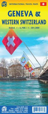
Stadsplattegrond - Wegenkaart - landkaart Genève & Westelijk Zwitserland | ITMB

0

Verkopers met dit product

Verkoper
Bezorging
Prijs
DeZwerver.nl logo
DeZwerver.nl
2,95
12,95

Anderen bekeken ook

Wegenkaart - landkaart - Stadsplattegrond Hongarije - Boedapest | ITMB
Central Europe emergence from Soviet Russia control has revealed one of the historic gems of Europe. It is difficult to think of Hungary without including Budapest, and the Danube River. This updated edition of Hungary shows the entire country on one side, with Budapest filling the other. This is the perfect map for a trip to the heart of Europe. The map has also been upgraded to plastic paper for durability. With this map, a traveller would not need another map to explore beautiful Hungary   Legend Includes: Road by classification, Major road, Tram, Long distance train, Ferry dock, Church, Post office, Point of interest, Police station, Shopping centre, Pedestrian zone and much more...
13,95
Stadsplattegrond - Wegenkaart - landkaart Cardiff & Wales | ITMB
Een dubbelzijdige kaart met aan de ene zijde een plattegrond van Cardiff, schaal 1:8.000 en op de andere zijde een wegenkaart, schaal 1:300.000, met aanduidingen van o.a. nationale parken, vliegveld, benzinepompen. ITMB finds the UK to be a never-ending source of maps needing to be prepared, such as this one of Cardiff and Wales. Cardiff is the capital of Wales, and is also an international access point to the UK; a map seems desirable. The city is based at the mouth of the River Taff, with most touristic points being concentrated in the harbour area, the city centre, and a concentration of eateries along Albany Road. Cardiff is shaped by two parallel motorways; the A4232close to the waterfront, and the A48 near the northern extremities. Both are included in our map, which also shows historic sites, hotels, and tourist amenities. The reverse side shows all of Wales as an entity, showing roads, rail lines, ferry crossing points, and access routes to England. It also shows historic site…
13,95
Wegenkaart - landkaart - Stadsplattegrond Kyoto & Japan West | ITMB
Dubbelzijdige kaart met aan de ene kant een plattegrond, 1 op 12.500, van Kyoto. Aan de andere kant een degelijke kaart met aanduidingen van o.a. nationale parken, vliegveld, benzinepomp en bezienswaardigheden van West Japan. Als overzichtskaart goed te gebruiken.   We are very pleased to see another updated edition of this very popular part of Japan coming out. Kyoto itself is rich in cultural heritage and has an excellent transit system for getting around. Regardless, one really needs a good map to find the temples and shrines. The map also includes an excellent inset map of Nara, a smaller city with an even greater concentration of temples and historic buildings. It is, however, the other side of the map, covering the western part of Japan that is the real value of this map. Stretching from Nagoya in the east past Kyoto and Osaka to Hiroshima and on to Fukuoka, this regional map is at an excellent scale to enable travellers to find their way around easily. All rail lines are includ…
13,95
Wegenkaart - landkaart - Stadsplattegrond Reykjavik & Iceland Southwest | ITMB
Een dubbelzijdige kaart met aan de ene kant een plattegrond van Reykjavík, schaal 1:10.000. Aan de andere zijde een overzichtskaart van zuidwest Ijsland, schaal 1:330.000, met aanduidingen van o.a. nationale parken, vliegveld, benzinepomp, dirt-roads.  Stads- en regiokaart van Reykjavik en Zuidwest-IJsland Met trots kondigen wij een gloednieuwe kaarttitel van ITMB aan: Reykjavik en Zuidwest-IJsland. Reykjavik, de hoofdstad van IJsland, is een fascinerende bestemming op zich. Op deze gedetailleerde stadskaart is Reykjavik op de voorzijde van het blad afgebeeld, inclusief het internationale vliegveld – de belangrijkste toegangspoort tot IJsland – en een uitgebreid overzicht van hotels. Dat is geen overbodige luxe, gezien het bloeiende toerisme in het land.   Het stadscentrum is helder in kaart gebracht, met een schaal die het mogelijk maakt de plattegrond te voorzien van het ‘footprint’-overzicht van alle gebouwen. Ook bevat de kaart een overzicht van de belangrijkste bezienswaardighede…
13,95
Stadsplattegrond - Wegenkaart - landkaart Quito & Ecuador Central | ITMB
Een degelijke wegenkaart van Ecuador met aanduidingen van o.a. nationale parken, vliegveld, benzinepomp, dirt-roads en kleine plattegrond van hoofdstad. Als overzichtskaart goed te gebruiken. Finally, ITMB releases its long-awaited re-worked map of the wonderful South America city of Quito. The city is squeezed in between mountain ranges and, the entire city stretches from north (on the right-hand side of the map) to the south. The "bottom" of the map is, actually the eastern portion. A regional inset map clarifies the situation. The street network is clearly shown, along with the rapid line bus way and the city's Metro. The Old Town is perhaps the most interesting portion of the city for visitors and is on the left-hand portion of the map. The newer downtown is centered on La Carolina Park on the right-hand side of the map. This is where most of the shopping malls and hotels are located. The old airport is shown in part on the far right, but the new international airport is located f…
13,95
Wegenkaart - landkaart - Stadsplattegrond China South - Zuid | ITMB
Een degelijke wegenkaart met aanduidingen van o.a. nationale parken, vliegveld, benzinepomp, dirt-roads. Als overzichtskaart goed te gebruiken.   China is a very large country. While our map of the entire country is fine for general travel and sells well, China is too large to show areas in detail. This map concentrates on the part of China from Shanghai south and all the way west to Lhasa and includes Taiwan and Hainan Island. We are not trying to make any sort of political comment here, but geographically, both Tibet and Taiwan fall within the area of coverage and are both included for this reason alone. The map also includes insets of Hong Kong, Guangzhou and Shanghai   Legend Includes: Roads by classification, Points of Interest, National Parks, Airports, Golf Courses, Beaches, Campsites, Waterfalls, Viewpoints, Churches, Surfing/Scuba Diving Spots, Fishing Spots, Hospitals, harbours/Ports, Lighthouses, Museums, Monuments, Caves, Mosques, Mountain Peaks, Botanic Gardens, Wildlife …
13,95
Wegenkaart - landkaart - Stadsplattegrond Hong Kong & Region | ITMB
Plattegrond van Hong Kong met aan de ene kant Hong Kong op een schaal van 1:10.000 en op de achterkant de omgeving op een schaal van 1:60.000. De kaart is uitgevoerd met register en metrokaart. De kaart beslaat Hongkong tot aan Sham Shui Po, Ngau Tai Kok, Vitoria Peak  en Quarry Bay. De regiokaart gaat tot aan Shenzhen. Op deze kaart staan diverse campings en ook bushaltes, treinlijnen en de ferry's.   Legend Includes: Roads by classification, Points of Interest, Castles, Museums, Cathedrals, Churches, Abbeys, Theme Parks, Airports, Airstrips, Caravan Camps, Motorway Service Stations, Caves, Viewpoints, Zoos, Golf Courses, Lighthouses, National Parks, Rivers, Lakes, Waterfalls, Mountain Peaks, Ruins, Camping Sites, Tourist Information Centres, Skiing, Wildlife Reservation, and much more.
13,95

Klanten-reviews van Stadsplattegrond - Wegenkaart - landkaart Genève & Westelijk Zwitserland | ITMB

Er zijn nog geen beoordelingen voor dit productBen jij de eerste die een review plaatst?

Meer over Stadsplattegrond - Wegenkaart - landkaart Genève & Westelijk Zwitserland | ITMB

Productinformatie

    Verken gerelateerde categorieën

    Webshop.nl maakt gebruik van cookies. Ga je verder op onze website, ga dan akkoord met het plaatsen van cookies en de verwerking van deze data door ons en vermelde partners.