Stadsplattegrond - Wegenkaart - landkaart Dubrovnik & Croatian Coast Cruise | ITMB

0
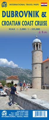
Goede plattegrond van Dubrovnik, schaal 1:3.000. Met aan de achterzijde een wegenkaart, schaal 1:325.000, met als extra informatie routes van veerboten en cruiseschepen ingetekend.   The ancient port city of Dubrovnik, on the southern Croatian coastline, has evolved into a major tourist destination. The old walled city, normally entered through th...

Verkopers met dit product

Verkoper
Bezorging
Prijs
DeZwerver.nl logo
DeZwerver.nl
2,95
13,95

Anderen bekeken ook

Wegenkaart - landkaart Tahiti - French Polynesia | ITMB
Anyone who has visited Tahiti retains fond memories of a wonderful Polynesian paradise. This map shows the major islands of French Polynesia as a series of large insets on Side 1. An overall inset map showing the many islands is also shown, but for showing detail, one must expand the individual islands. The largest one is the volcanic Tahiti Nui, with the capital city of Pape’ete (or Papeete in English), for which a detailed inset map is included. Most visitors stay in the vicinity of Papeete, along the coast. We show several popular resorts. There is a good circular road around the island’s shoreline, but no roads in the interior. The island is joined to another, called Tahiti Iti, or Little Tahiti, and roads extend partway around this less-developed part of the combined island. Most of the other islands are rarely visited, although they have resorts, beaches, and a lifestyle of their own. Names like Huahine, Riatea, Tahaa, and Maiao may not be as familiar as they should be, but all …
14,95
Nieuw
Wegenkaart - landkaart Slovenie - Slovenia & Croatian coast | ITMB
ITMB have visited Slovenia several times and find it to be an interesting and scenic part of Europe with modern and well-maintained hotels, restaurants and roads, with prices being much more affordable than in neighbouring countries to the west. As the country is not particularly large, we have limited our country coverage to one side of the sheet, with a detailed inset map of Ljubljana. The other side is a lovely map of the Dalmatian Coast. Now that Croatia is part of the EU, border limitations with the rest of western Europe have been removed and driving from Italy or Slovenia southward towards Dubrovnik is easy. The map shows the Pula Peninsula, the coastal islands of Cres, Brac, and Havar, and resort communities such as Zadar, Split, and medieval Dubrovnik. The new coastal motorway is mostly complete, but political difficulties are forcing an expensive tunneling project to by-pass part of Bosnia. Once completed, the highway will stretch to the Montenegrin border and become a major…
13,95
Nieuw
Wegenkaart - landkaart Mauritania & Mali | ITMB
Een degelijke kaart met aanduidingen van o.a. nationale parken, vliegveld, benzinepomp, dirt-roads en kleine plattegrond van hoofdstad. Als overzichtskaart goed te gebruiken. Mali 1:1.900.000 Mauretanië 1:2.200.000 In this edition, we have combined Mauritania with Mali. Although both are interesting countries, the two fit naturally together as a unit, albeit at slightly differing scales. Technically, this should be a 1st edition map, as it is the first time we have combined these two desert countries on to one sheet, but I ll let Robert at the Library of Congress worry about the niceties of bibliographic accuracy as soon as Trump allows him to do the work he loves for a salary. Mauritania was one of the most unusual countries I visited as a young traveller. Of course, I had an advantage, in that I was too young to know that what I was doing was supposed to be impossible. I entered from what was then the Spanish Sahara via a piste (a sandy track with multiple pathways, only some of whi…
13,95
Wegenkaart - landkaart Southern Alberta & Southern British Columbia | ITMB
ITMB, being based in Vancouver, BC, understandably has a local/regional market for our map line. We have a map of Western Canada, as well as an atlas, a very nice map of BC itself, a map of the south half of BC, and a map of part of BC combined with Washington State. What we did not have, until now, was a map covering the most touristically-visited part of all of Canada – namely, the southern halves of both British Columbia and its neighbour, Alberta, with a small amount of Washington State, Idaho, and Montana (to assist those heading north and needing to know about border crossings). Therefore, ITMB is pleased to announce the release of Southern BC and Alberta. Side One covers BC from the US border (with a carry-on to Seattle) north to Prince George and east to the Alberta border, with a carry-on to Calgary. All of Vancouver Island, the Okanagan Valley, and the Rock Mountain National Parks of Banff and Jasper, are included. The map is rich with wilderness campsite (almost 1,000 are s…
13,95
Nieuw
Wegenkaart - landkaart Tel Aviv - Jaffa en Centraal Israel | ITMB
Een kaart die naast het wegennet en plaatsen ook de nadruk legt op de natuurkundige aspecten van het land of gebied. Met kleur worden de verschillende hoogtelagen weergegeven, waardoor je een mooi beeld krijgt van het land. Met symbolen worden bijvoorbeeld benzinepompen aangeduid maar ook stranden. Grote plattegrond Tel Aviv op schaal 1:12.000 Op andere zijde kaart van Centraal Israel op schaal 1:220.000 This map resulted from our visit to Israel a couple of years ago. We got lost in Tel Aviv and wasted a lot of time trying to find our way to where we were staying. Although quite good maps of Tel Aviv exist, most are in Hebrew and are very "Israeli". We decided to do a map that combined the newish city of Tel Aviv with its older and more exotic neighbour, Jaffa, which is currently dominated by those of a non-Jewish orientation. Jaffa is the ancient port used by Phoenicians, Greeks, Romans, and traders plying the Silk Road to China. Its old town is quite compact and a treat to explore.…
13,95
Wegenkaart - landkaart - Stadsplattegrond Toronto & Southern Ontario - Ontario zuid | ITMB
Overzichtskaart van het zuiden van Ontario - schaal 1:600.000 - met op de andere kant een grote plattegrond van Toronto op schaal 1:12.000 Legend Includes: Roads by classification, Accomodations, Museum, Churches, Buildings, Points of tourist, Public Interests, Post Offices, Police Stations, Schools, Live Theatres, Cinemas, Ruins, Bus Terminals, Ferry Terminals, Service Areas, Hospitals, Ports, Mines, RCMP, Major Airports, Secondary Airports, Camp Grounds, National Park and Equivalent Reserves, Ski, Picnic Sites, and much more.   Toronto is the largest city in Canada by far. Touristically, its attraction rests with its central core, from High Park in the west to the Don River in the east, and from the park-like islands in Lake Ontario to Bloor Street in the north. In this area, one finds remnants of the oldest portion of ‘muddy York’, the original fort built to deter American raiders (close to the exhibition grounds), Campbell House (at Queen & University), and the first public schoo…
13,95
Nieuw
Wegenkaart - landkaart Mexico Gulf Coast | ITMB
Een degelijke kaart met aanduidingen van o.a. nationale parken, vliegveld, benzinepomp, dirt-roads. Als overzichtskaart goed te gebruiken. Mexico is an ever-popular travel destination. The country is so large that we started mapping it as a series of regional maps years ago. The Gulf Cost extends from Brownsville, Texas through Vera Cruz to the Yucatan Peninsula. Due to the shape of the region, all of Belize and about half of Guatemala is included, but the focus is on the many attractions of the eastern Gulf coast of Mexico. Side 1 cover the northern coastal regions, going inland as far as Monterrey, Zacatecas, Morelia, and Mexico City. Side 2 shows the Gulf Coast from Tampico to Carmen, then on to Merida, Cancun, and the southern tip of Belize. By the shape of this part of Mexico, the Pacific Coast, from the Guatemalan border westwards past Acapulco is also shown. All major roads are shown, but as passenger rail service was discontinued several years ago, we have opted to not show mo…
13,95
Nieuw
Wegenkaart - landkaart Bosnië en Montenegro | ITMB
For some reason, Bosnia Herzegovina has never attracted the attention of firms publishing maps. Understandably, since the breakup of Yugoslavia, the entire region has been somewhat unattractive for visitors. Also, Bosnia by itself is difficult to map, due to its shape. However, we have visited the country several times and find it to be interesting, friendly, and attractive. We were particularly impressed by Montenegro. Since it broke away from Serbia, this country has moved forward quickly. It uses the Euro as a currency, has lovely Mediterranean Sea resorts along its coast, and is a progressive country tying its future to the rest of Europe as a future EU member. The roads in both countries are good, and the damage done by civil in-fighting largely a thing of the past. Both countries are well-worth a visit. The map also includes Kosovo. Ethnically, it is probably more tied to Albania than to Bosnia, but geographically, Bosnia is closer and Kosovo is shown in good detail on this doub…
13,95
Nieuw
Wegenkaart - landkaart Alaska's Inside Passage | ITMB
Een degelijke kaart met aanduidingen van o.a. nationale parken, vliegveld, benzinepomp, dirt-roads en kleine plattegronden van Anchorage, Seattle, Vancouver en Victoria. Als overzichtskaart goed te gebruiken.    We recently released our USA Pacific Coast Map, covering the segment between San Diego and Vancouver. This map completes the mapping of the Pacific Ocean coastline by mapping the routes followed by cruise ships and Alaska Ferries heading north from Seattle and Vancouver to Alaska. This is a double-sided map, with Vancouver Island and the coastline as far north as Prince Rupert on one side (with inset maps of Seattle, Victoria, and Vancouver)on side 1, and the coastline north to Glacier Bay and an onward inset map to Anchorage (including an inset map of the city) on the second side. As the actual routes followed by the numerous cruise lines vary, we can't show their actual sailing routes, but they generally follow the coastline within viewing distance of either the mainland or …
13,95
Wegenkaart - landkaart New Caledonia & Oceania Cruising | ITMB
Aan de ene kant een degelijke kaart  van Nieuw Caledonië, schaal 1:530.000, met aanduidingen van o.a. nationale parken, vliegveld, benzinepomp, dirt-roads. As overzichtskaart goed te gebruiken. Aan de andere kant een overzicht van cruise routes in Oceanië, schaal 1:12.000.000 The South Pacific island complex known as New Caledonia, or Nouvelle Caledonie in French, consists of a main island and half a dozen smaller islands (collectively called the Loyalty Islands. It is an overseas possession of France and uses the Euro as its currency. It is located about halfway between Australia and Fiji and is south of Vanuatu. The main island is one of the larger land masses in the Pacific, with a reasonably well-developed road infrastructure linking the capital city of Naomea with other urban areas. There are resort hotels at various locations along the coastline, but this is a territory that one would have to regard as being adventuresome. Most of the attractions are concentrated in the vicinity…
13,95

Klanten-reviews van Stadsplattegrond - Wegenkaart - landkaart Dubrovnik & Croatian Coast Cruise | ITMB

Er zijn nog geen beoordelingen voor dit productBen jij de eerste die een review plaatst?

Meer over Stadsplattegrond - Wegenkaart - landkaart Dubrovnik & Croatian Coast Cruise | ITMB

Productomschrijving

Goede plattegrond van Dubrovnik, schaal 1:3.000. Met aan de achterzijde een wegenkaart, schaal 1:325.000, met als extra informatie routes van veerboten en cruiseschepen ingetekend.   The ancient port city of Dubrovnik, on the southern Croatian coastline, has evolved into a major tourist destination. The old walled city, normally entered through the famous Pile Gate, was so crowded with tourists when we arrived, that it took some time to get to the main street of Stradun. The city has completely recovered from the Montenegrin bombing during the breakup of Yugoslavia, with a few shellholes remaining just to show to tourists. The highlights of a visit are the Rector’s Palace, the Tvrdava fortress, and the cathedral. The map covers the urban area outside of the old town as well, as this is where most of the hotels and restaurants are located. The other side of the map shows the extensive coastline of Croatia in two parts – from the Italian border to Trogir, and from Split to the border with Montenegro. We travelled from Porec to Dubrovnik in a small cruise ship of 45 passengers, which enabled us to visit ports that larger ships could not reach. As a result, we visited islands we could not have otherwise visited. The cover picture shows grandson Johnny in one such small town.   Legend Includes: Roads by classification, Rivers and Lakes, National Park, Airports, Points of Interests, Highways, Main Roads, Zoos, Fishing, and much more...

Verken gerelateerde categorieën

Webshop.nl maakt gebruik van cookies. Ga je verder op onze website, ga dan akkoord met het plaatsen van cookies en de verwerking van deze data door ons en vermelde partners.