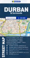
Stadsplattegrond Streetmap Durban | MapStudio

0
Duidelijke dubbelzijdige plattegrond van Durban en omliggende wijken met een uitgebreide index. Te vinden op de kaart zijn o.a. spoorlijnen + stations, hotels, campings, bezienswaardigheden en natuurreservaten. Detailed map of Durban at 1 : 25 000 scale; Kloof to Merewent; Durban CBD in detail; Indexed street & suburb names; index indicating new +...

Verkopers met dit product

Verkoper
Bezorging
Prijs
DeZwerver.nl logo
DeZwerver.nl
niet bekend
11,50

Anderen bekeken ook

Nieuw
Wegenkaart - landkaart - Stadsplattegrond Bloemfontein | MapStudio
Uitgebreide stadsplattegrond van Bloemfontein  en directe omgeving. The Bloemfontein Street Map is a 1st edition street map providing coverage of Bloemfontein and surrounds, plus includes the latest interchange layouts, names and route numbers. The main map is at a 1:25 000 street-level scale and includes a detailed Bloemfontein map.   The map features reserves, parks and fields; golf courses, sports fields and stadiums; retail areas and shopping malls; intersection layouts, route numbers and interchange names; places of interest, historic sites and hotels; suburb names with boundaries; schools and sporting venue locations; a detailed index booklet with all street names and suburbs; industrial areas; hospitals and clinic locations; police station locations; wine estates and heritage sites; traffic light positions; bird sanctuaries; detailed sport symbols for sport venues; parks and public open-areas; post office and library locations.   Coverage Extent: Batho, Brandwag, Fichardt Park,…
7,95
Nieuw
Stadsplattegrond Streetmap Cape Town - Kaapstad | MapStudio
Uitgebreide stadsplattegrond van Kaapstad en directe omgeving.    The Cape Town & Peninsula Street Map is the ideal travel companion to find your way around Cape Town.   Coverage includes:   North : Milnerton West : Hout Bay East : Jakes Gerwel (Vanguard Drive) South : Muizenberg   Great content which includes a detailed map of Cape Town CBD and Waterfront insert map.   The main map is in detailed 1: 25 000 street level scale, which depicts parks and reserves, golf courses, sports fields and stadiums, intersections, route numbers and interchange names. The map also includes places of interest, historical sites and hotels, suburb names and boundaries, schools and sporting venues, industrial areas, wine estates and heritage sites as well as bird sanctuaries and post offices and libaries.  
16,95
Nieuw
Stadsplattegrond Singapore | Freytag & Berndt
Stadsplattegrond met register. Helder kaartbeeld waarbij de naamgeving goed leesbaar is weergegeven. Met de toeristische bezienswaardigheden in symbolen weergeven: monumenten, musea, stadions e.a. Daarnaast handige zaken als postkantoren, parkeergarages en stations. Veelal ook met een openbaar vervoer of metro kaart als inzet This city map of Singapore at 1: 15,000 by Freytag & Berndt clearly shows tourists attractions, public transport and feature a small inset of central Singapore and a useful index at the back. The map covers an area which extends from the Queenstown New Town district in the west to the Bedok Reservoir in the east and from Bishan metro station and MacRitchie Reservoir Park in the north to the northern part of Sentosa island in the south. The roads network is clearly represented and shows the main motorways reaching the city as well as main and secondary roads and symbols locate the car parks around the city. Colourful lines and symbols illustrate metro lines and st…
13,95
Wegenkaart - landkaart Zuid-Afrika - South Africa, Lesotho & Swaziland | MapStudio
Duidelijke overzichtskaart van Zuid Afrika, Lesotho en Swaziland. Met gedetailleerde kaarten van de regio's Gauteng, Kaapse Schiereiland en Durban. South Africa Lesotho and Swaziland map is a  new edition which includes major and minor routes with route markers, tourist regions and has an index to place names.   Content includes places of interest, mountain passes, topography, national parks & reserves, historic sites, railway lines & stations, route numbers, distance table and the latest toll routes and all route classifications.   Coverage includes a detailed map of South Africa at a scale of 1 : 1 500 000 along with detailed area maps of Gauteng, Durban and Cape Peninsula.
16,95
Nieuw
Stadsplattegrond Buenos Aires - Argentinië Noordoost | ITMB
A double-sided road map of Buenos Aires and Northeast Argentina.   One side shows a detailed street map of Buenos Aires, with inset maps of subway lines, the Greater Buenos, and a place names index. This plan covers Downtown Buenos Aires, the Jorge Newbery airport, Ciudad Universitaria, and the central station.   Touristic information on the map include:  places of interest museums religious buildings parks cinemas hospitals, post-offices malls police stations   The other side shows Northern Argentina, from Buenos Aires to the south to the borders of Paraguay and Bolivia.    The legend is in English and in Spanish.
13,95
Nieuw
Wegenkaart - landkaart 01 Kaapstad - Cape Town and Surrounding Attractions | MapStudio
Het overzicht is soms misschien een beetje onduidelijk. maar de details in de inzetten en delen van de kaart zijn prima en voldoen goed voor het rondrijden met een eigen auto. Double-sided map, with a general road map on one side, plus numerous street plans and descriptions of four special routes on the reverse. The main map covers an area within reach as day trips from Cape Town, extending east to Swellendam and north to Langebaan. Road classification includes unsurfaced roads, intermediate driving distances on main and secondary roads, toll routes with gates, and mountain passes. Railways are shown with local stations. An impression of relief is provided by elevation tinting (perhaps somewhat confusing for regular map users - the higher the altitude, the greener the colour!), spot heights for main peaks, and names of mountain ranges. Nature and forest reserves, plus salt pans and marshes are indicated. Symbols mark local airfields, historical sites, caravan parks, many wine estates,…
16,95
Stadsplattegrond Pocket Street Map Cambridge | A-Z Map Company
Stadsplattegrond van Cambridge in 48 pagina´s, inclusief index met straatnamen en belangrijke plaatsen. Bevat tevens een detail weergave van het centrum.   Navigate your way around Cambridge with detailed street maps from A-Z This up-to-date, folded A-Z street map includes more than 2,000 streets in and around Norwich. As well as the Norwich Cathedral and central Norwich, the other areas covered include Cringleford, Lakenham, Whitlingham Country Park, Thorpe St Andrew, New Catton and Hellesdon. The large scale 1 mile to 5.5 inch (1 km to 8.68 cm) street map includes the following: • Places of interest • One-way streets and car parks • Index to streets, places of interest, place and area names, park and ride sites, national rail stations, hospitals and hospices The perfect reference map for finding your way around Norwich.  
7,95
Nieuw
Wegenkaart - landkaart Kuala Lumpur & Malay Peninsula | ITMB
Goede stadsplattegrond van Kuala Lumpur. Met register en suburban treinsysteem. De echt verre buitenwijken van deze megastad staan er niet op. Aan de achterzijde een overzichtskaart van het vasteland van Maleisië met een schaal van 730.000 Street map of Kuala Lumpur at 1:10,000 covering the city from the Sentul Terminal and the Setapak Park in the north to the Chinese Cemetery in the south, and from the Parliament House (Bangunan Paliament) in the west to the Royal Selangor Golf Club in the east. TDetail includes markets, notable and public buildings, shopping malls, various religious buidings, accommodation, museums, theatres and cinemas, points of interest, post offices and police stations, bus terminals. Various railway systems and pedestrian roads are also indicated alongside land use, e.g. parks, markets, industrial areas, attractions, etc. Includes an extensive index of place names.  
13,95
Nieuw
Wegenatlas IJsland met stadsplattegronden | Ferdakort
Super handige kleine wegenatlas van IJsland (schaal 1:500.000) met vooral een enorme hoeveelheid plattegronden van steden en dorpen, enkele themakaarten en een groot register. De kaarten zijn uitstekend leesbaar en de atlas in in een mooie ringband uitgevoerd.  Road Atlas of Iceland at 1:500,000 from Ferðakort, published in a handy 15x25cm spiral-bound format, with an index of over 3,000 entries, a comprehensive distance table, 46 street plans including Reykjavik and several thematic map sincluding cultural heritage and geology.   The whole of Iceland is covered at 1:500,000 with the road network distinguishing between paved and gravel roads, and showing which small local roads are maintained by the country’s government. Fords, locations of petrol stations, driving distances and car ferry routes are marked. National parks and other protected areas are highlighted and symbols mark locations of various places of interest: different types of tourist accommodations including campsites, re…
30,95
Nieuw
Stadsplattegrond Jakarta | Freytag & Berndt
Stadsplattegrond met register. Helder kaartbeeld waarbij de naamgeving goed leesbaar is weergegeven. Met de toeristische bezienswaardigheden in symbolen weergeven: monumenten, musea, stadions e.a. Daarnaast handige zaken als postkantoren, parkeergarages en stations. Veelal ook met een openbaar vervoer of metro kaart als inzet Main through routes are highlighted; the number of smaller streets with names varies from district to district. Public buildings are prominently marked and most are also named, and colouring indicates industrial areas. Symbols highlight locations of selected hotels, museums, shopping centres, car parks, bus terminals, golf courses, hospitals, etc. as well as numerous mosques and other religious buildings. Map legend includes English. Extensive street index is on the reverse of the map.  
13,95

Klanten-reviews van Stadsplattegrond Streetmap Durban | MapStudio

Er zijn nog geen beoordelingen voor dit productBen jij de eerste die een review plaatst?

Meer over Stadsplattegrond Streetmap Durban | MapStudio

Productomschrijving

Duidelijke dubbelzijdige plattegrond van Durban en omliggende wijken met een uitgebreide index. Te vinden op de kaart zijn o.a. spoorlijnen + stations, hotels, campings, bezienswaardigheden en natuurreservaten.

Detailed map of Durban at 1 : 25 000 scale; Kloof to Merewent; Durban CBD in detail; Indexed street & suburb names; index indicating new + old street names; main routes with route numbers, freeways & interchanges; schools; sports fields; hospitals / clinics & municipal clinics; shopping malls; police stations & fire departments; parks & Reserves; industrial areas; places of interest; historical monuments; provincial heritage sites; museums/art galleries; includes Moses Mabhida soccer stadium position.


Verken gerelateerde categorieën

Webshop.nl maakt gebruik van cookies. Ga je verder op onze website, ga dan akkoord met het plaatsen van cookies en de verwerking van deze data door ons en vermelde partners.