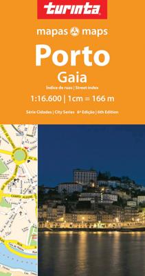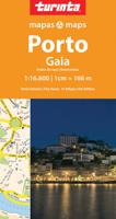
Stadsplattegrond Porto | Turinta

0
Folded paper street map of Porto/Gaia. Features a comprehensive street name index on the reverse of the map, along with a small map to indicate the main road and railway routes linking Porto with neighbouring cities....

Verkopers met dit product

Verkoper
Bezorging
Prijs
DeZwerver.nl logo
DeZwerver.nl
2,95
11,50

Anderen bekeken ook

Reisgids Rough Guide Pocket Porto | Rough Guides
Een kleinere versie in zakformaat van de grotere versies van de Rough Guides. Als altijd weer vol met goede informatie over cultuur en praktische zaken. Achterin een kaart van de stad. This compact, pocket-sized Porto travel guidebook is ideal for travellers on shorter trips and those trying to make the most of Porto. It's light, easily portable and comes equipped with a pull-out map.   This Porto guidebook covers: Ribeira, Baixa, Vila Nova de Gaia, The Sé, Aliados, Miragaia, Massarelos, Boavista, Vila do Conde.   Inside this Porto travel book you will find:   - Curated recommendations of places - main attractions, off-the-beaten-track adventures, child-friendly family activities, chilled-out breaks in popular tourist areas - Things not to miss in Porto - Ribeira, Palácio da Bolsa, Ponte de Dom Luís I, Vila Nova de Gaia's historic wine lodges, São Bento, Torre dos Clérigos, Boat ride under Porto's six bridges, Foz do Douro, Livraria Lello, Jardim do Palácio De Cristal, Casa da…
13,95
Nieuw
Stadsplattegrond City map Porto | Lonely Planet
De stadsplattegronden van Lonely Planet zijn uitgevoerd op scheur- en watervast papier, zijn lichtgewicht en kennen een handig formaat. Het centrum van de stad is in heldere kleuren in beeld gebracht met straatnamen, bezienswaardigheden en symbolen voor openbaar vervoer. Op de achterzijde staat informatie over de toeristische hoogtepunten en in de meeste gevallen een schematische plattegrond van het openbaar vervoer. Met een register. Durable and waterproof, with a handy slipcase and an easy-fold format, Lonely Planet's Porto City Map is your conveniently sized passport to travelling with ease. With this easy-to-use, full-colour navigation tool in your back pocket, you can truly get to the heart of Porto, so begin your journey now! Durable and waterproof Easy-fold format and convenient size Handy slipcase Full colour and easy to use Extensive street and site index Images and information about top city attractions Handy transport maps Walking tour routes Practical travel tips and dire…
10,95
Stadsplattegrond Streetwise Budapest | Michelin
REVISED 2023Streetwise Budapest Map is a laminated city center map of Budapest, Hungary. The accordion-fold pocket size travel map has an integrated metro map including lines & stations. Coverage includes:Main Budapest Map Front 1: 17,000Main Budapest Map Back 1:11,000Budapest City Center Map 1:11,000Millennium City Center Map 1:17,000Budapest Metro MapDimensions: 4" x 8.5" folded, 8.5" x 27" unfoldedPeople say Budapest is the Paris of Central Europe.   Maybe that statement is true because it combines a combination of western luxuries, architectural beauty, and cosmopolitan European traditions. But this baroque city is still connected to its Eastern European heritage with the steaming baths, incredibly complex language and lusty cuisine. Budapest straddles a curve in the river Danube which bisects two distinct parts.   The east side is known as Pest and the west side is known as Buda, hence Budapest. It's a very logical, well laid out city. Castle Hill is the premier destination for v…
9,95
Nieuw
Reisgids Pocket Porto | Lonely Planet
Pocket reisgidsen van Lonely Planet zijn een kleinere versie dan de 'echte' Planets. Vaak echter van bijzondere bestemmingen binnen een bepaald land waardoor er meer aandacht is en uitgebreidere tips zijn voor die bepaalde streek i.v.m. de grote Planets. Handzaam formaat, makkelijk in de binnenzak! Tcoh ook deze vol met praktische informatie. Discover twice the city in half the time as Lonely Planet's local travel experts reveal all you need to know to plan the ultimate short trip to Porto.   This latest edition uncovers the city's most popular experiences and unexpected surprises from chasing the waves with a surf lesson at Praia de Matosinhos, to hitting the historic cellars of Vila Nova de Gaia for a taste of barrel-aged port, and learning to paint your own tile with a workshop at Gazete Azulejos in Bonfirm.    Build a trip to remember with Lonely Planet's PocketPorto travel guide:   Our Pocket guidebook format contains the best insider knowledge for planning trips between…
14,95
Stadsplattegrond Fleximap Porto | Insight Guides
nsight Guides Flexi Map Porto   Travel made easy. Ask local experts. Designed for easy usage and durability, this map is all you need to explore Porto.   This easy to use, full-colour, waterproof map is all you need to navigate Porto. It also includes dotted highlight sights such as the Sé and Serralves, as well as essential information on getting around.   Features of this map to Porto:  - Detailed cartography: produced to the highest cartographic standards, highlighting all the main tourist sights, places to visit and transport networks - Informative text: useful travel information, essential facts about the destination, recommendations for the best places to see and tips for getting around - Easy to use: lightweight and wipe-clean in a handy pocket-size format. Sights linked to the mapping by numbered markers - Laminated finish: durable, weatherproof and easier to fold than conventional paper maps - Main map covering Porto city centre - Secondary map to cover excursions   You may a…
9,95
Fietskaart 09 Cycling guides Norfolk | Goldeneye
Norfolk is the fourth largest county in England and one of the most rural. It is also one of the flattest and our circular routes have been chosen to explore the quiet lanes linking the isolated and picturesque villages and places of interest. This is ideal cycling territory and fortunately, the Norfolk County Council (and its District Councils) are seriously committed in providing and developing cycling routes and in promoting a cycling culture that is sustainable and family friendly. Some of their routes are illustrated, hitherto.   The County has been described as flat (rather gentle undulations) and does not in fact rise much over 300 feet, but it offers great scenic interest; the dark forests of Breckland, the rolling chalk lands of the northwest, the unique watery patch of the Broads, and a coastline of great variety. Ancient churches and picturesque villages are there in abundance, the latter often decorated with the attractive signs designed by Harry Carter in the 1950’s.   Re…
14,95
Stadsplattegrond Pocket Street Map Liverpool | A-Z Map Company
Navigate your way around Liverpool with detailed street maps from A-Z This fully updated, folded map covers all of Central London, including: Regent's Park, King's Cross, The Barbican, Spitalfields, Tower Bridge, The South Bank, Waterloo Station, Westminster, South Kensington, Paddington Station and Lord's Cricket Ground.   The large scale 1 mile to 5.5 inch (1 km to 8.68 cm) street map includes the following:   • Places of interest   • One-way streets and car parks   • Index to streets, places of interest, place and area names, park and ride sites, national rail stations, hospitals and hospices   • Separate lists of streets, places of interest, cinemas, theatres and stations (which include London Underground, National Rail and Docklands Light Railway stations)   • A central London Underground Map is printed on the back cover.   The perfect reference map for finding your way around Central London.
7,95
Nieuw
Wegenkaart - landkaart - Stadsplattegrond Poland east - Warsaw, Oost Polen en Warschau | ITMB
ITMB wegenkaarten en wandelkaarten kenmerken zich door het kleurgebruik waarbij zo de nadruk wordt gelegd op de natuurkundige aspecten van het land of de streek. Het soort landschap en de hoogte worden hierdoor zeer duidelijk zichtbaar. Natuurlijk vind je ook de 'gewone' zaken als wegennet, spoorwegen, vliegvelden, ferrys, toeristische bezienswaardigheden en nationale parken er op terug.. Vaak - maar niet op alle kaarten - staat op de achterzijde een stadsplattegrond van hoofdstad of belangrijkste stad in de regio.  Voorzijde: Oost Polen shcaal 1:650.000 Achterzijde: Warschau, schaal 1:9.000 This is, at the same time, our second edition updated map of Warsaw and a brand new title for ITMB, in that we have added a regional map of the eastern half of Poland to the second side of the map. This gives the end user two maps for the price of one by combining the many attractions of the city with its surrounding countryside. Anyone with a small amount of historical knowledge knows that Warsaw…
13,95
Nieuw
Wegenkaart - landkaart 3315 Adventure Map Corsica | National Geographic
Wegenkaart van Corsica met vermelding van veel bezienswaardigheden, nationale parken en attrakties. Watervast en scheurvast. Juist door deze vermeldingen onderscheidt de kaart zich van andere wegenkaarten. National Geographic's Corsica Adventure Map is designed to meet the unique needs of adventure travelers with its durability and accurate information. Each folded map provides global travelers with the perfect combination of detail and perspective, highlighting the area’s terrain and best locations for adventure activities like snorkeling, surfing, fishing, and more. Adventure Maps include hundreds of points of interest that highlight diverse and unique destinations within the country.   The map includes the locations of thousands of cities and towns with a user-friendly index, plus a clearly marked road network complete with distances and designations for major highways, main roads, and tracks and trails for those seeking to explore more remote regions. The front side of the Corsica…
17,50

Klanten-reviews van Stadsplattegrond Porto | Turinta

Er zijn nog geen beoordelingen voor dit productBen jij de eerste die een review plaatst?

Meer over Stadsplattegrond Porto | Turinta

Productomschrijving

Folded paper street map of Porto/Gaia. Features a comprehensive street name index on the reverse of the map, along with a small map to indicate the main road and railway routes linking Porto with neighbouring cities.

Verken gerelateerde categorieën

Webshop.nl maakt gebruik van cookies. Ga je verder op onze website, ga dan akkoord met het plaatsen van cookies en de verwerking van deze data door ons en vermelde partners.