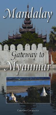
Stadsplattegrond Mandalay - Gateway to Myanmar | Odyssey

0
This is a double sided and illustrated, folded map sheet of 'Upper Myanmar' - including a detailed city map of Mandalay. The map sheet is more than just a map, heavily illustrated with 49 colour photos and it includes useful information for the traveller - both before and during a visit....

Verkopers met dit product

Verkoper
Bezorging
Prijs
DeZwerver.nl logo
DeZwerver.nl
2,95
14,95

Anderen bekeken ook

Wegenkaart - landkaart 3025 Adventure Map Myanmar - Birma | National Geographic
Mooie, heldere kaart van Myanmar, gedrukt op scheurvast en watervast papier.   National Geographic's Myanmar (Burma) Adventure Map is designed to meet the needs of adventure travelers with its durability and detailed, accurate information. This map includes the locations of cities and towns with a user-friendly index, a clearly marked road network complete with distances and designations for roads/highways, plus secondary routes for those seeking to explore off the beaten path. Adventure Maps differ from a traditional road map because of the specialty content they include. Each map contains hundreds of diverse and unique recreational, ecological, cultural, and historic destinations — outside of the major tourist hubs. National Geographic Adventure Maps are the perfect companion to a guidebook, yet far easier to pack!   Myanmar is a country with a varied landscape. From the highest peak, Hkakabo Razi, in the Hengduan Shan mountains on the border with China to the lowlands at the mouth …
17,50
Reisgids Myanmar - Burma | Lonely Planet
De perfecte reisgids voor zowel de georganiseerde als de zelfstandige reiziger. Naast een algemene inleiding van het land / streek vol met praktische informatie over hoe je er het beste kunt reizen: slapen, eten, vervoer, excursies ... alles kun je er in vinden. Engelstalig. Lonely Planet. It’s the dawn of a more democratic era in this extraordinary land, where the landscape is scattered with gilded pagodas and the traditional ways of Asia endure. Lonely Planet will get you to the heart of Myanmar, with amazing travel experiences and the best planning advice.   Lonely Planet Myanmar (Burma) is your passport to the most relevant, up-to-date advice on what to see and skip, and what hidden discoveries await you. Be dazzled by Buddhist architecture in Yangon, explore Bagan’s amazing plain of ancient temples, or hike to the floating gardens and markets of Inle Lake; all with your trusted travel companion. Get to the heart of Myanmar and begin your journey now!   Inside Lonely Planet Myanma…
23,95
Wegenkaart - landkaart Myanmar - Birma | Nelles Verlag
Goede overzichtskaart van Myanmar / Birma. Aan beide kanten bedrukt. Met veel toeristische aanduidingen als culturele bezienswaardigheden en nationale parken. Prima leesbare kaart en bovendien gedrukt op scheur-en watervast papier. Myanmar (Burma) at 1:1,500,000 from Nelles Verlag, with street plans of Yangon (Rangoon) and Mandalay, plus a plan of the World Heritage site at Bagan. The map is double-sided, with its smaller size offering a convenient format for use when travelling.    The country is divided north/south, with the panhandle shown as an inset on the southern side. Vivid relief shading with spot heights and names of mountain ranges presents the topography. National parks and/or protected area are indicated. Bagan 1 : 60.000 Mandalay 1 : 30.000 Yangon (Rangoon) 1 : 60.000
11,95
Reisgids Myanmar (Burma) | Insight Guides
Een rijk geillustreerde reisgids met diepgaande teksten: één van de beste reisgidsen die er bestaan. Eerste deel bestaat uit een beschrijving van de unieke aspecten van de regio, daarna een deel echte reisgids en als afsluiting een deel met praktische informatie. De uitstekende informatie wordt vergezeld van prachtige foto's en heldere kaarten. Niet alleen om mee te nemen, maar ook om vooraf en zelfs achteraf weer in de stemming te komen. With its glittering pagodas, timeless countryside and gracious people, Myanmar (Burma) is an extraordinarily beautiful destination which has been isolated from the rest of the world for decades. Finally, things are changing and tourism is set to explode in the coming years. This new edition of the Insight Guide Myanmar has been comprehensively overhauled to help inspire and inform, and guide you to the best that this little-known country has to offer. Following on from the inspirational Best Of Myanmar section, the country's rich past and cultural h…
22,50
Stadsplattegrond Athene | Anavasi
Handzame kleine plattegrond van Athene, op de achterkant een overizcht van de omgeving van de stad en een korte beschrijving van de belangrijkste bezienswaardigheden. Locations of the city’s 102 important archaeological sites, museums, and other important buildings, plus on the reverse a road map of the environs including the port at Piraeus and the international airport.   Coverage extends from south of the Acropolis and the Mousson Hill to beyond the central railway station and the National Archaeological Museum, and east well beyond the Lycabettus Hill. 102 locations – archaeological remains, museums, theatres, churches – are highlighted and listed with their addresses and contact details. The plan shows metro stations, and tram routes with line numbers.    On the reverse is a map of the city’s environs showing the road network with the metro and railway lines. Coverage includes the port Piraeus, the city’s international airport and Marathon. English language notes about important …
6,95
Wandelkaart Tour & Trail Formentera | Discovery Walking Guides
Goede, scheur- en watervaste, wandelkaart van Formentera.   Water-proof, split-proof, tear-proof, adventure-proof. Formentera Tour & Trail Super-Durable Map is simply the toughest, most accurate, easy to read, easy to use map of the island you can buy at any price. David & Ros Brawn surveyed this beautiful island in October 2015 carrying out their 'gps ground survey' pinpointing all the details needed to produce the definitive map of Formentera.   Large, 25k scale, easy to read map sheet includes a wealth of useful details. 20 metre and 100 metre contours combined with altitude shading bring the Formentera landscape to life. All of the legendary Tour & Trail attention to detail is included so that you will find those petrol stations, mirador viewpoints with parking, refreshment stops with parking and accurate road numbering that are so essential when adventuring by hire car; 'watts' new and unique to Formentera we have included the 'Electric hire car' recharging points making sure you…
15,95
Vogelgids a Naturalist's guide to the Birds of Myanmar | John Beaufoy
A Naturalist’s Guide to the Birds of Myanmar is an introductory photographic identification guide to 280 birds found in the most frequently visited parts of Myanmar, with a further 100 related species referred to in the descriptions. The selection covers widespread, endemic and near-endemic species, as well as species that are rare and threatened in other parts of Asia but significant in Myanmar.   High quality photographs from one of Myanmar’s top nature photographers are accompanied by detailed species descriptions, which include nomenclature, size, distribution, habits and habitat. The user-friendly introduction covers geography and climate, vegetation, opportunities for naturalists and the main sites for viewing the listed species. Also included is an all-important checklist of all of the birds of Myanmar encompassing, for each species, its common and scientific name as well as its vernacular name, its status in each state as well as its global IUCN status.   Thet Zaw Naing is a b…
18,50
Stadsplattegrond Streetwise Budapest | Michelin
REVISED 2023Streetwise Budapest Map is a laminated city center map of Budapest, Hungary. The accordion-fold pocket size travel map has an integrated metro map including lines & stations. Coverage includes:Main Budapest Map Front 1: 17,000Main Budapest Map Back 1:11,000Budapest City Center Map 1:11,000Millennium City Center Map 1:17,000Budapest Metro MapDimensions: 4" x 8.5" folded, 8.5" x 27" unfoldedPeople say Budapest is the Paris of Central Europe.   Maybe that statement is true because it combines a combination of western luxuries, architectural beauty, and cosmopolitan European traditions. But this baroque city is still connected to its Eastern European heritage with the steaming baths, incredibly complex language and lusty cuisine. Budapest straddles a curve in the river Danube which bisects two distinct parts.   The east side is known as Pest and the west side is known as Buda, hence Budapest. It's a very logical, well laid out city. Castle Hill is the premier destination for v…
9,95
Wandelkaart - Topografische kaart 747 Green Mountain National Forest North - Moosalamoo NRA - Rutland | National Geographic
Prachtige geplastificeerde kaart van het bekende nationaal park. Met alle recreatieve voorzieningen als campsites, maar ook met topografische details en wandelroutes ed. Door uitgekiend kleurgebruik zeer prettig in gebruik. Scheur en watervast! National Geographic's Green Mountain National Forest North Trails Illustrated topographic map is the most comprehensive available for outdoor enthusiasts of all types. Designed to be easy-to-read, yet highly detailed – this map includes a comprehensive road and trail network distinguishing between major, secondary and 4x4 roads, hiking, horse, biking, multi-use and non-motorized winter trails. All forest roads are labeled with their official road number and trails are clearly identified with their given name. Land management boundaries are color-coded showing National Forest, Ranger District, Wilderness Areas, Conservation Areas and more, plus the locations of private land within the Green Mountain National Forest. The renowned Appalachian Trai…
17,95
Wandelkaart - Topografische kaart 748 Green Mountain National Forest South - Robert T. Stafford White Rocks NRA - Manchester | National Geographic
Prachtige geplastificeerde kaart van het bekende nationaal park. Met alle recreatieve voorzieningen als campsites, maar ook met topografische details en wandelroutes ed. Door uitgekiend kleurgebruik zeer prettig in gebruik. Scheur en watervast! National Geographic's Green Mountain National Forest South Trails Illustrated topographic map is the most comprehensive available for outdoor enthusiasts of all types. Designed to be easy-to-read, yet highly detailed – this map includes a comprehensive road and trail network distinguishing between major, secondary and 4x4 roads, hiking, horse, biking, multi-use and non-motorized winter trails. All forest roads are labeled with their official road number and trails are clearly identified with their given name. Land management boundaries are color-coded showing National Forest, Ranger District, Wilderness Areas, Conservation Areas and more, plus the locations of private land within the Green Mountain National Forest. The renowned Appalachian Trai…
17,95

Klanten-reviews van Stadsplattegrond Mandalay - Gateway to Myanmar | Odyssey

Er zijn nog geen beoordelingen voor dit productBen jij de eerste die een review plaatst?

Meer over Stadsplattegrond Mandalay - Gateway to Myanmar | Odyssey

Productomschrijving

This is a double sided and illustrated, folded map sheet of 'Upper Myanmar' - including a detailed city map of Mandalay. The map sheet is more than just a map, heavily illustrated with 49 colour photos and it includes useful information for the traveller - both before and during a visit.

Productinformatie

    Verken gerelateerde categorieën

    Webshop.nl maakt gebruik van cookies. Ga je verder op onze website, ga dan akkoord met het plaatsen van cookies en de verwerking van deze data door ons en vermelde partners.