Stadsplattegrond Darwin en omgeving | Hema Maps

0
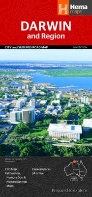
Stadsplattegrond van Darwin en de directe omgeving. Inclusief index. Offering maps of the region, suburbs and Darwin’s CBD. Containing the entire city with primary, secondary and tertiary road patterns, city centre distance markers on major roads and postcode and road numbering, these maps are easy and helpful to use, making them appropriate for a...

Verkopers met dit product

Verkoper
Bezorging
Prijs
DeZwerver.nl logo
DeZwerver.nl
2,95
14,50

Anderen bekeken ook

Stadsplattegrond Darwin en omgeving | Hema Maps
Stadsplattegrond van Darwin en de directe omgeving. Inclusief index. Offering maps of the region, suburbs and Darwin’s CBD. Containing the entire city with primary, secondary and tertiary road patterns, city centre distance markers on major roads and postcode and road numbering, these maps are easy and helpful to use, making them appropriate for a wide range of users. Easy to use CBD map Suburban map Regional map Postcodes Points of interest Fully indexed
14,50
Stadsplattegrond Canberra en omgeving | Hema Maps
Stadsplattegrond van Canberra met een omgevingskaart. Inclusief  register.   A map that has the Canberra suburbs (1:60,000) on one side and the Canberra city, Canberra region (1:850,000) and ACT (1:375,000) maps on the other.    Also included is an information section on Canberra's tourist attractions with necessary tourist attractions attached.   Features of this map include:   Highways,major roads and local streets Points of interest Accommodation Parks Caravan Parks 24Hour Fuel Railway stations Suburbs Suburbs Index Shopping centres Theatres/Cinemas Sporting venues CBD Map ACT Map
14,50
Stadsplattegrond Bangkok en omgeving | Nelles Verlag
Goede stadskaart van Bangkok en omgeving. Aan beide kanten bedrukt. Met veel toeristische aanduidingen als culturele bezienswaardigheden en aanduidingen van bijvoorbeeld de grotere hotels. Prima leesbare kaart. Bangkok on a double-sided map from Nelles combining an indexed street plan of the city’s central districts at 1:15,000 with a more general plan of the capital with its outer suburbs presented at 1:75,000. Both plans highlight numerous places of interest.   On one side the main, indexed plan covers the city’s inner districts showing public transport routes: metro and skytrain lines with stations, bus routes with line numbers, and express boat service along the river. Public buildings, including selected hotels, are clearly marked and named, and shopping centres or market streets are indicated. The main centre of tourist accommodation, Banglamphoo - Khao San Road area, is also shown in greater detail on a small enlargement.   On the reverse a more general plan at 1:75,000 covers …
11,95
Stadsplattegrond Jakarta en omgeving | ITMB
Kaart van het centrum op gedetailleerde schaal en een kaart op de achterzijde van de regio en voorsteden op een schaal van 75.000. Indonesia is emerging quickly as one of the power-houses of Asia. Jakarta is a huge urban area, with a charming city centre. This double-sided map shows Greater Jakarta on one side, with its expressways and inter-urban train network and is, in my opinion very useful to business visitors to the city. It includes the airport, the city centre, the enormous soccer stadium (worth a visit), and the roads connecting the different neighbourhoods of this spread-out city. The other side concentrates on the central core of Jakarta, which is where most visitors would spend most time. Road and rail connections are clearly shown, as well as a good range of embassies, museums, hotels, gas stations, religious buildings, hospitals, and touristic attractions. Asian cities tend not to be well-mapped; the last map of the city that I recall was done about ten years ago, so thi…
13,95
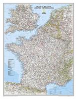
Wandkaart 22074 Frankrijk, België en Nederland, 60 x 77 cm | National Geographic
>Our classic wall map of France, Belgium, and the Netherlands shows political boundaries, major highways and roads, cities and towns, and a wealth of other incredibly accurate geographic detail.    France the map shows the division of the country into regions, with a list of their names and regional capitals (curiously, Corsica is not included on the map – what would Napoleon think of that?). The map also provides plenty of names of both geographical features (Pyrenees, Cevennes, etc) and the country’s traditional historical regions (Gascony, Maine, Bourbonais, etc). National parks are highlighted. Within Belgium the map indicates the division into Flanders, Wallonia and the Brussels Region and in the Netherlands boundaries of the country’s administrative provinces are marked. Topography is shown by relief shading and within the Netherlands the areas below the sea level are also indicated. The map shows the network of main road and rail connections, local airports, as well as ferry …
25,95

Klanten-reviews van Stadsplattegrond Darwin en omgeving | Hema Maps

Er zijn nog geen beoordelingen voor dit productBen jij de eerste die een review plaatst?

Meer over Stadsplattegrond Darwin en omgeving | Hema Maps

Productomschrijving

Stadsplattegrond van Darwin en de directe omgeving. Inclusief index.

Offering maps of the region, suburbs and Darwin’s CBD. Containing the entire city with primary, secondary and tertiary road patterns, city centre distance markers on major roads and postcode and road numbering, these maps are easy and helpful to use, making them appropriate for a wide range of users.

  • Easy to use
  • CBD map
  • Suburban map
  • Regional map
  • Postcodes
  • Points of interest
  • Fully indexed

Productinformatie

    Verken gerelateerde categorieën

    Webshop.nl maakt gebruik van cookies. Ga je verder op onze website, ga dan akkoord met het plaatsen van cookies en de verwerking van deze data door ons en vermelde partners.